Haycock, Alaska

Last updated

Haycock, Alaska
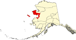
USA Alaska location map.svg
Red pog.svg
Haycock, Alaska
Coordinates: 65°12′35″N161°09′56″W / 65.20972°N 161.16556°W / 65.20972; -161.16556
Country United States
State Alaska
Census area Nome
Elevation
184 ft (56 m)
Time zone UTC-9 (Alaska (AKST))
  Summer (DST) UTC-8 (AKDT)
Area code 907
GNIS feature ID1403253 [1]

Haycock is an unincorporated community and mining camp in the Nome Census Area, Alaska, United States.

Contents

History

The community was founded in 1914 as a mining camp; it had a post office from 1916 until 1957. [1]

Demographics

Historical population
CensusPop.Note
1920 114
1930 71−37.7%
1940 8114.1%
U.S. Decennial Census [2]

Haycock first appeared on the 1920 U.S. Census as an unincorporated village. It appeared again in 1930 and 1940. It has not returned since.

Notable person

Notes

  1. 1 2 "Haycock, Alaska". Geographic Names Information System . United States Geological Survey, United States Department of the Interior.
  2. "U.S. Decennial Census". Census.gov. Retrieved June 6, 2013.
  3. 'Last Rites For Beltz Held Today,' Faorbanks Daily News Miner, November 23, 1960, pg. 1