Heidenrod

Last updated
Heidenrod
Wappen Heidenrod.png
Location of Heidenrod within Rheingau-Taunus-Kreis district
Heidenrod in RUD.svgHohenstein
Germany adm location map.svg
Red pog.svg
Heidenrod
Hesse location map.svg
Red pog.svg
Heidenrod
Coordinates: 50°12′36″N07°59′24″E / 50.21000°N 7.99000°E / 50.21000; 7.99000
Country Germany
State Hesse
Admin. region Darmstadt
District Rheingau-Taunus-Kreis
Government
   Mayor (201925) Volker Diefenbach [1] (SPD)
Area
  Total95.94 km2 (37.04 sq mi)
Elevation
361 m (1,184 ft)
Population
 (2022-12-31) [2]
  Total7,927
  Density83/km2 (210/sq mi)
Time zone UTC+01:00 (CET)
  Summer (DST) UTC+02:00 (CEST)
Postal codes
65321
Dialling codes 06120, 06124, 06772, 06775
Vehicle registration RÜD
Website www.heidenrod.de

Heidenrod is a municipality in the Rheingau-Taunus-Kreis in the Regierungsbezirk of Darmstadt in Hesse, Germany. Seat of municipal administration is to be found in the most populated municipal district, in Laufenselden.

Contents

Geography

Location

Heidenrod lies in the western Taunus north of the main ridge and west of the Aar, between Koblenz and Wiesbaden, roughly halfway between the Rhine and the Lahn. The municipal area stretches east and west of the high ridge along which runs Bundesstraße 260, also known as the Bäderstraße (“Bath Road”). The two highest settlements in the western Taunus, Kemel (village centre, 510 m above sea level) and Mappershain (village centre, 500 m above sea level) are Heidenrod municipal districts. The Mappershainer Kopf, some 500 m northwest of its namesake place, is at 548 m above sea level the highest mountain in the Western Hintertaunus ("Farther Taunus"). [3] [ circular reference ]

Within municipal limits, west of the municipal district of Kemel, rise the headwaters of the Wisper, which run together between the constituent communities of Wisper and Geroldstein. In the constituent community of Mappershain rises the Dörsbach. Some 60% of the municipal area is wooded.

Neighbouring communities

Heidenrod borders in the north on the municipalities of Holzhausen an der Haide, Rettert, Berndroth, Dörsdorf, Eisighofen and Reckenroth (all in the Rhein-Lahn-Kreis in Rhineland-Palatinate), in the northeast on the municipality of Aarbergen, in the east on the municipality of Hohenstein, in the southeast on the town of Bad Schwalbach, in the southwest on the town of Oestrich-Winkel, and in the west on the town of Lorch and the municipalities of Welterod, Strüth, Weidenbach, Diethardt and Nastätten (all in the Rhein-Lahn-Kreis).

Constituent communities

Heidenrod's 19 Ortsteile , with population figures as of Nov 2012, [4] are Algenroth (77), Dickschied (473), Egenroth (172), Geroldstein (91), Grebenroth (346), Hilgenroth (103), Huppert (525), Kemel (1219), Langschied (238), Laufenselden (1894), Mappershain (246), Martenroth (67), Nauroth (582), Niedermeilingen (328), Obermeilingen (93), Springen (406), Watzelhain (362), Wisper (94) and Zorn (447).

History

In 1972, the first merger took place when 17 self-governing municipalities amalgamated. Last but not least in 1977 Hilgenroth became part of Heidenrod by law.

Politics

Municipal council

The municipal election held on 6 March 2016 [5] [ circular reference ] yielded the following results:

Parties and voter communities%
2016
Seats
2016
%
2006
Seats
2006
%
2001
Seats
2001
CDU Christian Democratic Union of Germany 28.4938.51241.213
SPD Social Democratic Party of Germany 38.51235.61141.213
GREENS Bündnis 90/Die Grünen 9.937.328.42
FDP Free Democratic Party 4.714.625.52
BIHBürgerinitiative Heidenrod18.5614.04
DHPDeutsche Heimat Partei ... Die National-Liberalen3.81
Total100.031100.031100.031
Voter turnout in %59.254.761.0

Municipal partnerships

Heidenrod maintains partnerships with the following places:

Education

Famous people

Related Research Articles

Rheingau-Taunus is a Kreis (district) in the west of Hesse, Germany. Rheingau-Taunus-Kreis is part of the Darmstadt region; its main administrative seat is Bad Schwalbach. Outposted sections of the local administration are located in Idstein and Rüdesheim am Rhein.

Limburg-Weilburg is a Kreis (district) in the west of Hesse, Germany. Neighboring districts are Lahn-Dill, Hochtaunuskreis, Rheingau-Taunus, Rhein-Lahn, Westerwaldkreis.

<span class="mw-page-title-main">Schmitten im Taunus</span> Municipality in Hesse, Germany

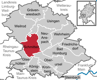
Schmitten im Taunus is a municipality in the Hochtaunuskreis in Hessen, Germany.

<span class="mw-page-title-main">Leun</span> Town in Hesse, Germany

Leun is a small town in the Lahn-Dill-Kreis in Hesse, Germany.

<span class="mw-page-title-main">Schlangenbad</span> Municipality in Hesse, Germany

Schlangenbad is a municipality in the Rheingau-Taunus-Kreis in the Regierungsbezirk of Darmstadt in Hesse, Germany.

<span class="mw-page-title-main">Bad Schwalbach</span> Town in Hesse, Germany

Bad Schwalbach is the district seat of Rheingau-Taunus-Kreis, in Hesse, Germany.

<span class="mw-page-title-main">Grävenwiesbach</span> Municipality in Hesse, Germany

Grävenwiesbach is a municipality in the Hochtaunuskreis in Hesse, Germany.

<span class="mw-page-title-main">Solms</span> Town in Hesse, Germany

Solms is a town west of Wetzlar in the Lahn-Dill-Kreis, Hessen, Germany with around 13,500 inhabitants. In the constituent community of Burgsolms once stood the ancestral castle of the Counts and Princes of Solms.

<span class="mw-page-title-main">Raunheim</span> Town in Hesse, Germany

Raunheim is a town in Groß-Gerau district in Hesse, Germany and a part of the Frankfurt Urban Region as well as the Frankfurt Rhein-Main Region.

<span class="mw-page-title-main">Oestrich-Winkel</span> Town in Hesse, Germany

Oestrich-Winkel is a town with roughly 12,000 inhabitants in the Rheingau-Taunus-Kreis in the Regierungsbezirk of Darmstadt in Hesse, Germany.

<span class="mw-page-title-main">Breitscheid, Hesse</span> Municipality in Hesse, Germany

Breitscheid is a municipality in the Lahn-Dill-Kreis in Hesse, Germany.

<span class="mw-page-title-main">Hünfelden</span> Municipality in Hesse, Germany

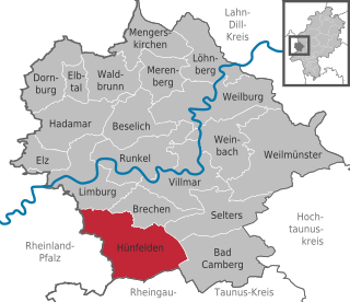
Hünfelden is a municipality in Limburg-Weilburg district in Hesse, Germany. Hünfelden lies on the Hühnerstraße, an historic part of Bundesstraße 417.

<span class="mw-page-title-main">Hohenahr</span> Municipality in Hesse, Germany

Hohenahr is a municipality in the Lahn-Dill-Kreis in Hesse, Germany.

<span class="mw-page-title-main">Sinn, Hesse</span> Municipality in Hesse, Germany

Sinn is a municipality in Middle Hesse, Germany, in the Lahn-Dill-Kreis.

<span class="mw-page-title-main">Waldsolms</span> Municipality in Hesse, Germany

Waldsolms is a municipality located in the Lahn-Dill-Kreis in Hesse, Germany.

<span class="mw-page-title-main">Weilrod</span> Municipality in Hesse, Germany

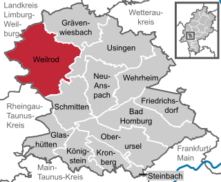
Weilrod is a municipality made up of several villages in the northwest Hochtaunuskreis lying in the Weil Valley in Hesse, Germany.

<span class="mw-page-title-main">Löhnberg</span> Municipality in Hesse, Germany

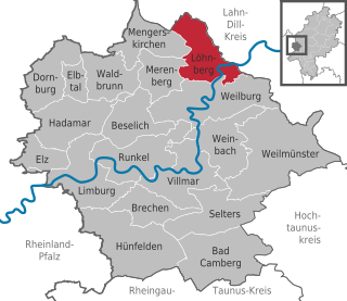
Löhnberg is a municipality north of Weilburg in Limburg-Weilburg district in Hesse, Germany.

<span class="mw-page-title-main">Aarbergen</span> Municipality in Hesse, Germany

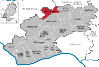
Aarbergen is a municipality in the Rheingau-Taunus-Kreis in the Regierungsbezirk of Darmstadt in Hesse, Germany.

<span class="mw-page-title-main">Hohenstein, Hesse</span> Municipality in Hesse, Germany

Hohenstein is a municipality in the Rheingau-Taunus-Kreis in the Regierungsbezirk of Darmstadt in Hesse, Germany.

<span class="mw-page-title-main">Waldems</span> Municipality in Hesse, Germany

Waldems is a municipality in the Rheingau-Taunus-Kreis in the Regierungsbezirk of Darmstadt in Hesse, Germany. The municipality's administrative seat is Waldems-Esch.

References

  1. "Ergebnisse der letzten Direktwahl aller hessischen Landkreise und Gemeinden" (XLS) (in German). Hessisches Statistisches Landesamt. 5 September 2022.
  2. "Bevölkerung in Hessen am 31.12.2022 nach Gemeinden" (XLS) (in German). Hessisches Statistisches Landesamt. June 2023.
  3. Taunus
  4. "Heidenrod".
  5. de:Heidenrod