Hempens Himpens | |
|---|---|
Village | |
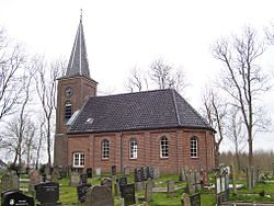 St Martin's Church | |
 Flag  Coat of arms | |
 Hempens Location in the Netherlands  Hempens Hempens (Netherlands) | |
| Coordinates: 53°11′N5°50′E / 53.183°N 5.833°E | |
| Country | |
| Province | |
| Municipality | |
| Area | |
• Total | 0.93 km2 (0.36 sq mi) |
| Elevation | 0 m (0 ft) |
| Population (2021) [1] | |
• Total | 285 |
| • Density | 310/km2 (790/sq mi) |
| Postal code | 9086 [1] |
| Dialing code | 058 |
Hempens (West Frisian : Himpens) is a village in Leeuwarden municipality in the province of Friesland, the Netherlands.
It was first mentioned in 1463 as Hempens, and means "settlement of the people of Hempe (person)". [3]
Hempens was an agricultural community. In 1840, it was home to 89 people. The church burnt down in 1945, and was rebuilt in 1948. [4]


