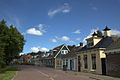
History
The village was first mentioned in 1366 as Goeltum, and means "settlement of Golde (person)". It was sometimes referred to as Dola-Goutum (Goutum on the border) to distinguish between Scharnegoutum. [4] Goutum developed on several terps (artificial living mounds) in the Middle Ages. [5]
The stins Wiarda State was located near Goutum, and was first mentioned in the 14th century. It was owned by the son of Sjoerd Wiarda, the potestaat (comparable to governor) of Friesland. In 1481, the Wiardas and the villagers of Goutum participated in an attack on the city of Leeuwarden, and were defeated. In 1482, Wiarda State was demolished by Leeuwarden. [6]
The Protestant church of Goutum dates from the 15th century and is located on top of a terp. The church has 11th and 12th century elements. [5]
In 1840, Goutum was home to 252 people. For most of its history, Goutum was a small village to the south of the provincial capital Leeuwarden. In 1944, it became part of the municipality of Leeuwarden. In 1948, Goutum was physically cut off from Leeuwarden by the construction of the van Harinxmakanaal. [7]
In the 1980s, the city planned to build thousands of houses near Goutum, however the village fought the city up to the Council of State and won. In 1990, new neighbourhoods started to appear near Goutum, but at a distance. As of 2021, it can be considered an enclave, however it still has its own statistical area, postal code, village house and village identity. [7]
This page is based on this
Wikipedia article Text is available under the
CC BY-SA 4.0 license; additional terms may apply.
Images, videos and audio are available under their respective licenses.