Heerhugowaard is a city in the Netherlands, in the province of North Holland and the region of West Friesland.

Hoorn is a city and municipality in the northwest of the Netherlands, in the province of North Holland. It is the largest town and the traditional capital of the region of West Friesland. Hoorn is located on the Markermeer, 20 kilometers (12 mi) east of Alkmaar and 35 kilometers (22 mi) north of Amsterdam. The municipality has just over 73,000 inhabitants and a land area of 20.38 km2 (7.87 sq mi), making it the third most densely populated municipality in North Holland after Haarlem and Amsterdam. Apart from the city of Hoorn, the municipality includes the villages of Blokker and Zwaag, as well as parts of the hamlets De Bangert, De Hulk and Munnickaij.
Wieringen is in the province of North Holland in the Netherlands. Now a part of the municipality of Hollands Kroon, before 2012 it was a separate municipality, its name appearing in 8th and 9th century records. By 1200 it was an island, also named Wieringen, separated from the mainland during one of the severe storm floods in the late Middle Ages that changed the coastline. By draining, dikes and landfill from 1924 to 1932, the island was rejoined to the mainland.
Wognum is a former municipality and a town in the Netherlands, in the province of North Holland. Wognum received city rights in 1392 but lost them in 1426. In 2007 it merged with the municipalities of Medemblik and Noorder-Koggenland into an enlarged municipality of Medemblik.

Koggenland is a municipality in North Holland province and the region of West-Frisia of the Netherlands. It came into existence on 1 January 2007 upon the merger of the two former municipalities of Obdam and Wester-Koggenland.

Eastermar is a village in Tytsjerksteradiel municipality in the province Friesland of the Netherlands. It had around 1,575 citizens in January 2017.
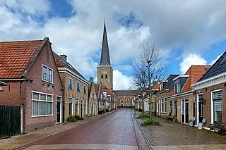
Tzum is a village in Waadhoeke municipality in the province of Friesland, the Netherlands. It had a population of around 1,110 in 2023. Tzum is known for its 72 metre tall church tower.

Sibrandahûs is a small village in the Dantumadiel municipality of Friesland, the Netherlands. It had a population of around 40 in 2017. It is located just west of Dokkum.

De Falom is a village in the Dantumadiel municipality of Friesland, the Netherlands. It had a population of 235 in 2017.

Readtsjerk is a village in the Dantumadiel municipality of Friesland, the Netherlands. It had a population of around 185 in 2017.

Rinsumageast is a village in the Dantumadiel municipality of Friesland, the Netherlands. It had a population of around 965 in 2017.

Broeksterwâld is a village in the Dantumadiel municipality of Friesland, in the Netherlands. In 2017, it had a population of around 1,100.

Feanwâlden is a village in the Dantumadiel municipality of Friesland, the Netherlands. It had a population of around 3,430 in 2014.

De Westereen is a village in the Dantumadiel municipality of Friesland, the Netherlands. It had a population of around 5,000 in 2017.
Driezum is a village in the Dantumadiel municipality of Friesland, the Netherlands. It had a population of around 850 in 2017.

Feanwâldsterwâl is a village in the Dantumadiel and Tytsjerksteradiel municipality's of Friesland, the Netherlands. it had a population of around 420 in 2021, however Feanwâldsterwâl is not a statistical entity, and the population count is only an estimation.

Laaxum is a hamlet in the municipality of Súdwest-Fryslân in the province of Friesland, the Netherlands.
Eastwâld is a hamlet in the municipality of Dantumadiel in the province of Friesland, the Netherlands.
De Puollen is a hamlet in the Dutch municipality of Waadhoeke in the province of Friesland. It is located to the south of Deinum and on the east side of Dronryp, of which it is a part administratively. The Puolfeart flows through the hamlet and its surrounding polder. This canal forms the heart of the hamlet, which consists of scattered residences on the Puoldyk.

Dyksterhuzen is a hamlet in the Dutch municipality of Waadhoeke in the province of Friesland. It is located northwest of Ingelum and east of Bitgummole, of which it is a part administratively. The settlement of the hamlet is located on the eponymous road, Dyksterhuzen. The residences are both houses and farms. The N398, a trunk road, forms the division between the hamlet and the village of Bitgummole.