Lekkum

Last updated
Lekkum
Village
20200922 Zicht1 op Lekkum.jpg
Map NL Ljouwert Lekkum.png
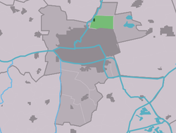
Location in Leeuwarden municipality
2010-NL-P02-Fryslan-positiekaart-gemnamen.jpg
Red pog.svg
Lekkum
Location in the Netherlands
Netherlands location map.svg
Red pog.svg
Lekkum
Lekkum (Netherlands)
Coordinates: 53°14′N5°49′E / 53.233°N 5.817°E / 53.233; 5.817
Country Flag of the Netherlands.svg Netherlands
Province Frisian flag.svg Friesland
Municipality Leeuwarden vlag 2014.svg Leeuwarden
Area
[1]
  Total
5.32 km2 (2.05 sq mi)
Elevation
[2]
0.6 m (2.0 ft)
Population
 (2021) [1]
  Total
435
  Density82/km2 (210/sq mi)
Postal code
9081 & 9082 [1]
Dialing code 058

Lekkum is a village in Leeuwarden municipality in the Friesland province of the Netherlands. It had a population of around 405 in January 2017. [3]

Contents

De Bullemolen in Lekkum marks the finishing point of the Elfstedentocht . [4]

History

The village was first mentioned in the 13th century as Lackum. The etymology is unclear. [5] The Dutch Reformed church was built in 1778 as a replacement of a medieval church. The tower was rebuilt in 1896. [6] The polder mill De Bullemolen was built in 1825. Since 2006, it serves as a backup from the pumping station. [7] In 1840, Lekkum was home to 127 people. [6]

Before 1944, Lekkum was part of Leeuwarderadeel municipality. [6]

References

  1. 1 2 3 "Kerncijfers wijken en buurten 2021". Central Bureau of Statistics. Retrieved 31 March 2022. two entries. overlap with Miedum
  2. "Postcodetool for 9081AD". Actueel Hoogtebestand Nederland (in Dutch). Het Waterschapshuis. Archived from the original on 21 September 2013. Retrieved 31 March 2022.
  3. Kerncijfers wijken en buurten 2017 - CBS Statline
  4. "Lekkum, Fryslân" (in Dutch). Molendatabase. Retrieved 1 May 2010.
  5. "Lekkum - (geografische naam)". Etymologiebank (in Dutch). Retrieved 31 March 2022.
  6. 1 2 3 "Lekkum". Plaatsengids (in Dutch). Retrieved 31 March 2022.
  7. "Bullemûne / De Bullemolen". Molendatabase (in Dutch). Retrieved 31 March 2022.