Warstiens | |
|---|---|
Village | |
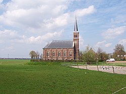 Warstiens church | |
 Flag  Coat of arms | |
 Location in the former Boarnsterhim municipality | |
 Warstiens Location in the Netherlands  Warstiens Warstiens (Netherlands) | |
| Coordinates: 53°10′N5°52′E / 53.167°N 5.867°E | |
| Country | |
| Province | |
| Municipality | |
| Area | |
• Total | 2.71 km2 (1.05 sq mi) |
| Elevation | 0.1 m (0.3 ft) |
| Population (2021) [1] | |
• Total | 30 |
| • Density | 11/km2 (29/sq mi) |
| Postal code | 9004 [1] |
| Dialing code | 058 |
Warstiens is a small village in Leeuwarden municipality in the province of Friesland, the Netherlands. It had a population of around 35 in January 2017. [3]


