Jellum

Last updated
Jellum
Village
Jellum.jpg
Jellum vlag.svg
Jellum wapen.svg
Map NL Littenseradiel Jellum.png
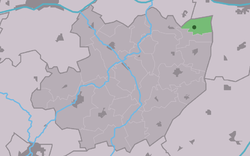
Location in the former Littenseradiel municipality
2010-NL-P02-Fryslan-positiekaart-gemnamen.jpg
Red pog.svg
Jellum
Location in the Netherlands
Netherlands location map.svg
Red pog.svg
Jellum
Jellum (Netherlands)
Country Flag of the Netherlands.svg Netherlands
Province Frisian flag.svg Friesland
Municipality Leeuwarden vlag 2014.svg Leeuwarden
Area
[1]
  Total
3.25 km2 (1.25 sq mi)
Elevation
[2]
0.9 m (3.0 ft)
Population
 (2021) [1]
  Total
150
  Density46/km2 (120/sq mi)
Time zone UTC+1 (CET)
  Summer (DST) UTC+2 (CEST)
Postal code
9026 [1]
Dialing code 058

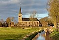
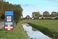
Jellum is a village in Leeuwarden in the province of Friesland, the Netherlands. It had a population of around 142 in January 2017. [3]

Contents

History

The village was first mentioned in the 13th century as Helmum, and means "settlement of the people of Helm (person)". [4] The Dutch Reformed church dated from around 1700. In 1893, it was struck by lightning and both the church and tower burnt down. In 1895, it was rebuilt with a 21 metres (69 ft) tall tower. In 1840, Jellum was home to 96 people. [5]

Before 2018, the village was part of the Littenseradiel municipality and before 1984 it belonged to Baarderadeel municipality. [5]

References

  1. 1 2 3 "Kerncijfers wijken en buurten 2021". Central Bureau of Statistics. Retrieved 30 March 2022.
  2. "Postcodetool for 9026BA". Actueel Hoogtebestand Nederland (in Dutch). Het Waterschapshuis. Archived from the original on 21 September 2013. Retrieved 30 March 2022.
  3. Aantal inwoners per dorp Archived 2017-04-21 at the Wayback Machine - Littenseradiel
  4. "Jellum - (geografische naam)". Etymologiebank (in Dutch). Retrieved 30 March 2022.
  5. 1 2 "Jellum". Plaatsengids (in Dutch). Archived from the original on 31 March 2022. Retrieved 30 March 2022.