
St Albans is a cathedral city in Hertfordshire, England, east of Hemel Hempstead and west of Hatfield, 20 miles (32 km) north-west of London, 8 miles (13 km) south-west of Welwyn Garden City and 11 miles (18 km) south-east of Luton. St Albans was the first major town on the old Roman road of Watling Street for travellers heading north and became the city of Verulamium. It is within the London commuter belt and the Greater London Built-up Area.

Worcestershire is a ceremonial county in the West Midlands of England. It is bordered by Shropshire, Staffordshire, and the West Midlands county to the north, Warwickshire to the east, Gloucestershire to the south, and Herefordshire to the west. The city of Worcester is the largest settlement and the county town.

Winchester is a cathedral city in Hampshire, England. The city lies at the heart of the wider City of Winchester, a local government district, at the western end of the South Downs National Park, on the River Itchen. It is 60 miles (97 km) south-west of London and 14 miles (23 km) from Southampton, its nearest city. At the 2021 census, the built-up area of Winchester had a population of 48,478. The wider City of Winchester district includes towns such as Alresford and Bishop's Waltham and had a population of 127,439 in 2021. Winchester is the county town of Hampshire and contains the head offices of Hampshire County Council.

Worcester is a cathedral city in Worcestershire, England, of which it is the county town. It is 30 mi (48 km) south-west of Birmingham, 27 mi (43 km) north of Gloucester and 23 mi (37 km) north-east of Hereford. The population was 103,872 in the 2021 census.
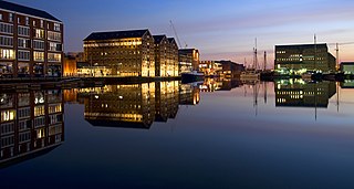
Gloucester is a cathedral city and the county town of Gloucestershire in the South West of England. Gloucester lies on the River Severn, between the Cotswolds to the east and the Forest of Dean to the west; it is sited 19 miles (31 km) east of Monmouth and 17 miles (27 km) east of the border with Wales. Gloucester has a population of around 132,000, including suburban areas. It is a port, linked via the Gloucester and Sharpness Canal to the Severn Estuary.

Worcester Cathedral, formally the Cathedral Church of Christ and Blessed Mary the Virgin, is a Church of England cathedral in Worcester, England. The cathedral is the seat of the bishop of Worcester and is the mother church of the diocese of Worcester; it is administered by its dean and chapter. The cathedral is a grade I listed building and part of a scheduled monument.

Sherborne Abbey, otherwise the Abbey Church of St. Mary the Virgin, is a Church of England church in Sherborne in the English county of Dorset. It has been a Saxon cathedral (705–1075), a Benedictine abbey church (998–1539), and since 1539, a parish church.

Tidworth is a garrison town and civil parish in south-east Wiltshire, England, on the eastern edge of Salisbury Plain. Lying on both sides of the A338 about 3+1⁄2 miles (5.6 km) north of the A303 primary route, the town is approximately 8 miles (13 km) west of Andover, 12 miles (19 km) south of Marlborough, and 13 miles (21 km) north by north-east of Salisbury. The population of the parish at the 2011 census was approximately 10,600.

Nunhead is a suburb in the London Borough of Southwark, England. It is an inner-city suburb located 4 miles (6.4 km) southeast of Charing Cross. It is the location of the 52-acre (0.21 km2) Nunhead Cemetery. Nunhead has traditionally been a working-class area and, with the adjacent neighbourhoods, is currently going through a lengthy process of gentrification. Nunhead is the location of several underground reservoirs, built by the Southwark and Vauxhall Waterworks Company.
Warndon is a northeastern suburb of Worcester in Worcestershire, England. It is also a civil parish which is named after the suburb.

St Peter the Great County, also known as St Peter the Great or St Peter is a southern suburb of Worcester in Worcestershire, England. It is also a civil parish and is known as St. Peters. It lies on the east side of the River Severn and near Junction 7 of the M5 motorway. In the 2011 census, the parish population was recorded as 5,851.
Harnham is a suburb of the city of Salisbury in Wiltshire, England, centred about 0.6 miles (1 km) south of Salisbury Cathedral and across the River Avon. Harnham is split into the areas of West Harnham and East Harnham.

All Hallows Lombard Street, also seen with the descriptor Gracechurch Street, was a parish church in the City of London. It stood behind thin buildings fronting both streets in Langbourn Ward, The west and south sides faced into Ball Alley. Of medieval origin, it was rebuilt after the Great Fire of London. It was demolished in 1937; its tower was reconstructed at Twickenham as part of the new church of All Hallows, which also received its bells and complete interior fittings.

All Hallows, Honey Lane was a parish church in the City of London, England. Of medieval origin, it was destroyed in the Great Fire of London in 1666 and not rebuilt; the site became part of Honey Lane Market, which was in turn partially cleared to make way for the City of London School in the 19th century. Much of the area was destroyed during the bombing in World War II and has been redeveloped. The name Honey Lane is retained in a nearby walkway.

St John the Evangelist's Church is in Weston, once a separate village and now part of the town of Runcorn, Cheshire, England. The church is recorded in the National Heritage List for England as a designated Grade II* listed building. It is an active Anglican parish church in the diocese of Chester, the archdeaconry of Chester and the deanery of Frodsham. Its design has been described as "bold and original".

St John's is a western suburb of Worcester in Worcestershire, England, lying west of the city centre and the River Severn. St. John's is referred to locally as the "Village in the City", which is partly due to being an independent township, before joining the city in 1837. There is still a sense of identity within the community.

Bengeworth is a locality in the civil parish of Evesham, in the Wychavon district, in the county of Worcestershire, England. In 1887 it had a population of 1,311. Today it has a school and an Anglican church.

Hallow is a village and civil parish beside the River Severn, about 2 miles (3.2 km) north-west of Worcester in Worcestershire. The village is on the A443 road that links Worcester with Holt Heath.

Worcester's early importance is partly due to its position on trade routes, but also because it was a centre of Church learning and wealth, due to the very large possessions of the See and Priory accumulated in the Anglo-Saxon period. After the reformation, Worcester continued as a centre of learning, with two early grammar schools with strong links to Oxford University.


