Heretaunga | |
---|---|
Coordinates: 41°08′35″S175°01′12″E / 41.143°S 175.020°E | |
Country | New Zealand |
Region | Wellington Region |
Territorial authority | Upper Hutt |
Electorates | |
Government | |
• Territorial Authority | Upper Hutt City Council |
• Regional council | Greater Wellington Regional Council |
• Mayor of Upper Hutt | Wayne Guppy |
• Remutaka MP | Chris Hipkins |
• Ikaroa-Rāwhiti MP | Cushla Tangaere-Manuel |
Area | |
• Total | 3.26 km2 (1.26 sq mi) |
Population (June 2023) [2] | |
• Total | 2,530 |
• Density | 780/km2 (2,000/sq mi) |
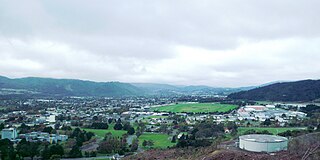
Heretaunga is a suburb of the city of Upper Hutt, located in the lower (southern) North Island of New Zealand. Heretaunga adjoins the suburb of Silverstream to its southwest and the two are commonly thought of associated with each other. To the northeast lies Trentham. The Heretaunga Railway Station on the Hutt Valley Line serves the suburb.
Heretaunga takes its name from one of the Māori names for the nearby Hutt River, originating from a Hawke's Bay district. [3] [4] Heretaunga as a Māori name combines here, meaning "to tie up", and Tauranga, literally meaning "to be at home" - the name originated with a mooring place for canoes. [3]
The settlement, one of the older suburbs in the Hutt Valley, dates from the 1840s when European settlers sought country sections. [5] [ need quotation to verify ] A prime example of a "leafy" suburb, Heretaunga includes quiet tree-lined streets. It is characterised by large houses, often Edwardian or from the mid-20th century.
The suburb has numerous green spaces, most evident around the site of the Royal Wellington Wellington Golf Club and Trentham Memorial Park. The Royal Wellington Golf Club has been based in Heretaunga since 20 November 1906 after acquiring 48.5 hectares of land from the Barton family (descendants of Richard Barton). [6]
The Mawaihakona Stream begins at a spring in Trentham Memorial Park and drains the western side of the Hutt Valley from Trentham to Heretaunga. The stream passes around Heretaunga Park and the perimeter of the playing fields of St Patrick's College, Silverstream. It flows into the Hutt River north of the Silverstream bridge. [7] [8]
Heretaunga's statistical area covers 3.26 km2 (1.26 sq mi). [1] It had an estimated population of 2,530 as of June 2023, with a population density of 776 people per km2.
Year | Pop. | ±% p.a. |
---|---|---|
2006 | 2,223 | — |
2013 | 2,199 | −0.15% |
2018 | 2,496 | +2.57% |
Source: [9] |
Heretaunga had a population of 2,496 at the 2018 New Zealand census, an increase of 297 people (13.5%) since the 2013 census, and an increase of 273 people (12.3%) since the 2006 census. There were 930 households, comprising 1,248 males and 1,248 females, giving a sex ratio of 1.0 males per female. The median age was 41.6 years (compared with 37.4 years nationally), with 474 people (19.0%) aged under 15 years, 426 (17.1%) aged 15 to 29, 1,062 (42.5%) aged 30 to 64, and 537 (21.5%) aged 65 or older.
Ethnicities were 81.1% European/Pākehā, 12.5% Māori, 5.9% Pasifika, 10.2% Asian, and 2.4% other ethnicities. People may identify with more than one ethnicity.
The percentage of people born overseas was 23.7, compared with 27.1% nationally.
Although some people chose not to answer the census's question about religious affiliation, 37.6% had no religion, 51.1% were Christian, 0.5% had Māori religious beliefs, 2.2% were Hindu, 0.5% were Muslim, 0.6% were Buddhist and 1.8% had other religions.
Of those at least 15 years old, 525 (26.0%) people had a bachelor's or higher degree, and 327 (16.2%) people had no formal qualifications. The median income was $34,200, compared with $31,800 nationally. 480 people (23.7%) earned over $70,000 compared to 17.2% nationally. The employment status of those at least 15 was that 966 (47.8%) people were employed full-time, 267 (13.2%) were part-time, and 75 (3.7%) were unemployed. [9]
St Brendan's School is a co-educational state-integrated Catholic primary school for Year 1 to 8 students, [10] [11] with a roll of 253 as of February 2024. [12]
Upper Hutt is a city in the Wellington Region of New Zealand and one of the four cities that constitute the Wellington metropolitan area.
The Hutt River flows through the southern North Island of New Zealand. It flows south-west from the southern Tararua Range for 56 kilometres (35 mi), forming a number of fertile floodplains, including Kaitoke, central Upper Hutt and Lower Hutt.
Trentham is the most populous suburb of Upper Hutt, a city in the Wellington region of New Zealand. The suburb is located in a widening of the Hutt Valley, five kilometres to the southwest of the Upper Hutt city centre.
Petone is a large suburb of Lower Hutt, Wellington. It stands at the southern end of the Hutt Valley, on the northern shore of Wellington Harbour.
Silverstream is a suburb of Upper Hutt in New Zealand, just under 7 km (4.3 mi) south-west of the Upper Hutt CBD. It is in the lower (southern) part of the North Island of New Zealand at the southern end of Upper Hutt, close to the Taitā Gorge, which separates Upper Hutt from Lower Hutt. The area is sited at the mouth of a small valley formed by the Wellington Region's tectonic activity and, in part, by Hull's Creek, which discharges into the Hutt River.
Te Mārua is the easternmost urban suburb of Upper Hutt. For reasons of location and distance from the city, the area is often classified as rural. In December 2019, the approved official geographic name of the locality was gazetted as "Te Mārua".
Alicetown is a central suburb of Lower Hutt located at the bottom of the North Island of New Zealand.
Tōtara Park is a suburb of Upper Hutt, New Zealand, located 2 km northeast of the city centre. It is accessed via the Tōtara Park Bridge which crosses the Hutt River, connecting it to State Highway 2 and the main Upper Hutt urban area. It was popular in the 1970s and 1980s for families moving into the Upper Hutt area.
Waterloo is an eastern suburb of Lower Hutt, Wellington. It is named after the Battle of Waterloo won by the Duke of Wellington in 1815.
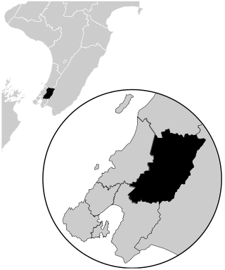
Remutaka is an electorate returning one member to the New Zealand House of Representatives. Since the 2008 general election, the seat has been represented by Chris Hipkins, who served as Prime Minister of New Zealand and is currently the Leader of the Opposition.
Wallaceville is a suburb of Upper Hutt. It is named after John Howard Wallace, an early New Zealand settler, council politician, businessman and author of one of the first published histories of New Zealand.
Maoribank is a suburb of Upper Hutt, located 2–3 km east-northeast of the city centre. It was predominantly developed between 1950-1970 and had a population of just less than 1000 at the 2013 Census.
Brown Owl is a suburb of Upper Hutt, located 3–4km from the city centre. It developed slowly from the 1960s
Lower Hutt is a city in the Wellington Region of New Zealand. Administered by the Hutt City Council, it is one of the four cities that constitute the Wellington metropolitan area.
Boulcott is a central suburb of Lower Hutt, in the Wellington Region of New Zealand. The suburb lies about a kilometre north-east of the Lower Hutt CBD.
Waiwhetū is an eastern suburb of Lower Hutt in the Wellington Region situated in the south of the North Island of New Zealand.
Maungaraki is a suburb of Lower Hutt. It is one of several Lower Hutt suburbs on the western hills of the Hutt Valley. It contains the largest suburban development on the Hutt Valley's western escarpment that runs along the Wellington Fault.
Korokoro, a suburb of Lower Hutt City, lies in the south of the North Island of New Zealand. The suburb occupies part of the western hills of the Hutt Valley; its eastern slopes overlook Petone and the Wellington harbour.
Trentham Memorial Park is a large park and a major sport and recreation ground in Trentham, a suburb of Upper Hutt, in the Wellington region of New Zealand.
The Mawaihakona Stream is a small watercourse in Upper Hutt, in the North Island of New Zealand. The stream begins at a spring in Trentham Memorial Park and drains the western side of the Hutt Valley from Trentham to Heretaunga. The stream passes around Heretaunga Park and the perimeter of the playing fields of St Patrick's College, Silverstream. It flows into the Hutt River north of the Silverstream bridge.
Early residents such as the Ngāi Tara people called the Hutt River Te Awakairangi, 'the watercourse of greatest value'. It was navigable by canoe far inland, giving access to plentiful food. Later tribes knew it as Te Wai o Orutu, 'the waters of Orutu', a Ngāti Māmoe ancestor. When European settlers arrived it was known as the Heretaunga River, after the district in Hawke's Bay.