Herschel | |
|---|---|
 Herschel  Herschel | |
| Coordinates: 30°36′54″S27°9′43″E / 30.61500°S 27.16194°E | |
| Country | South Africa |
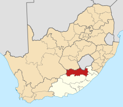
| Province | Eastern Cape |
| District | Joe Gqabi |
| Municipality | Senqu |
| Area | |
• Total | 4.48 km2 (1.73 sq mi) |
| Elevation | 1,830 m (6,000 ft) |
| Population (2011) [1] | |
• Total | 2,189 |
| • Density | 490/km2 (1,300/sq mi) |
| Racial makeup (2011) | |
| • Black African | 99.9% |
| • Coloured | 0.1% |
| First languages (2011) | |
| • Xhosa | 7.5% |
| • Sotho | 10.1% |
| • Hlubi | 80% |
| • Other | 2.3% |
| Time zone | UTC+2 (SAST) |
| Postal code (street) | 9756 |
| PO box | 9756 |
| Area code | 051-603 |
Herschel is a settlement in Joe Gqabi District Municipality in the Eastern Cape province of South Africa.
The village is situated 19 kilometres (12 mi) north of Lady Grey, due east of Aliwal North. Founded in 1879, it was named after the astronomer Sir John Herschel who worked in the Cape Colony from 1834 to 1838, making observations of Halley's Comet amongst his other astronomical work. [2]