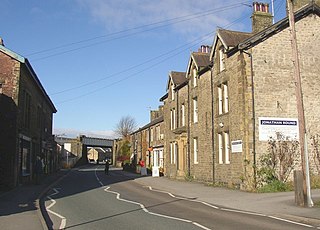
Hellifield is a village and civil parish in North Yorkshire, England. Historically part of the West Riding of Yorkshire, the village was once an important railway junction on the Settle-Carlisle Railway between the Midland Railway and the Lancashire and Yorkshire Railway, but Hellifield railway station is now a shadow of its former glory. It is situated on the A65, between Skipton and Settle. Hellifield had a population of 1,060 residents at the 2001 census, increasing to 1,426 at the 2011 census.
Beal is a village and civil parish in North Yorkshire, England. It is situated on the River Aire, 3.5 miles (6 km) north-east of Knottingley, 8 miles (13 km) south-west of Selby, and 21 miles (34 km) south of York. The parish includes the village of Kellingley, and borders the City of Wakefield in West Yorkshire. At the 2001 census it had a population of 720, increasing to 738 at the 2011 census.
Bordley is a village in the civil parish of Hetton-cum-Bordley, in North Yorkshire, England, within the Yorkshire Dales National Park and 12 miles (19 km) north of Skipton. According to the 2001 census the parish had a population of 23.

Burnsall is a village and civil parish in the Craven district of North Yorkshire, England. It is situated on the River Wharfe in Wharfedale, and is in the Yorkshire Dales National Park.

Conistone is a small village in the Craven district of North Yorkshire, England. It lies 3 miles (5 km) north of Grassington, 3 miles (5 km) south of Kettlewell and 12 miles (19 km) north of Skipton beside the River Wharfe, in Upper Wharfedale.
East Witton is a village and civil parish in Wensleydale in North Yorkshire, England. It lies south of Leyburn, in the Richmondshire district. Richard Whiteley is buried there; he and his partner, Kathryn Apanowicz, lived in the village.

Holme is a small village and civil parish in the Hambleton District of North Yorkshire, England. It is located near Pickhill, Sinderby and Ainderby Quernhow, on the west bank of the River Swale. The population of the civil parish was estimated at 60 in 2014.

Cracoe is a small village and civil parish in the Craven district of North Yorkshire, England. It is situated near to Rylstone and about 6 miles south-west of Grassington. Cracoe has an estimated population of 160 residents, measured at 178 in the 2011 census. Cracoe is a village which is also situated near Rylstone beneath Barden Fell and the twin skyline landmarks of Rylstone Cross and Cracoe Pinnacle in the Yorkshire Dales.

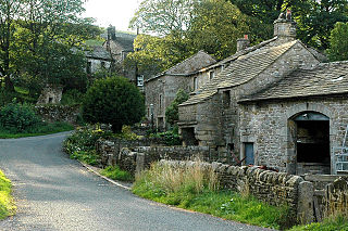
Hanlith is a small village and civil parish in the Craven district of North Yorkshire, England. It is situated near Kirkby Malham and the tourist attraction of Malham Cove. It is about 10 miles (16 km) north west of Skipton, and consists of only 13 houses. Its population was estimated at 40 in 2015.

Nappa is a hamlet in the civil parish of Hellifield, in North Yorkshire, England. It is on the A682 road and 6 miles (9.7 km) north-west of Barnoldswick and 10.5 miles (17 km) west of Skipton. The population was estimated at 10 in 2010.

Rylstone is a village and civil parish in the Craven district of North Yorkshire, England. It is situated very near to Cracoe and about 6 miles (9.7 km) south west of Grassington. The population of the civil parish as of the 2001 census was 122, and had risen to 160 by the time of the 2011 census. In 2015, the population was estimated to be 180.

Swinden is a village in the civil parish of Hellifield, in North Yorkshire, England. It is near Halton West and Nappa and about 7 miles north of Barnoldswick. The population was estimated at 20 in 2010.
Thorpe is a hamlet and civil parish in Wharfedale, North Yorkshire, England. It is 2 miles (3 km) south of Grassington and 6 miles (10 km) north of Skipton. At the 2011 census the population remained less than 100, so the details were included in the civil parish of Burnsall. However in 2015, North Yorkshire County Council estimated the population to be 50.
Hartlington is a small village and civil parish in the Craven district of North Yorkshire, England. At the 2011 Census, the population of the parish was around 50. Details are included in the civil parish of Hebden, North Yorkshire. It is under a mile east from the nearby village of Burnsall, which can be reached by going down Cross Hill. Hartlington is also just over a mile west of the village of Appletreewick. It is around 4 miles south-east of the small town of Grassington, and can be reached by going through the village of Hebden. Hartlington Raikes, one of the main roads in Hartlington, goes from Lower Hartlington to Upper Hartlington, to the B6265 approximately 1.5 miles away. The road then turns into Hartlington Moor Lane, which goes up to Grimwith Reservoir.

Checkley cum Wrinehill is a former civil parish, now in the parish of Doddington and District, in the unitary authority area of Cheshire East and the ceremonial county of Cheshire, England, which lies adjacent to the boundaries with Shropshire and Staffordshire. The hamlet of Checkley lies to the south east of Crewe and to the west of Newcastle-under-Lyme. The parish is largely rural but also includes the small settlements of Bunkers Hill and Randilow. Wrinehill was formerly included in the parish, becoming part of Staffordshire in 1965. Nearby villages include Blakenhall, Bridgemere, Madeley and Woore. In 2001 the parish had a population of 129.

Sutton is a small village in the civil parish of Byram cum Sutton, in North Yorkshire, England. It lies 1 mile north of Knottingley, across the River Aire in West Yorkshire.

Malham Moor is a civil parish in the Craven district of North Yorkshire, England. Its population was estimated at 70 in 2015.

Kirklington-cum-Upsland is a civil parish in the Hambleton district of North Yorkshire, England. The main settlement is Kirklington. Upsland is a single farm in the south-west of the parish.

Howgrave is a civil parish in the Hambleton District of North Yorkshire, England. It is a very small parish, with an area of only 323 acres (131 ha) and an estimated population in 2014 of only 10. There is no modern village in the parish. The site of the deserted medieval village of Howgrave lies in the west of the parish, 0.3 miles (0.5 km) west of the village of Sutton Howgrave.

Flasby is a hamlet in the Yorkshire Dales in North Yorkshire, England. It is one of the two settlements, with Winterburn, in the civil parish of Flasby with Winterburn, part of the Craven district. The population of the civil parish was estimated at 80 in 2012, measured at 207 in the 2011 Census.

