
The Saale, also known as the Saxon Saale and Thuringian Saale, is a river in Germany and a left-bank tributary of the Elbe. It is not to be confused with the smaller Franconian Saale, a right-bank tributary of the Main, or the Saale in Lower Saxony, a tributary of the Leine.

The Fichtel Mountains is a mountain range in Germany and the Czech Republic. They extend from the valley of the Red Main River in northeastern Bavaria to the Karlovy Vary Region in western Czech Republic. The Fichtel Mountains contain an important nature park, the Fichtel Mountain Nature Park. The Elster Mountains are a part of the Fichtel Mountains.

The Rhön Mountains are a group of low mountains in central Germany, located around the border area where the states of Hesse, Bavaria and Thuringia come together. These mountains, which are at the extreme southeast end of the East Hesse Highlands, are partly a result of ancient volcanic activity. They are separated from the Vogelsberg Mountains by the river Fulda and its valley. The highest mountain in the Rhön is the Wasserkuppe, which is in Hesse. The Rhön Mountains are a popular tourist destination and walking area.
Hohe Warte may refer to the following geographical locations:
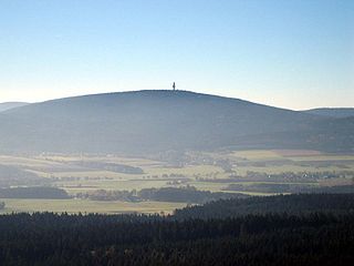
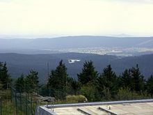
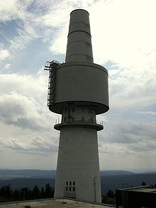
Schneeberg is the highest mountain in the Fichtel Mountains, a mountain range in Upper Franconia in northeast Bavaria, Germany. It can be readily identified from a distance by its squat tower - a relic of the Cold War. The summit comprises a jumble of granite rocks and a rock pillar (Felsburg) on which the Backöfele observation tower stands and is still dominated by the relics of military installations including its Cold War listening post.
The Thuringian-Franconian Highlands are a natural region of Germany which is designated as D48 or 39 by the BfN. It consists mainly of a ridge of mountains up to just under 1,000 m high between the Central Upland areas of the Thuringian Forest, Thuringian Slate Mountains, Franconian Forest and Fichtel Mountains, and which runs from west and south Thuringia through Upper Franconia and southeast to just before the Czech border and the so-called Bohemian Massif.
The Saxon Highlands and Uplands refer to a natural region mainly in the south of Saxony with small elements also in southeast Thuringia and northeast Bavaria. It comprises, from (south)west to (north)east, of the Vogtland, the Ore Mountains, Saxon Switzerland, the Upper Lusatian Plateau and the Zittau Hills.

The Fichtel Mountain Nature Park lies in the tri-border area of Saxony, the Czech Republic and Bavaria and has an area of 1,020 km2 (390 sq mi). It is maintained by the Naturpark Fichtelgebirge e. V. in Wunsiedel.
At 946 metres (3,104 ft), the Platte is the highest mountain in the Steinwald, a forest in the Fichtel mountain range in central Germany.
The Platte is a summit, 885 metres (2,904 ft) high in the Fichtel Mountains in central Germany. It is located between two other elevations, the Seehügel and the Hohe Matze, halfway between the Ochsenkopf and Kösseine mountains, on the Rhine-Elbe watershed.

The Fichtelgebirge Club is a large walking club and local heritage society in Bavaria and recognised conservation group with 20,000 members in 55 local groups. As the name says, its main sphere of activity is in the Fichtel Mountains in north Bavaria. Its emblem is the Arctic starflower.
The Nußhardt is the third highest mountain in the Fichtel Mountains in the south German state of Bavaria at 972 m above sea level (NN). It lies in the far northeast of the state and has a rocky summit characteristic of the Fichtel Mountains. The summit area with its felsenmeer and tor is a nature reserve with an area of 5.5 hectares. In addition the Nußhardt is incorporated into the geotope register of the Bavarian State Geological Department under No. 472R013.

The Steinwald is a mountain range up to 946 m above sea level (NN) in southern Germany and, at the same time, a nature park founded in 1970 with an area of 246 square kilometres (95 sq mi) in the province of Upper Palatinate, in North Bavaria.
The Großer Waldstein is part of the Waldstein range in the Fichtel Mountains of Germany. It is known primarily for its rock formations caused by spheroidal weathering, its ruined castles and the only remaining bear trap (Bärenfang) in the region.

The Waldstein is a mountain range in the northern part of the Fichtel Mountains in Upper Franconia, Bavaria, in southern Germany.
The Königsheide is a high, forested ridge, made of gneiss-phyllite rock in the Fichtel Mountains in Bavaria, Germany. It is located to the southwest of the Ochsenkopf mountain. It is bordered to the east and south by the river of the Warme Steinach, and to the west by the Franconian Line. The villages of Warmensteinach and Weidenberg and the town of Goldkronach lie on the Königsheide.

The Hoher Stein is a rock formation at the northeastern foot of the Bergkopf mountain, part of the Waldstein ridge in Germany's Fichtel Mountains.

The Bergkopf is an 857 metre high, thickly forested mountain in the Sparneck Forest in Germany's Fichtel Mountains.
The Upper Palatine-Upper Main Hills, also called the Upper Palatine-Upper Main Hills and Uplands form a landscape of low, rolling hills between the Franconian Jura in the southwest and the Franconian Forest, Fichtel Mountains and Upper Palatine Forest in the northeast.


