Hickory is a type of tree found in North America and East Asia.

Hickory County is a county located in the U.S. state of Missouri. As of the 2010 census, the population was 9,627. Its county seat is Hermitage. The county was organized February 14, 1845, and named after President Andrew Jackson, whose nickname was "Old Hickory." The Pomme de Terre Dam, a Corps of Engineers facility, is located three miles south of Hermitage and forms Lake Pomme de Terre by damming the Pomme de Terre River and Lindley Creek. The county is also home to Lucas Oil Speedway at Wheatland that includes a major circle dirt racing track, an off-road racing track as well as a large man-made water drag racing facility. Truman Reservoir, also a Corps of Engineers facility, floods the Pomme de Terre Reservoir from the northern border of the county southward to the city limits of Hermitage.
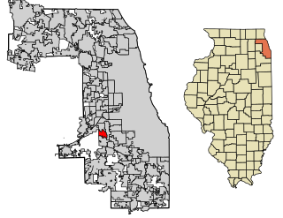
Hickory Hills is a city in Cook County, Illinois, United States. The population was 14,049 at the 2010 census.

Hickory Hill is a home rule-class city in Jefferson County, Kentucky, United States. The population was 114 at the 2010 census.
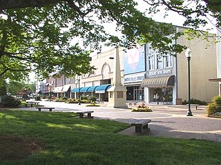
Hickory is a city in Catawba county in the U.S. state of North Carolina. The city's population at the 2010 census was 40,010, with an estimated population in 2015 of 40,374. Hickory is the principal city in the Hickory–Lenoir–Morganton MSA, in which the population at the 2010 census was 365,497 and is included as part of the Charlotte–Concord Combined Statistical Area.

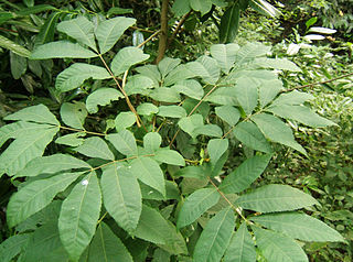
Hickory is a type of tree, comprising the genus Carya. The genus includes 17 to 19 species. Five or six species are native to China, Indochina, and India (Assam), as many as 12 are native to the United States, four are found in Mexico, and two to four are from Canada. A number of hickory species are used for products like edible nuts or wood.

The Cumberland Plateau is the southern part of the Appalachian Plateau in the Appalachian Mountains of the United States. It includes much of eastern Kentucky and Tennessee, and portions of northern Alabama and northwest Georgia. The terms "Allegheny Plateau" and the "Cumberland Plateau" both refer to the dissected plateau lands lying west of the main Appalachian Mountains. The terms stem from historical usage rather than geological difference, so there is no strict dividing line between the two. Two major rivers share the names of the plateaus, with the Allegheny River rising in the Allegheny Plateau and the Cumberland River rising in the Cumberland Plateau in Harlan County, Kentucky.

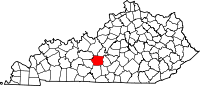
Hickory is a census-designated place in Graves County, Kentucky, United States., which is located north of Mayfield and 18 miles (29 km) south of Paducah in far western Kentucky.
Schnitzelburg is a neighborhood three miles southeast of downtown Louisville, Kentucky. Schnitzelburg's boundaries are Clarks Lane to the south, Shelby Street to the west, CSX railroad tracks to the north, and Goss Avenue to the east.
Castner Knott Company was a Nashville, Tennessee-based regional department store chain which operated stores in Kentucky and Alabama, along with Tennessee. The chain was in business for a century from 1898 to 1998, in its later years as a division of Mercantile Stores Company.
Carya cordiformis, the bitternut hickory, also called bitternut or swamp hickory, is a large pecan hickory with commercial stands located mostly north of the other pecan hickories. Bitternut hickory is cut and sold in mixture with the true hickories. It is the shortest-lived of the hickories, living to about 200 years.
Auburndale is a neighborhood on the south side of Louisville, Kentucky, United States. Its boundaries are Palatka Road to the north, and New Cut Road and Third Street to the east.

Hickory Hill is a middle-class, predominantly African-American community in the Southeast region of Memphis, Tennessee.

Hickory High School is a high school in Chesapeake, Virginia. There are approximately 2,100 students. The mascot is a hawk and the school colors are teal, grey, white, and black.

Pine Mountain is a ridge in the Appalachian Mountains running through Kentucky, Virginia and Tennessee. It extends about 125 miles from near Jellico, Tennessee, to a location near Elkhorn City, Kentucky. Birch Knob, the highest point, is 3,273 feet above sea level and is located on the Kentucky-Virginia border. It has been a barrier to transportation as the Cumberland River at Pineville, Kentucky is one of only two streams passing through the entire ridge. The other is Hickory Creek near Jellico, TN.
Creme Fraiche was an American Thoroughbred racehorse.

Hickory Heights is an unincorporated community of South Fayette Township, Allegheny County, Pennsylvania, United States.

Hickory Hollow Natural Area Preserve is a 254-acre (1.03 km2) Natural Area Preserve located in Lancaster County, Virginia. The preserve's mixed pine-hardwood forests, ravines, and swampland form a habitat for various songbirds, wild turkeys, and a rare species of plant. The swamp is an example of a globally rare natural community known as a "coastal plain basic seepage swamp", and supports a high level of biological diversity.
Boaz is an unincorporated community in Graves County, Kentucky, United States.