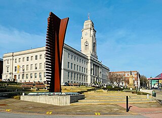
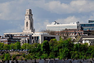
Barnsley is a market town in South Yorkshire, England. It is the main settlement of the Metropolitan Borough of Barnsley and the fourth largest settlement in South Yorkshire. The town's population was 96,888 in 2021, while the wider borough had a population of 244,600 in the 2021 census.
Darton is a large village in the Metropolitan Borough of Barnsley, on the border with West Yorkshire, England. At the time of the 2001 UK census, it had a population of 14,927, increasing to 21,345 for both Darton Wards at the 2011 Census.

Hemsworth is a town and civil parish in the City of Wakefield, West Yorkshire, England. Historically within the West Riding of Yorkshire and had a population of 13,311 at the 2001 census, with it increasing to 13,533 at the 2011 Census.
The Metropolitan Borough of Barnsley is a metropolitan borough in South Yorkshire, England; the main settlement is Barnsley and other notable towns include Penistone, Wombwell and Hoyland.

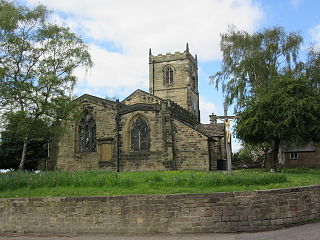
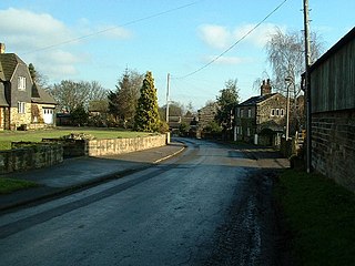
Brierley is a village in the Metropolitan Borough of Barnsley in South Yorkshire, England. The settlement is tightly clustered and green buffered on a modest escarpment close to the border with West Yorkshire, it is almost wholly in population south of the A628 road, and is less than 2 miles (3 km) to the south west of Hemsworth.

Shafton is a civil parish in the Metropolitan Borough of Barnsley in South Yorkshire, England, on the border with West Yorkshire. At the 2001 census it had a population of 2,840, increasing to 3,447 at the 2011 Census. The parish contains the villages of Shafton and Shafton Two Gates.

Kexbrough is a village in the Barnsley district, in the county of South Yorkshire, England, on the border with West Yorkshire. The village falls within the Darton West ward of Barnsley MBC. It is located west of the M1 motorway, just south of Junction 38 at an elevation of around 351 feet (107 m) above sea level. Historically the village was known as Kexborough, and includes the hamlets of Haigh and Swithin. Until 1974 it was in the West Riding of Yorkshire.

Wales is a village and a civil parish in the Metropolitan Borough of Rotherham in South Yorkshire, England. Historically part of the West Riding of Yorkshire, it borders to the south Derbyshire and is astride the M1 motorway. The civil parish of Wales, which has a population of 6,455, increasing to 7,069 at the 2011 Census, encompasses the village and neighbouring settlement Kiveton Park.

Hoyland is a town in the Metropolitan Borough of Barnsley in South Yorkshire, England. The town developed from the hamlets of Upper Hoyland, Hoyland, and Hoyland Common.

Cannon Hall is a country house museum located between the villages of Cawthorne and High Hoyland some 5 miles (8 km) west of Barnsley, South Yorkshire, England. Originally the home of the Spencer and later the Spencer-Stanhope family, it now houses collections of fine furniture, paintings, ceramics and glassware. It at one time housed the Regimental Museum of the 13th/18th Royal Hussars and the Light Dragoons, which has now closed. Now occupying four rooms in the east wing is the "Family of Artists" exhibition on loan from the De Morgan Foundation, which draws on the links between the Spencer Stanhopes and the De Morgans.

Ecclesfield is a village and civil parish in the City of Sheffield, South Yorkshire, England, about 4 miles (6 km) north of Sheffield City Centre. Ecclesfield civil parish had a population of 32,073 at the 2011 Census. Ecclesfield wards of the City of Sheffield had a population of 35,994 in 2011. The population of Ecclesfield village stood at 7,163 in the most recent census.

Silkstone is a village and civil parish in the Metropolitan Borough of Barnsley in South Yorkshire, England. It is situated in the foothills of the Pennines, between the towns of Barnsley and Penistone. The parish includes the village of Silkstone Common. At the 2001 census it had a population of 2,954, increasing to 3,153 at the 2011 Census.

Thurgoland is a village and civil parish in the Metropolitan Borough of Barnsley in South Yorkshire, England, on the A629 road. According to the 2001 census the parish had a population of 1,801, increasing to 1,969 at the 2011 Census.

Clayton West is a village in the parish of Denby Dale, in Kirklees, West Yorkshire, England. It had a population of 2,704 in 2008. It is 11 miles (18 km) south-east of Huddersfield and 7 miles (11 km) north-west of Barnsley.

Staincross was a Wapentake, which is an administrative division, in the historic county of the West Riding of Yorkshire. It consisted of seven parishes, and included the towns of Barnsley and Penistone
Willerby is a village and civil parish located on the western outskirts of the city of Kingston upon Hull in the East Riding of Yorkshire, England.
Bolton upon Dearne is a village in the Metropolitan Borough of Barnsley, South Yorkshire, England, in the part of the Dearne Valley through which the River Dearne passes. Historically part of the West Riding of Yorkshire, it is approximately 7 miles (11 km) east of Barnsley, 10 miles (16 km) west of Doncaster and 8 miles (13 km) north of Rotherham.

Hoylandswaine is a village in the civil parish of Penistone, in the Barnsley district, in the county of South Yorkshire, England. In 2021 it had a population of 1038. Until 1974 it was in the West Riding of Yorkshire.
Woolley is a village and civil parish in the City of Wakefield in West Yorkshire, England. It had a population of 575 in 2001, which increased to 1,339 at the 2011 Census. It is 6 miles (10 km) north of Barnsley, and 7 miles (11 km) south of Wakefield.

North Elmsall is a village in the civil parish of Upton and North Elmsall, in the City of Wakefield district in West Yorkshire, England. The parish had a population of 4,093 in 2001 and 3,873 in 2011. Until 1974 it was part of Hemsworth Rural District. The parish is seven miles from Pontefract, nine miles from Barnsley and Doncaster, and eleven miles from Wakefield.

