Silkstone

Last updated

Silkstone
Village and civil parish
Silkstone Church.jpg
Church of All Saints, Silkstone
South Yorkshire UK location map.svg
Red pog.svg
Silkstone
Location within South Yorkshire
Population3,153 (2011)
OS grid reference SE289058
Civil parish
  • Silkstone
Metropolitan borough
Metropolitan county
Region
Country England
Sovereign state United Kingdom
Post town Barnsley
Postcode district S75
Dialling code 01226
Police South Yorkshire
Fire South Yorkshire
Ambulance Yorkshire
UK Parliament
Website http://www.silkstoneparishcouncil.gov.uk/
List of places
UK
England
Yorkshire
53°32′56″N1°33′48″W / 53.5489°N 1.5634°W / 53.5489; -1.5634 Coordinates: 53°32′56″N1°33′48″W / 53.5489°N 1.5634°W / 53.5489; -1.5634

Silkstone is a village and civil parish in the Metropolitan Borough of Barnsley in South Yorkshire, England. It is situated in the foothills of the Pennines, between the towns of Barnsley and Penistone. The parish includes the village of Silkstone Common. At the 2001 census it had a population of 2,954, [1] increasing to 3,153 at the 2011 Census. [2]

Contents

Silkstone Parish is twinned with Saint-Florent-des-Bois in France.

History

The name Silkstone is Old English in origin and is thought to derive from the Anglo-Saxon man's name Sylc and the suffix tūn meaning a farmstead, giving "Sylc's farmstead". [3] The earliest known written record of Silkstone is the Domesday Book of 1086, when Silkstone is referred to as a part of the manor of Cawthorne:

In Calthorne (Cawthorne) Ailric had three carucates of land to be taxed and there may be two ploughs there. The same now has it of Ilbert; himself two ploughs there, and four villanes with two ploughs. There is a vicor and a church, wood pasture two miles long and two broad; the whole manor three miles long and two broad. Value in King Edward's time forty shillings, now twenty shillings. To this manor belongs Silchestone, one carucate and a half.

The church mentioned may be a predecessor of the current Church of All Saints, the parish church in Silkstone. [4] Silkstone parish originally included Cawthorne, West Bretton, Cumberland, Barnsley, Dodworth, Stainborough, Thurgoland, and Hoylandswaine.

The Silkstone coal seam is at its shallowest in the Silkstone area, and mining was an important local industry. In 1809 the Silkstone Waggonway was built through the village by the Barnsley Canal Navigation Company. [5] The waggonway was used to transport coal from collieries in the Silkstone valley to Cawthorne. A memorial commemorating the waggonway stands in the village. [6]

Sport

The village has sporting facilities, in the shape of the Pavilion. It is host to both a football and cricket team, with both sports being played at junior and senior levels. Silkstone is frequented by ramblers as many walking routes start from the village.

Culture and attractions

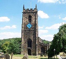
The Church of All Saints was constructed in the 12th century (with alterations/renovations in the 15th and 19th centuries), it is a Grade I listed building. [7] It is locally known as the minster of the moors. The Grade II listed Noblethorpe Hall near the village was built in the early 19th century for the Clarke family (local colliery owners). [8] During the Second World War it was used as an army camp.[ citation needed ] Pot House Hamlet is located below Silkstone Church and was the site of an 18th-century pottery and 17th century glassworks.[ citation needed ] English Heritage have deemed this an underground national ancient monument. [9] Pot House Hamlet today houses many independent retail outlets.

One of the village's famous sons was John Charles Brooke, Esq, FSA (1748–1794) who became Somerset Herald in 1777. He was crushed to death in a crowd at the Haymarket Theatre in London on 3 February 1794.

The Silkstone Wagonway Memorial Wagonway silkstone.jpg
The Silkstone Wagonway Memorial

The Wagonway runs through Silkstone to the neighbouring village Cawthorne, and was used as a route for the transportation of coal from the nearby mines. The sleeper stones were originally laid in the early 19th century when coal mining was booming, and the wagonway was used until the 20th century.[ citation needed ] The stones can still be seen from the Ring O Bells pub to Pot House Hamlet. Today, the Wagonway is a scenic route ideal for country walks, with story boards, and is preserved as a historic route as part of the village's history.

The village is also home to "Old Silkstone Band" brass band. The band has a long history dating back almost 150 years.[ citation needed ] In recent times[ when? ], the band has been very successful, competing for the first time in the championship section, against more famous bands like Grimethorpe and Black Dyke. The band is run without major sponsorship, and is well supported by the villages of Silkstone and Silkstone Common.

Silkstone Common

Silkstone Common has Junior and Infants Schools, a railway station, a single local shop and the Station Inn.

One of the most notable events in the history of the village was the Huskar Pit Disaster, which occurred on 4 July 1838 when a freak storm flooded part of the mine, killing 26 children, the youngest was 7 years, the oldest 17. A historical account of this event has been documented in the book entitled Children of the Dark.

Notable buildings include Knabbe's Hall which was built in the late 17th century for William and Elizabeth Wood of Wortley Forge. [10]

Silkstone Common house prices are high due to the local amenities and close proximity to Penistone Grammar School.

See also

Related Research Articles

<span class="mw-page-title-main">West Bretton</span> Village and civil parish in West Yorkshire, England

West Bretton is a village and civil parish in the City of Wakefield in West Yorkshire, England. It lies 7 miles (11 km) from Wakefield, 8 miles (13 km) from Barnsley, 9 miles (14 km) from Dewsbury, and 11 miles (18 km) from Huddersfield, close to junction 38 of the M1 motorway. It has a population of 546, reducing to 459 at the 2011 Census.

<span class="mw-page-title-main">Kirkburton</span> Village and civil parish in West Yorkshire, England

Kirkburton is a village, civil parish and ward in Kirklees in West Yorkshire, England. It is 5 miles (8 km) south-east of Huddersfield. Historically part of the West Riding of Yorkshire, the township comprises the villages of Kirkburton and Highburton and several hamlets, including Thunder Bridge, Thorncliffe, Storthes Hall, Burton Royd, Riley, Dogley, Common Side, Causeway Foot, Lane Head and Linfit. According to the 2011 census the civil parish had a population of 26,439, while the village itself had a population of 4,299.

<span class="mw-page-title-main">Barnsley</span> Town in South Yorkshire, England

Barnsley is a market town in South Yorkshire, England. As the main settlement of the Metropolitan Borough of Barnsley and the fourth largest settlement in South Yorkshire. In Barnsley, the population was 96,888 while the wider Borough has seen an increase of 5.8%, from 231,200 in 2011 census to 244,600 in 2021 census. Historically in the West Riding of Yorkshire, it is located between the cities of Sheffield, Manchester, Doncaster, Wakefield, and Leeds. The larger towns of Rotherham and Huddersfield are nearby.

<span class="mw-page-title-main">Penistone</span> Town and civil parish in South Yorkshire, England

Penistone is a market town and civil parish in the Metropolitan Borough of Barnsley, South Yorkshire, England, which had a population of 22,909 at the 2011 census. Historically in the West Riding of Yorkshire, it is 8 miles (13 km) west of Barnsley, 17 miles (27 km) north-east of Glossop, 14.2 miles (23 km) north-west of Sheffield, 27 miles (43 km) south-west of Leeds and 29 miles (47 km) east of Manchester in the foothills of the Pennines. The town is frequently noted on lists of unusual place names.

<span class="mw-page-title-main">Grimethorpe</span> Village in South Yorkshire, England

Grimethorpe is a large village in the metropolitan borough of Barnsley in South Yorkshire, England. Historically within the West Riding of Yorkshire, it had a population of 4,672 at the 2011 census. Grimethorpe is located to the east of Barnsley and south of Hemsworth; until the local government reorganisation of 1974, it was part of the Hemsworth district and constituency. At the 2011 Census the village was part of the North East ward of Barnsley MBC.

<span class="mw-page-title-main">Worsbrough</span> Area in South Yorkshire, England

Worsbrough is an area about two miles south of Barnsley in the metropolitan borough of Barnsley, South Yorkshire, England. Before 1974, Worsbrough had its own urban district council in the West Riding of the historic county of Yorkshire and it is still counted as a separate place from Barnsley by the 2011 Census, but it is often treated as part of Barnsley as the two settlements run into one another.

<span class="mw-page-title-main">Dodworth</span> Village in South Yorkshire, England

Dodworth is a village in the metropolitan borough of Barnsley in South Yorkshire, England. Historically part of the West Riding of Yorkshire, it has a population of 5,742, increasing to 5,900 at the 2011 Census.

<span class="mw-page-title-main">Cawthorne</span> Village and civil parish in South Yorkshire, England

Cawthorne is a village and civil parish in the Metropolitan Borough of Barnsley, South Yorkshire, England. The village was once a centre of the iron and coal mining industry; today it is part of an affluent commuter belt west of Barnsley. At the 2001 census it had a population of 1,108, increasing to 1,151 at the 2011 Census.

Silkstone Common is a village in the metropolitan borough of Barnsley in South Yorkshire, England.

<span class="mw-page-title-main">Silkstone Common railway station</span> Railway station in South Yorkshire, England

The present Silkstone Common railway station, which opened by British Rail on 14 May 1983 serves the village of Silkstone Common, near Barnsley in South Yorkshire, England. The station is 3 miles (4.8 km) west of Barnsley on the Penistone Line between Huddersfield and Sheffield.

<span class="mw-page-title-main">Thurgoland</span> Village and civil parish in South Yorkshire, England

Thurgoland is a village and civil parish in the Metropolitan Borough of Barnsley in South Yorkshire, England, on the A629 road. According to the 2001 census the parish had a population of 1,801, increasing to 1,969 at the 2011 Census.

<span class="mw-page-title-main">Staincross Wapentake</span> Former division of the West Riding of Yorkshire, England

Staincross was a Wapentake (Hundred), which is an administrative division, in the historic county of the West Riding of Yorkshire. It consisted of seven parishes, and included the towns of Barnsley and Penistone

Shepley is a village in the civil parish of Kirkburton, in Kirklees, West Yorkshire, England, and in the Diocese of Wakefield. It lies 8 miles (13 km) south south east of Huddersfield and 6 miles (9.7 km) north west of Penistone.

<span class="mw-page-title-main">Midhopestones</span> Village in South Yorkshire, England

Midhopestones is a village in the civil parish of Bradfield within the Stocksbridge and Upper Don electoral ward in the borough of the City of Sheffield, England.

<span class="mw-page-title-main">St James' Church, Midhopestones</span>

St James’ Church, Midhopestones is situated in the small rural hamlet of Midhopestones, just within the northern boundary of the City of Sheffield in South Yorkshire. Since April 1969 it has been a Grade II* listed building. St James is small church which is often referred to as a chapel, in fact it is situated on Chapel Lane. The church is officially dedicated to James the Less and not James the Greater although there has always been some confusion. Some modern historians and clergy maintain that the church should be dedicated to James the Greater as the scallop shells carved above the church door are the traditional emblem of James the Greater. It is possible that it was re-dedicated to James the Less in the Victorian era because of the smallness of the church. The church is in the Parish of Penistone within the Diocese of Wakefield.

<span class="mw-page-title-main">Huskar Pit</span> Former coal mine in South Yorkshire, England

Huskar Pit was a coal mine on the South Yorkshire Coalfield, sunk to work the Silkstone seam. It was located in Nabs Wood, outside the village of Silkstone Common, in the then West Riding of Yorkshire. It was connected to the Barnsley Canal by the Silkstone Waggonway. Huskar was the scene of a notorious pit disaster in 1838.

The Silkstone Waggonway was a narrow-gauge industrial wagonway serving the Barnsley Canal, in England, at Silkstone in South Yorkshire.

Penistone East is a ward in the metropolitan borough of Barnsley, South Yorkshire, England. The ward contains three listed buildings that are recorded in the National Heritage List for England. Of these, one is listed at Grade II*, the middle of the three grades, and the others are at Grade II, the lowest grade. The ward is to the west of the town of Barnsley, and is entirely rural. The listed buildings consist of a former manor house and associated structures converted for residential use, a memorial obelisk and a lodge in the grounds of Wentworth Castle, and a former canal aqueduct.

Silkstone is a civil parish in the metropolitan borough of Barnsley, South Yorkshire, England. The parish contains 23 listed buildings that are recorded in the National Heritage List for England. Of these, one is listed at Grade I, the highest of the three grades, one is at Grade II*, the middle grade, and the others are at Grade II, the lowest grade. The parish contains the villages of Silkstone and Silkstone Common, and the surrounding countryside. The most important building in the parish is All Saints Church, which is listed, together with graveslabs, a tomb, and a memorial in the churchyard. The other listed buildings are houses and cottages, farmhouses and farm buildings, a war memorial, and a set of stocks.

References

  1. Census 2001 Archived 22 December 2016 at the Wayback Machine
  2. "Civil Parish population 2011". Neighbourhood Statistics. Office for National Statistics. Retrieved 5 March 2016.
  3. Goodall, Armitage C. (1913). "Silkstone". Place-Names of South-West Yorkshire; that is, of so much of the West Riding as lies south of the Aire from Keighley onwards. Cambridge: University Press. p.  256.
  4. Hunter, Joseph (1831). South Yorkshire. The history and topography of the deanery of Doncaster, in the diocese and county of York. Volume II. London: J.B. Nichols and Son.
  5. "Silkstone Waggonway Trail". Silkstone Parish. Retrieved 30 December 2006.
  6. "Silkstone Waggonway Memorial". PMSA National Recording Project – South Yorkshire. Public Art Research Archive, Sheffield Hallam University . Retrieved 8 April 2007.
  7. Historic England. "Church of All Saints (1151740)". National Heritage List for England . Retrieved 30 December 2006.
  8. Historic England. "Noblethorpe Hall (1286255)". National Heritage List for England . Retrieved 1 February 2008.
  9. No 35494 authorised by the Secretary of State for Culture, Media and Sport on 12 June 2003.
  10. Historic England. "Knabbe's Hall (1314749)". National Heritage List for England . Retrieved 1 February 2008.