
Cape Cod is a geographic cape extending into the Atlantic Ocean from the southeastern corner of mainland Massachusetts, in the northeastern United States. Its historic, maritime character and ample beaches attract heavy tourism during the summer months.

Provincetown is a New England town located at the extreme tip of Cape Cod in Barnstable County, Massachusetts, in the United States. A small coastal resort town with a year-round population of just under 3,000, Provincetown has a summer population of as high as 60,000. Often called "P-town" or "P'town", the town is known for its beaches, harbor, artists, tourist industry, and its status as a vacation destination for the LGBT+ community.

Truro is a town in Barnstable County, Massachusetts, United States, comprising two villages: Truro and North Truro. Located slightly more than 100 miles (160 km) by road from Boston, it is a summer vacation community just south of the northern tip of Cape Cod, in an area known as the "Outer Cape". English colonists named it after Truro in Cornwall, United Kingdom.

Provincetown Harbor is a large natural harbor located in the town of Provincetown, Massachusetts. The harbor is mostly 30 to 90 feet deep and stretches roughly 1 mile (1.6 km) from northwest to southeast and 2 miles (3.2 km) from northeast to southwest – one large, deep basin with no dredged channel necessary for boats to enter and exit.

Cape Cod Bay is a large bay of the Atlantic Ocean adjacent to the U.S. state of Massachusetts. Measuring 604 square miles (1,560 km2) below a line drawn from Brant Rock in Marshfield to Race Point in Provincetown, Massachusetts, it is enclosed by Cape Cod to the south and east, and Plymouth County, Massachusetts, to the west. To the north of Cape Cod Bay lie Massachusetts Bay and the Atlantic Ocean. Cape Cod Bay is the southernmost extremity of the Gulf of Maine. Cape Cod Bay is one of the bays adjacent to Massachusetts that give it the name Bay State. The others are Narragansett Bay, Buzzards Bay, and Massachusetts Bay.

Donald Baxter MacMillan was an American explorer, sailor, researcher and lecturer who made over 30 expeditions to the Arctic during his 46-year career. He pioneered the use of radios, airplanes, and electricity in the Arctic, brought back films and thousands of photographs of Arctic scenes, and put together a dictionary of the Inuktitut language.

Provincetown Municipal Airport is a public airport located at the end of Cape Cod, two miles (3 km) northwest of the central business district of Provincetown, in Barnstable County, Massachusetts, United States. This airport is operated by the Town of Provincetown on land leased from the U.S. National Park Service.

Elvira's Haunted Hills is a 2001 American comedy horror film directed by Sam Irvin and written by Cassandra Peterson and John Paragon. It is the second film starring Peterson in the title role, after the 1988 theatrical release Elvira: Mistress of the Dark. The film also stars Richard O'Brien and Mary Scheer.
A telegraph hill is a hill or other natural elevation that is chosen as part of an optical telegraph system.

Nauset Regional High School is an NEASC accredited high school located in Eastham, Massachusetts, United States and a part of Nauset Public Schools. Nauset is inside the Cape Cod National Seashore, making it the only high school on the East Coast located within a National Park. The open campus is situated about a half-mile from Nauset Light. Nauset's colors are Black and Gold and the school's mascot is the Warrior.

Provincetown station was located on Bradford Street between Alden and Standish Streets in Provincetown, Massachusetts.

Provincetown Public Schools, also known as Provincetown School District, or Provincetown IB Schools, is the school district of Provincetown, Massachusetts, serving grades Kindergarten through 8.
Sarah K. Peake is an American politician from the Commonwealth of Massachusetts. A Democrat, she has served in the Massachusetts House of Representatives since 2007. She represents the Fourth Barnstable district, a Cape Cod district that includes her hometown of Provincetown. She previously served on the Provincetown Board of Selectmen.
Diman Regional Vocational Technical High School is a public vocational high school located in Fall River, Massachusetts. The high school serves a regional school district comprising the city of Fall River, and the surrounding towns of Somerset, Swansea and Westport. The school has an enrollment of over 1,400 students and offers vocational technical programs in 18 different programs, including Automotive Collision, Repair, and Refinishing; Auto Technology; Building and Property Maintenance; Business Technology; Carpentry-Cabinetmaking; Culinary Arts; Dental Assisting; Drafting; Electricity; Electronics; Graphic Communication; Health Assisting; Heating, Ventilation, Conditioning, and Refrigeration; Machine Tool Technology;Medical Assisting; Metal Fabrication & Joining Technology; Plumbing; Programming and Web development.
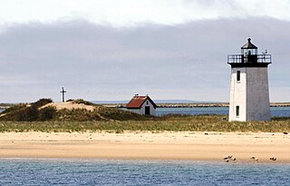
Long Point is a peninsula located in Provincetown, Massachusetts, at the extreme tip of Cape Cod, as it curls back in on itself to create Provincetown Harbor. The Long Point Light was built on this point in 1827. The lighthouse once shared this peninsula with a settlement of fishermen that came to be known as Long Point, Massachusetts. This Provincetown village grew and thrived from 1818 until the late 1850s. When the settlers decided to leave Long Point, they took most of their houses with them – about 30 structures in all – by floating them across the harbor.
Jillian Leigh Bell is an American comedian, actress, and screenwriter. She stars in the 2019 film Brittany Runs a Marathon. She starred as Jillian Belk on Workaholics and had a recurring role as Dixie on the final season of Eastbound & Down, and appeared in 22 Jump Street,Fist Fight, and Godmothered.

Mount Gilboa is a mountain in Barnstable County, Massachusetts. It is 1.8 miles (2.9 km) northeast of Provincetown in the Town of Provincetown. High Pole Hill is located west-southwest and Mount Ararat is located northeast of Mount Gilboa.

Josephine Del Deo, born Josephine Alice Couch, was an American artist, writer, and activist in preserving the Cape Cod National Seashore and the town of Provincetown, Massachusetts.
Nauset Public Schools, or the Nauset Regional School District, is a school district headquartered in Orleans, Massachusetts. In addition to Orleans its attendance area includes Brewster, Eastham, and Wellfleet.

