Related Research Articles

Ernakulam is one of the 14 districts in the Indian state of Kerala, and takes its name from the eponymous city division in Kochi. It is situated in the central part of the state, spans an area of about 2,924 square kilometres (1,129 sq mi), and is home to over 9% of Kerala's population. Its headquarters are located at Kakkanad. The district includes Kochi, also known as the commercial capital of Kerala, which is famous for its ancient churches, Hindu temples, synagogues and mosques.
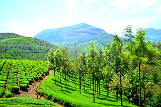
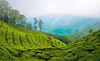
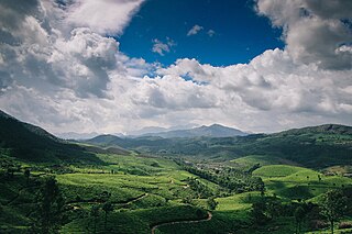
Munnar is a town and hill station located in the Idukki district of the southwestern Indian state of Kerala. Munnar is situated at around 1,600 metres (5,200 ft) above mean sea level, in the Western Ghats mountain range. Munnar is also called the "Kashmir of South India" and is a popular honeymoon destination.

Idukki is one of the 14 districts in the Indian state of Kerala in the southwest of the country. It is the largest district in Kerala and lies amid the Cardamom Hills of Western Ghats in Kerala. Idukki district contains two municipal towns – Kattappana and Thodupuzha, and five taluks.

Muvattupuzha is a municipality in the Ernakulam district of Kerala, India. It is located 26 km (16.2 mi) east of the district headquarters in Thrikkakara and about 170 km (105.6 mi) north of the state capital Thiruvananthapuram. As per the 2011 Indian census, Muvattupuzha has a population of 30,397 people, and a population density of 2,306/km2 (5,970/sq mi).
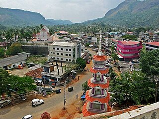
Mundakayam, is a town in Kanjirappally Taluk in the Kottayam District of Kerala. It is the doorway to the high ranges of southern Kerala, and is at the border of Kottayam and Idukki districts. The next nearest town, Kanjirappally, is 14 km (8.7 mi) & Erumely is 12 km from Mundakayam. Mundakayam has rubber plantations, and greenery. The Manimala River runs through Mundakayam. It is located 48 km east of the district headquarters at Kottayam and 148 km from the state capital, Thiruvananthapuram. The name Mundakayam is said to be derived from the Mundi cranes that used to be seen along the Manimala River banks.
Thekkady is a town near Periyar National Park, an important tourist attraction in the Kerala state of India. The name Thekkady is derived from the word "thekku" which means teak. Temperatures are lowest in the months of December–January and highest in the months of April–May.
The Cardamom Hills or Yela Mala are mountain range of southern India and part of the southern Western Ghats located in Idukki district, Kerala, India. Their name comes from the cardamom spice grown in much of the hills' cool elevation, which also supports pepper and coffee. The Western Ghats and Periyar Sub-Cluster including the Cardamom Hills are UNESCO World Heritage Sites.

Periyar, is the longest river and the river with the largest discharge potential in the Indian state of Kerala. It is one of the few perennial rivers in the region and provides drinking water for several major towns. The Periyar is of utmost significance to the economy of Kerala. It generates a significant proportion of Kerala's electrical power via the Idukki Dam and flows along a region of industrial and commercial activity. The river also provides water for irrigation and domestic use throughout its course besides supporting a rich fishery. Due to these reasons, the river has been named the "Lifeline of Kerala". Kochi city, in the vicinity of the river mouth, draws its water supply from Aluva, an upstream site sufficiently free of seawater intrusion. Twenty five percent of Kerala's industries are along the banks of the Periyar. These are mostly crowded within a stretch of 5 kilometres (3 mi) in the Eloor-Edayar region (Udhyogamandal), about 10 kilometres (6 mi) north of Kochi harbor.

The Anamala or Anaimalai, also known as the Elephant Mountains, are a range of mountains in the southern Western Ghats of central Kerala and span the border of western Tamil Nadu in Southern India. The name anamala is derived from the Malayalam word aana and the Tamil word yaanai, meaning elephant, or from tribal languages. Mala or Malai means 'mountain', and thus literally translatable as 'Elephant mountain'.

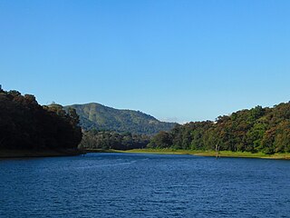
Periyar National Park and Wildlife Sanctuary (PNP) is a protected area located in the districts of Pathanamthitta and Idukki in Kerala, India. It is a renowned Elephant and Tiger reserve. The protected area encompasses 925 km2 (357 sq mi), of which 305 km2 (118 sq mi) of the main zone was declared as the Periyar National Park in 1982. The park is a repository of rare, endemic, and endangered flora and fauna and forms the major watershed of two important rivers of Kerala: the Periyar and the Pamba.

Kerala is situated between the Lakshadweep Sea to the west and the Western Ghats to the east. Kerala's coast runs some 590 km in length, while the state itself varies between 35–120 km in width. Geologically, pre-Cambrian and Pleistocene formations comprise the bulk of Kerala's terrain. The topography consists of a hot and wet coastal plain gradually rising in elevation to the high hills and mountains of the Western Ghats. Kerala lies between northern latitude of 8°.17'.30" N and 12°. 47'.40" N and east longitudes 74°.27'.47" E and 77°.37'.12" E. Kerala's climate is mainly wet and maritime tropical, heavily influenced by the seasonal heavy rains brought up by the monsoon Weather.

Peermade, also spelt Peerumedu is a village, Grama Panchayat and hill station in the state of Kerala, in southwestern India. It lies 915 metres (3,002 ft) above sea level in the Western Ghats (Sahyadri) about 85 kilometres (53 mi) east of Kottayam on the way to Thekkady through the nearby city of Kanjirappally.
Kattappana ([kaʈ:ap:ɐna]) is a municipality in the Idukki district of Kerala, India. It is located 21 km (13.0 mi) southeast of the district headquarters in Painavu and about 140 km (87.0 mi) north of the state capital, Thiruvananthapuram. Kattappana is the second-largest municipality in the district by population, and serves as a major hub for commercial and economic activity for the surrounding region.

Aryankavu is a village located in the Kollam district of the Indian state of Kerala. It lies close to the border between Kerala and Tamil Nadu near Thenmala. It is also one of the famous pilgrimage sites associated with the legend of Sabarimala. The village is located beside Shendurney Wildlife Sanctuary.
Nedumkandam is the headquarters of Udumbanchola taluk which is situated in Idukki district of the Indian state of Kerala. Nedumkandam is among the fastest growing towns in the Idukki district. Nedumkandam is well known for its spices production and is a major contributor to the production of spices like cardamom and pepper. This town situated an average elevation of 900 meter above sea level and maximum elevation respectively 1190 meter 1100 meter and 975 meter and is a destination for economical stay and shopping for tourists in the popular Kumily-Munnar tourist route.
Adimali is a town in the Idukki district of Kerala, in southwesternIndia. National Highway 185 is a highway in India running from Adimali to Kumily through Kattappana and ends in Adoor in Kerala. Adimaly is located on the National Highway 49, now NH 85, known as Kochi-Dhanushkodi National Highway, earlier known as the Kochi Madhura Highway (India) connecting Kochi and Madurai, India. From Adimaly, it is only 27 kilometers to Munnar, which is a famous hill station. The waterfalls Cheeyappara, Adimali waterfalls and Valara are located nearby. Pepper and cocoa cultivation is the main agricultural activity of this place. The Ponmudi Dam was constructed in 1963 across the Panniar river, nearly 15 km southeast of Adimali, on the way to Rajakkad.Thopramkudy is the nearest town. Adimali is known for its proximity to Munnar and natural environment. Adimali has almost all the basic facilities like roads, super markets, markets, educational institutions and hospitals.

Anakkara is a geographic area of around 50 square kilometres that spans across Vandanmedu, Chakkupallam Panchayats in the Udumbanchola Taluk of Idukki District. Anakkara is the administrative capital of Chakkupallam Grama Panchayat and Anakkara Revenue Village. Situated at about 18 kilometers (11 mi) from Thekkady wildlife sanctuary on the Kumily-Munnar state highway, Anakkara is a fast-growing tourist destination for its unique spice gardens and many picnic spots in and around. It is one of the 36 distinct places identified by Government of India and United Nations Development Programme for exploring and promoting the unique tourism potential of these places.
Suryanelli is a resort settlement in the Chinnakanal village in Idukki district, Kerala, India. Situated 40 km southeast of Munnar. It is surrounded by tea plantations and several resorts.

Kolukkumalai is a small village/hamlet in Bodinayakanur Taluk in the Theni district of the Indian state of Tamil Nadu. It is home to the highest tea plantation in the world with the tea grown here possessing a special flavour and freshness because of the high altitude. It is located near Munnar in Idukki district of Kerala.

The KDHP Tea Museum is an industry and history museum situated in Munnar, a town in the Idukki district of Kerala in South India. Tata Tea Museum is its official name, but it's also known as Nullathanni Estate where it is located, or Kannan Devan Hills Plantation (KDHP) Tea Museum.
References
- ↑ The Modern Review. Prabasi Press Private, Limited. 1955.
- ↑ Guides, Rough (2010). The Rough Guide to Kerala. Rough Guides UK. ISBN 978-1-4053-8804-7.
- ↑ Nair, Sathis Chandran (1994). The High Ranges: Problems & Potential of a Hill Region in the Southern Western Ghats. Indian National Trust for Art and Cultural Heritage. ISBN 978-81-900281-3-4.
- ↑ Stott, David (2014). Kerala Footprint Focus Guide: Includes Kochi, Alappuzha, Thrissur, Periyar, River Nila. Footprint Travel Guides. ISBN 978-1-909268-79-1.
- ↑ "History of Munnar, Hill station, Plantation era, Idukki, Kerala, India". Kerala Tourism - Munnar. Retrieved 23 October 2021.
- ↑ "Memorial for Irish planter who brought rubber to India". Business Standard India. Press Trust of India. 30 September 2010. Retrieved 23 October 2021.
- ↑ "Gadgil Report" (PDF). Centre for Public Policy Research .
- ↑ "J J Murphy: Kerala's Rubber Man". Live History India. Retrieved 23 October 2021.
- ↑ Jaikrishnan Nair (20 October 2021). "koottickal: Kerala: Study had warned against mining in Kootickal hills | Kochi News - Times of India". The Times of India. Retrieved 23 October 2021.
| | This article related to a location in Kerala is a stub. You can help Wikipedia by expanding it. |