Related Research Articles

Chouteau County is a county located in the North-Central region of the U.S. state of Montana. As of the 2020 census, the population was 5,895. Its county seat is Fort Benton. The county was established in 1865 as one of the original nine counties of Montana, and named in 1882 after Pierre Chouteau Jr., a fur trader who established a trading post that became Fort Benton, which was once an important port on the Missouri River.
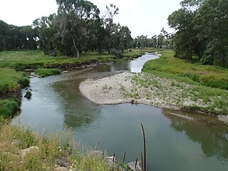
The Judith River is a tributary of the Missouri River, approximately 124 mi (200 km) long, running through central Montana in the United States. It rises in the Little Belt Mountains and flows northeast past Utica and Hobson. It is joined by Dry Wolf Creek in northern Fergus County, and itself joins the Missouri in the White Cliffs Area approximately 18 mi (29 km) northwest of Winifred.

Custer National Forest is located primarily in the south central part of the U.S. state of Montana but also has separate sections in northwestern South Dakota. With a total area of 1,188,130 acres (4,808 km2), the forest comprises over 10 separate sections. While in the westernmost sections, Custer National Forest is a part of the Greater Yellowstone Ecosystem, the easternmost sections are a combination of forest "islands" and grasslands. A portion of the forest is also part of the Absaroka-Beartooth Wilderness and constitutes over a third of the wilderness land. South of Red Lodge, Montana, the Beartooth Highway passes through the forest en route to Yellowstone National Park.
Lewis and Clark National Forest is located in west central Montana, United States. Spanning 2,912 square miles (7,500 km2). The region was inhabited by various cultures of Native Americans for a period of at least 8,000–10,000 years. When the Lewis and Clark Expedition came to this area, different areas of the large forest territory were used by members of the Blackfeet, Sioux, Cheyenne, Flathead and Crow nations for hunting and as an area for their seasonal winter camps. The forests provided shelter from the winter.

Lolo National Forest is a national forest located in western Montana, United States with the western boundary being the state of Idaho. The forest spans 2 million acres (8,000 km2) and includes four wilderness areas; the Scapegoat and the Selway-Bitterroot Wilderness are partially within the forest while the Welcome Creek and Rattlesnake Wildernesses are solely in Lolo National Forest. The forest was created in 1906 from 4 different previous forests which were combined for administrative purposes. Lolo National Forest is west of the Continental divide and has a biodiversity influenced by both continental and maritime weather creating a transitional forest that has a high number of different plant and tree species.
The Highwood Mountains are an island range which cover approximately 4,659 km2 of the Central Montana Alkalic Province in north central Montana in the U.S. They are in Chouteau, Judith Basin and Cascade counties and lie east of Great Falls and Benton Lake National Wildlife Refuge, at the northern end of the Lewis and Clark National Forest. The mountains were included in Highwood Mountains National Forest until 1908, when the unit became part of Lewis and Clark National Forest.
Absaroka National Forest is a U.S. national forest in the U.S. state of Montana, established by the United States General Land Office on September 4, 1902, as the Absaroka Forest Reserve with a total area of 1,311,600 acres (5,308 km2).
Crazy Mountain National Forest was established as the Crazy Mountain Forest Reserve in Montana by the U.S. Forest Service on August 10, 1906 with 234,760 acres (950.0 km2). It became a National Forest on March 4, 1907. On July 1, 1908 it was combined with part Yellowstone National Forest to re-establish Absaroka National Forest and its name was discontinued.
Beartooth National Forest was established in Montana on July 1, 1908 by the U.S. Forest Service with 685,293 acres (2,773.28 km2) from part of Yellowstone National Forest and all of Pryor Mountains National Forest. On February 17, 1932 the forest was divided between Absaroka National Forest and Custer National Forest and the name preserved as the Beartooth Ranger District of Custer National Forest.

Pryor Mountains National Forest was established as the Pryor Mountains Forest Reserve by the U.S. Forest Service in Montana on November 6, 1906 by the U.S. Forest Service with 78,732 acres (318.62 km2). It became a National Forest on March 4, 1907. On July 1, 1908 it was combined with part of Yellowstone National Forest to establish Beartooth National Forest. The name was discontinued.
Baboquivari National Forest was established as the Baboquivari Forest Reserve by the U.S. Forest Service in Arizona on November 5, 1906, with 126,720 acres (512.8 km2). On March 4, 1907, it became a National Forest, and on July 1, 1908, the entire forest was combined with Huachuca National Forest and Tumacacori National Forest to establish Garces National Forest. The name was discontinued.

Dragoon National Forest was established in Arizona on May 25, 1907, covering 69,120 acres (280 km2). On July 1, 1908, it was combined with Santa Catalina National Forest and Santa Rita National Forest to create Coronado National Forest. The name was discontinued.
Santa Rita National Forest was established as the Santa Rita Forest Reserve by the United States General Land Office in Arizona on April 11, 1902 with 337,300 acres (1,365 km2). After the transfer of federal forests to the U.S. Forest Service in 1905, it became a National Forest on March 4, 1907. On July 1, 1908 it was combined with Santa Catalina National Forest and Dragoon National Forest to create Coronado National Forest and the name was discontinued.
Little Belt National Forest was established as the Little Belt Forest Reserve by the U.S. Forest Service in Montana on October 3, 1905 with 583,600 acres (2,362 km2) after a name change from Little Belt Mountains Forest Reserve, which was established on August 16, 1902 with 501,000 acres (2,030 km2). It became a National Forest on March 4, 1907. On July 1, 1908 the entire forest was combined with Highwood Mountains, Snowy Mountains and Little Rockies National Forests to establish Jefferson National Forest and the name was discontinued. The lands are included in Lewis and Clark National Forest.
Snowy Mountains National Forest was established as the Snowy Mountains Forest Reserve by the U.S. Forest Service in Montana on November 5, 1906 with 126,080 acres (510.2 km2). It became a National Forest on March 4, 1907. On July 1, 1908 the entire forest was combined with Little Belt, Snowy Mountains and Little Rockies National Forests to establish Jefferson National Forest and the name was discontinued.
Little Rockies National Forest was established by the U.S. Forest Service in Montana on March 2, 1907 with 31,000 acres (130 km2). On July 1, 1908 the entire forest was combined with Little Belt, Snowy Mountains and Highwood Mountains National Forests to establish Jefferson National Forest (Montana) and the name was discontinued. The entire Jefferson National Forest was later consolidated with the Lewis and Clark National Forest. The former Forest Service lands in the Little Rockies are now administered by the Bureau of Land Management.
Jefferson National Forest in Montana was established by the U.S. Forest Service on July 1, 1908 with 1,255,320 acres (5,080.1 km2) from the consolidation of Little Belt, Highwood Mountains, Snowy Mountains and Little Rockies National Forests. On April 8, 1932 the entire forest was transferred to Lewis and Clark National Forest, the name surviving as the Jefferson Division of Lewis and Clark.
Pinal Mountains National Forest was established as the Pinal Mountains Forest Reserve by the U.S. Forest Service in Arizona on March 20, 1905 with 45,760 acres (185.2 km2). It became a National Forest on March 4, 1907 and encompassed the entirety of the Pinal Mountains south of Globe, Arizona and some areas surrounding the mountains. On January 13, 1908 the forest was combined with Tonto National Forest and the name was discontinued.
References
- ↑ Davis, Richard C. (September 29, 2005). "National Forests of the United States" (PDF). The Forest History Society. Archived from the original (PDF) on October 28, 2012.
- ↑ "Maps and Brochures". Lewis and Clark National Forest. U.S. Forest Service. 2008-08-23.
- ↑ "About Us". Lewis and Clark National Forest. U.S. Forest Service. 2008-08-23.