Related Research Articles

Quercus kelloggii, the California black oak or Kellogg oak, is an oak in the red oak section native to western North America. Although genetically separated from them for more than 20 million years, its leaves are remarkably similar in appearance to several other members of the red oak section including the red oak and the black oak found in eastern and central North America.

The Great Plains are a broad expanse of flatland in North America. The region is located just to the east of the Rocky Mountains, much of it covered in prairie, steppe, and grassland. They are the western part of the Interior Plains, which include the mixed grass prairie, the tallgrass prairie between the Great Lakes and Appalachian Plateau, and the Taiga Plains and Boreal Plains ecozones in Northern Canada. "Great Plains", or Western Plains, is also the ecoregion of the Great Plains or alternatively the western portion of the Great Plains.

An arboretum is a botanical collection composed exclusively of trees and shrubs of a variety of species. Originally mostly created as a section in a larger garden or park for specimens of mostly non-local species, many modern arboreta are in botanical gardens as living collections of woody plants and are intended at least in part for scientific study.

The longleaf pine is a pine species native to the Southeastern United States, found along the coastal plain from East Texas to southern Virginia, extending into northern and central Florida. In this area it is also known as "yellow pine" or "long leaf yellow pine", although it is properly just one out of a number of species termed yellow pine. It reaches a height of 30–35 m (98–115 ft) and a diameter of 0.7 m (28 in). In the past, before extensive logging, they reportedly grew to 47 m (154 ft) with a diameter of 1.2 m (47 in). The tree is a cultural symbol of the Southern United States, being the official state tree of Alabama. This particular species is one of the eight pine tree species that falls under the "Pine" designation as the state tree of North Carolina.

The Greater Yellowstone Ecosystem (GYE) is one of the last remaining large, nearly intact ecosystems in the northern temperate zone of the Earth. It is located within the northern Rocky Mountains, in areas of northwestern Wyoming, southwestern Montana, and eastern Idaho, and is about 22 million acres (89,000 km2). Yellowstone National Park and the Yellowstone Caldera 'hotspot' are within it.

The tallgrass prairie is an ecosystem native to central North America. Historically, natural and anthropogenic fire, as well as grazing by large mammals provided periodic disturbances to these ecosystems, limiting the encroachment of trees, recycling soil nutrients, and facilitating seed dispersal and germination. Prior to widespread use of the steel plow, which enabled large scale conversion to agricultural land use, tallgrass prairies extended throughout the American Midwest and smaller portions of southern central Canada, from the transitional ecotones out of eastern North American forests, west to a climatic threshold based on precipitation and soils, to the southern reaches of the Flint Hills in Oklahoma, to a transition into forest in Manitoba.

The Davis Mountains, originally known as Limpia Mountains, are a range of mountains in West Texas, located near Fort Davis, after which they are named. The fort was named for then United States Secretary of War and later Confederate President Jefferson Davis. They are a popular site for camping and hiking and the region includes Fort Davis National Historic Site and Davis Mountains State Park. The historical and architectural value of the fort, alongside the rugged natural environment of the park are a significant destination for tourism in Texas.

The Midewin National Tallgrass Prairie (MNTP) is a tallgrass prairie reserve and is preserved as United States National Grassland operated by the United States Forest Service. The first national tallgrass prairie ever designated in the United States and the largest conservation site in the Chicago Wilderness region, it is located on the site of the former Joliet Army Ammunition Plant between the towns of Elwood, Manhattan and Wilmington in northeastern Illinois. Since 2015, it has hosted a conservation herd of American bison to study their interaction with prairie restoration and conservation.

Bitterroot National Forest comprises 1.587 million acres (6,423 km2) in west-central Montana and eastern Idaho of the United States. It is located primarily in Ravalli County, Montana, but also has acreage in Idaho County, Idaho (29.24%), and Missoula County, Montana (0.49%).
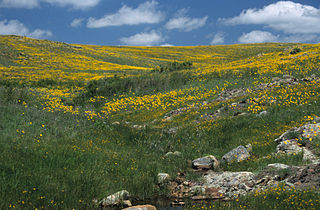
Wichita Mountains Wildlife Refuge, located in southwestern Oklahoma near Lawton, has protected unique wildlife habitats since 1901 and is the oldest managed wildlife facility in the United States Fish and Wildlife Service system. The refuge's location in the geologically unique Wichita Mountains and its areas of undisturbed mixed grass prairie make it an important conservation area. The Wichita Mountains are approximately 500 million years old. Measuring about 59,020 acres (238.8 km2), the refuge hosts a great diversity of species: 806 plant species, 240 species of birds, 36 fish, and 64 reptiles and amphibians are present.

Eldorado National Forest is a U.S. National Forest located in the central Sierra Nevada mountain range, in eastern California.
The Fremont-Winema National Forest of south central Oregon is a mountainous region with a rich geological, ecological, archaeological, and historical history. Founded in 1908, the Fremont National Forest was originally protected as the Goose Lake Forest Reserve in 1906. The name was soon changed to Fremont National Forest, named after John C. Frémont, who explored the area for the United States Army Corps of Engineers in 1843. It absorbed part of Paulina National Forest on July 19, 1915. In 2002, it was administratively combined with the Winema National Forest as the Fremont–Winema National Forests.
Mohawk Trail State Forest is a publicly owned state forest in the U.S. state of Massachusetts with recreational features located in the towns of Charlemont, Hawley, and Savoy. It covers more than 7,700 acres (3,100 ha) of mountain ridges, gorges, and old-growth forests at elevations ranging from around 600 to 2,080 feet. It is managed by the Department of Conservation and Recreation.
The Ventana Wilderness of Los Padres National Forest is a federally designated wilderness area located in the Santa Lucia Range along the Central Coast of California. This wilderness was established in 1969 when the Ventana Wilderness Act redesignated the 55,800-acre (22,600 ha) Ventana Primitive Area as the Ventana Wilderness and added land, totalling 98,000 acres. In 1978, the Endangered American Wilderness Act added 61,000 acres, increasing the total wilderness area to about 159,000 acres. The California Wilderness Act of 1984 added about 2,750 acres. The Los Padres Condor Range and River Protection Act of 1992 created the approximately 14,500-acre (5,900 ha) Silver Peak Wilderness and added about 38,800 acres to the Ventana Wilderness in addition to designating the Big Sur River as a Wild and Scenic River. The Big Sur Wilderness and Conservation Act of 2002 expanded the wilderness for the fifth time, adding nearly 35,000 acres (14,000 ha), increasing the total acreage of the wilderness to its present size of 240,026 acres (97,135 ha).
The Rogue River–Siskiyou National Forest is a United States National Forest in the U.S. states of Oregon and California. The formerly separate Rogue River and Siskiyou National Forests were administratively combined in 2004. Now, the Rogue River–Siskiyou National Forest ranges from the crest of the Cascade Range west into the Siskiyou Mountains, covering almost 1.8 million acres (7,300 km2). Forest headquarters are located in Medford, Oregon.

The Lake George State Forest is a designated protected area and state forest in the U.S. state of Florida. The 21,176-acre (8,570 ha) forest is located in northwestern Volusia County, Florida, near Lake George and the communities of Pierson, Barberville, and Volusia. It is overseen by the Florida Forest Service within the Florida Department of Agriculture and Consumer Services.

The ecology of the Rocky Mountains is diverse due to the effects of a variety of environmental factors. The Rocky Mountains are the major mountain range in western North America, running from the far north of British Columbia in Canada to New Mexico in the southwestern United States, climbing from the Great Plains at or below 1,800 feet (550 m) to peaks of over 14,000 feet (4,300 m). Temperature and rainfall varies greatly also and thus the Rockies are home to a mixture of habitats including the alpine, subalpine and boreal habitats of the Northern Rocky Mountains in British Columbia and Alberta, the coniferous forests of Montana and Idaho, the wetlands and prairie where the Rockies meet the plains, a different mix of conifers on the Yellowstone Plateau in Wyoming, the montane forests of Utah, and in the high Rockies of Colorado and New Mexico, and finally the alpine tundra of the highest elevations.
Geneva State Forest is an Alabama state forest in Geneva County, Alabama in the United States. The forest is 7,120 acres (2,880 ha) and sits at an elevation of 210 feet (64 m). It is Alabama's largest state forest. According to the Alabama Forestry Commission the primary objective of the state forest is to provide timber for the lumber industry and the secondary objectives are to provide habitats for wildlife and recreational opportunities for people. The forest is open for year-round recreation including hunting, fishing, hiking and camping.

American Prairie is a prairie-based nature reserve in Central Montana, United States, on a shortgrass prairie ecosystem with migration corridors and native wildlife. This wildlife conservation area is being developed as a private project of the American Prairie Foundation (APF), a non-profit organization. The reserve covers 462,803 acres (187,290 ha). The organization hopes to expand it greatly through a combination of both private and public lands.
References
- ↑ Davis, Richard C. (September 29, 2005), National Forests of the United States (PDF), The Forest History Society, archived from the original (pdf) on October 28, 2012
- 1 2 "Kansas National Forest". Kansapedia. Kansas Historical Society. Archived from the original on December 16, 2019. Retrieved May 2, 2020.
- ↑ Sandsage Bison Range handout. Kansas Department of Wildlife, Parks and Tourism.
- ↑ "Sandsage Bison Range Wildlife Area". Garden City, Kansas. Retrieved May 2, 2020.
- ↑ "History". Sandsage Bison Range Wildlife Area. Kansas Department of Wildlife, Parks and Tourism. Retrieved May 2, 2020.