In the history of Seattle before white settlement, thirteen prominent villages existed in what is now the city of Seattle. The people living near Elliott Bay, and along the Duwamish, Black and Cedar Rivers were collectively known as the doo-AHBSH, or People of the Doo ("Inside"). Four prominent villages[1] existed near what is now Elliott Bay and the (then-estuarial) lower Duwamish River. Before civil engineers rechanneled the Duwamish, the area had extensive tidelands, and had an abundance of seafoods.[2]
The people living around Lake Washington were collectively known as hah-choo-AHBSH or hah-chu-AHBSH or Xacuabš, People of HAH-choo or Xachu, "People of a Large Lake" or "Lake People". When major European contact began, these people considered themselves related but distinct from the Dkhw'Duw'Absh. The lake drained by the Black River in what is now Renton. The Black River joined the Cedar and White (now Green) rivers to become the Duwamish River and empty into what is now referred to as southeast Elliott Bay.[3] As European contact continued and increased, the hah-choo-AHBSH (Xacuabš) and doo-AHBSH, (Dkhw'Duw'Absh) became identified as the people represented by the Duwamish tribe. The people are Coast Salish, and (Skagit-Nisqually) Lushootseed by language.[4]
The present-day Duwamish Longhouse and Cultural Center, near the historic site of tohl-AHL-too ("herring house")
dzee-dzee-LAH-letch was the most important village on what is now called Elliott Bay, with some 200 people c.1800.[8]Chief Seattle [si'áb Si'ahl] lived here for some time. The village had eight large khwaac'ál'al (longhouses)—each 60 feet by 120 feet (18 m x 37 m)—plus a large potlatch house, where people from all over the area gathered. dzee-dzee-LAH-letch ("little crossing-over place") was located near the trail: appropriately, where the King Street Station was later built. Before the extensive tidelands were filled in, there was a spit here, separating Elliott Bay from a lagoon known for flounder.
tohl-AHL-too ("herring house") and later hah-AH-poos ("where there are horse clams") was on the west bank of the Duwamish River near its former estuarial mouth on Elliott Bay, located around what is now south Harbor Island. This was the original village site that had been inhabited since the 6th century (see also Duwamish tribe#History).[9] It was abandoned sometime before 1800, but there elders reported that the village had seven (60ft by 120ft (37m), 18 m x 37 m) longhouses plus a large (60ft by 360ft (110m), 18 m x 110 m) potlatch house. At the successor village nearby there were three longhouses occupied by 75-100 people.
Three stone "projectile points" and a stone adze blade from Duwamish No. 1 site. Displayed at Duwamish Longhouse and Cultural Center
The Duwamish was a bountiful estuary, a powerful meandering river with extensive tidal flats and wildlife, when pioneer John Pike officially bought the land from the U.S. government in 1860, soon after the Treaty of Point Elliott, 1855. Local shipyards built fishing boats for European immigrants until the resource diminished. The site was being cleared of buildings to construct a marine terminal when archaeological discoveries in 1977 halted further development.[10] This site is in what is now known as Herring House Park (Herring's House Park), just north of Terminal 107 (map ). The site overlooks Kellogg Island and a natural channel of the river. The 17-acre (69,000m2) park contains a natural intertidal basin at the shoreline and areas of marsh, meadow and forest in the upland portion. In season, the park has hundreds of juvenile fish, and migrating salmon which attract harbor seals, ospreys, and bald eagles and provide habitat for cormorants, great blue herons, purple martins and other native waterfowl.[11] Overlooking the park is the Duwamish Longhouse, cultural center of the Duwamish Tribe (above). Above the contemporary Duwamish Longhouse is the restored and partially daylighted watershed of to-AH-wee (trout),[12] now called Longfellow Creek, just over the ridge that is now called Delridge. Puget Creek was the freshwater resource and a seasonal fishery for the village. Much of Puget Park is now a natural area, along with others nearby. Eventually, with ongoing volunteer effort, the surroundings will have restored areas and views.[13]
too-PAHLH-tehb was at the mouth of the easternmost estuary of the Duwamish River, approximately 1st Avenue at Spokane Street.
yee-LEH-khood ("basket cap" like those worn by the Yakama people) was a particularly long-established village on the then-west bank of a bend in the Duwamish River, in what is now Terminal 107 Park, the higher ground of the Port of Seattle terminal.
The kehl-kah-KWEH-yah ("Proud People") had their village at too-KWHEHL-teed ("a large open space") farther upstream at a former bend of the Duwamish, in what is now south Georgetown. The large open space was likely artificially maintained.
Salmon Bay Charlie and Chilohleet'sa's house at Shilshole with a canoe anchored offshore, c.1905.
North of Downtown
The people called shill-shohl-AHBSH had the village of shill-SHOHL ("threading a needle", apparently for the narrow opening out to Puget Sound) on the north shore of what is now named Salmon Bay, where the Ballard Locks were built. (See also SWAH-tsoo-gweel village, just below.)
Along Lake Washington
All the people living around Lake Washington were collectively known as Xacuabš (hah-choo-AHBSH or hah-chu-AHBSH), People of HAH-choo or Xachu, "People of a Large Lake" or "Lake People". Initially, at the time of major European contact, these people considered themselves related but distinct from the Dkhw'Duw'Absh. The lake drained out the Black River in present-day Renton. The Black River joined the Cedar and White (now Green) rivers to become the Duwamish River and empty into what is now called southeast Elliott Bay.[14]
The hah-chu-AHBSH called what is known now as Bailey Peninsula in Seward ParkskEba’kst (skuh-BAHKST, "nose"); the isthmus was cqa'lapsEb (TSKAH-lap-suhb, "neck"). As Lake Washington was then 9 feet (2.7m) higher and the isthmus was only a few hundred feet wide, during seasonal floods the peninsula would become an island. A large wetland and marsh was north of what is now the park entrance circle, at what is now Andrews Bay. The lake, bay, wetlands, and peninsula were richly abundant.
The Xacuabš had a village of two longhouses (khwaac'ál'al, forerunners of sizable cohousing for tens of people in each one) at xaxao'Ltc (ha-HAO-hlch, the "sacred or taboo place", from xá?xa?),[15] at or near what is now Brighton Beach. Villages were diffuse. Other khwaac'ál'al were on the southwest lake shore at SExti'tcb ("by means of swimming", Bryn Mawr), at TL’Ltcus (TLEELH-chus, "little island", Pritchard's Island), and to farther north at Leschi Park.
Besides providing food, the lake was home to powerful spirits. The word xá?xa? also means sacred, great and mighty. The previously mentioned xaxao'lc ("taboo place") at Brighton Beach, south of the peninsula, was named for a supernatural spirit who was said to live in the lake there. The unusual sound of the babbling waters at this place indicated its presence. Near Colman Park lived an ?ya’hos, a horned spirit that was associated with landslides and earthquakes. Remarkably, this is the approximate location of the Seattle Fault, which moved more than 20 feet (6.1m) vertically during an earthquake about 1,100 years ago. This quake caused a landslide at South Point on Mercer Island sending a large section of forest into the lake. Little earth beings were said to inhabit the tree stumps there and drove insane a man while he was trying to harvest the bark from the stumps.[5]
Two villages whose names are unknown were located to the east of Downtown on Lake Washington. One of the possible village sites of the skah-TEHLB-shahbsh was around what was later named Wetmore Slough, now the filled Genesee Park in Columbia City.[16] A second village of the skah-TEHLB-shahbsh was at what is now Leschi Park.
What is now Rainier Beach (Atlantic City Park) is the possible site of one of two skah-TEHLB-shahbsh villages, though the village name is not known.
The influential and principal village of the hloo-weelh-AHBSH was in the vicinity of present-day Brooklyn Avenue, at a then-much larger Portage Bay,[17] and SWAH-tsoo-gweel ("portage") on the north shores of a Union Bay nearly a mile farther than today, near what is now the Burke-Gilman Trail and the southeast corner of Ravenna Park. (What is now the Burke-Gilman Trail was built along the shoreline c.1886 by the Seattle, Lake Shore and Eastern Railway.) Five longhouses were located on the north of the bay. Other longhouses were near the present University of Washington (UW) steam plant (west of the UW IMA Building, and between what is now the Center for Urban Horticulture and present-day Children's Hospital). For this village, their backyard was the neighborhoods of the Ravenna Creek watershed today. In summer, the village largely moved to Sahlouwil, what is now southeast Laurelhurst on Lake Washington.[18]
The village of hehs-KWEE-kweel ("skate") was of the hloo-weelh-AHBSH (from s'hloo-WEELH, "a tiny hole drilled to measure the thickness of a canoe"), for the narrow passage through then-large and resource-rich Union Bay marsh. Traces of the marsh survive as the Union Bay Natural Area and the Foster Island area of north Washington Park Arboretum. The trees and the island of Stitici, (Stee-tee-tchee) were their ceremonial burial ground. Stitici, Little Island, is now called Foster Island.[19] The village was at the northeast tip of what is now Madison Park. One longhouse may have been used as a potlatch house. The Duwamish Tribe is today leveraging the sacred site in the path of substantial enlargement of SR 520 through south Union Bay between Redmond and Interstate 5, in their quest for recognition.[20][needs update]
TLEHLS ("minnows" or "shiners") was on the shores of what is now called Wolf Bay in Windermere, on Lake Washington south of SqWsEb, now called Magnuson Park. BEbqwa'bEks (small prairie—anthropogenic grassland) was near what is now Windermere. One or three longhouses have been documented.[21] These people may have been associated with the hloo-weelh-AHBSH of Union Bay.
The village of too-HOO-beed was of the too-oh-beh-DAHBSH extended family and was near what is now called Thornton Creek in what is now Matthews Beach, with Meadowbrook their back yard.[22]
↑ Small letter x with breve, "x-wedge", sometimes written instead X with dot below ("&___; code not found). Bates, Hess, & Hilbert pp. xiv, 362 (1994)
↑ (1) This is indeterminate. Dailey cites Buerge (1–7 August 1984). Wilma (28 March 2001) cites Buerge and other sources, please see Bibliography for complete list. (2) That some names and locations are unknown is partly because nearly all the remaining native longhouses had been subject to non-native arson by 1910. [Lakw'alas (2004)]
↑ (1) "Southern Coast Salish Territories". "Maps", "American Indians of the Pacific Northwest Collection", "Libraries Home > Subject > History > Tm > Pacific Northwest History". University of Washington Libraries: Digital Collections. Archived from the original on 18 June 2006. Retrieved 21 April 2006. (2) Dorpat (May 2005, Essay 3380)
↑ Village size appears indeterminate. Since native populations in the region crashed 1774-1874 [Boyd (1999)], the discrepancy may simply be when in as little as a few decades. (1) Dailey (2006-06-14) reports one longhouse, citing (1.1) Buerge, David (1–7 August 1984). "Indian Lake Washington". Seattle Weekly. and (1.2) Waterman, T. T. (n.d.). "Puget Sound Geography". Washington, DC: National Anthropological Archives, mss. (2) "History - Pre-Euro American Settlement". Magnuson Park. Seattle Parks and Recreation. 25 November 2005. Archived from the original on 29 September 2007. Retrieved 21 April 2006. Page reports place names and three longhouses, but cites no sources.
↑ Source for detail of the entire section with the heading of "Seattle before the City of Seattle" is per Dailey (2006-06-14), plus additional individual references noted above.
Bates, Dawn; Hess, Thom; Hilbert, Vi; map by Dassow, Laura (1994). Bates Dawn (ed.). Lushootseed dictionary. Seattle and London: University of Washington Press. ISBN0-295-97323-4. Completely reformatted, greatly revised and expanded update of Hess, Thom, Dictionary of Puget Salish (University of Washington Press, 1976).
Dailey, Tom (14 June 2006). "Duwamish-Seattle". Coast Salish Villages of Puget Sound. Retrieved 21 April 2006. Page links to Village Descriptions Duwamish-Seattle section . Dailey referenced "Puget Sound Geography" by T. T. Waterman. Washington DC: National Anthropological Archives, mss. [n.d.] [ref. 2]; Duwamish et al. vs. United States of America, F-275. Washington DC: US Court of Claims, 1927. [ref. 5]; "Indian Lake Washington" by David Buerge in the Seattle Weekly, 1–7 August 1984 [ref. 8]; "Seattle Before Seattle" by David Buerge in the Seattle Weekly, 17–23 December 1980. [ref. 9]; The Puyallup-Nisqually by Marian W. Smith. New York: Columbia University Press, 1940. [ref. 10]. Recommended start is "Coast Salish Villages of Puget Sound" .
"Delridge Open Space Acquisitions". PRO PARKS PROJECT INFORMATION. Seattle Parks and Recreation. 8 November 2005. Archived from the original on 21 September 2006. Retrieved 21 April 2006.
"Southern Coast Salish Territories". "Maps", "American Indians of the Pacific Northwest Collection", "Libraries Home > Subject > History > Tm > Pacific Northwest History". University of Washington Libraries, Digital Collections. Archived from the original on 18 June 2006. Retrieved 21 April 2006.
Speer, Thomas R. (2004). "Duwamish history and culture". from "Dkhw'Duw'Absh, 'People of the Inside'". Duwamish Tribe. Archived from the original on 3 April 2006. Retrieved 21 April 2006.
The Duwamish are a Lushootseed-speaking Southern Coast Salish people in western Washington, and the Indigenous people of metropolitan Seattle.
Two conflicting perspectives exist for the early history of Seattle. There is the "establishment" view, which favors the centrality of the Denny Party, and Henry Yesler. A second, less didactic view, advanced particularly by historian Bill Speidel and others such as Murray Morgan, sees David Swinson "Doc" Maynard as a key figure, perhaps the key figure. In the late nineteenth century, when Seattle had become a thriving town, several members of the Denny Party still survived; they and many of their descendants were in local positions of power and influence. Maynard was about ten years older and died relatively young, so he was not around to make his own case. The Denny Party were generally conservative Methodists, teetotalers, Whigs, and Republicans, while Maynard was a drinker and a Democrat. He felt that well-run prostitution could be a healthy part of a city's economy. He was also on friendly terms with the region's Native Americans, while many of the Denny Party were not. Thus Maynard was not on the best of terms with what became the Seattle Establishment, especially after the Puget Sound War. He was nearly written out of the city's history until Morgan's 1951 book Skid Road and Speidel's research in the 1960s and 1970s.
Union Bay is a body of water located in Seattle, Washington. Part of Lake Washington, it is bounded by the Laurelhurst neighborhood to the north and the Montlake and Madison Park neighborhoods to the south. The Evergreen Point Floating Bridge, which carries State Route 520, crosses over a portion of the bay.
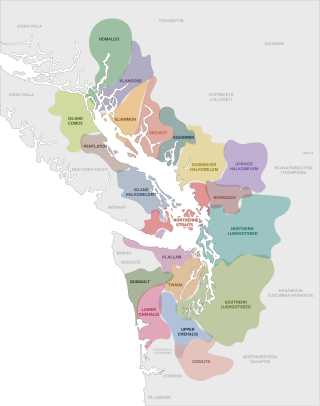
The Coast Salish languages, also known as the Central Salish languages, are a branch of the Salishan language family. These languages are spoken by First Nations or Native American peoples inhabiting the Pacific Northwest, in the territory that is now known as the southwest coast of British Columbia around the Strait of Georgia and Washington State around Puget Sound. The term "Coast Salish" also refers to the cultures in British Columbia and Washington who speak one of these languages or dialects.
Northgate is a neighborhood in north Seattle, Washington, named for and surrounding Northgate Mall, the first covered mall in the United States. Its north-south principal arterials are Roosevelt Way NE and Aurora Avenue N, and its east-west principal arterials are NE Northgate Way and 130th Street. Minor arterials are College Way-Meridian Avenue N, 1st, 5th, and 15th avenues NE. Interstate 5 runs through the district. Besides the eponymous mall, the most characteristic distinctions of the area are North Seattle College (NSC) and the south fork of the Thornton Creek watershed and Seattle Kraken Iceplex center.
Magnuson Park is a park in the Sand Point neighborhood of Seattle, Washington, United States. At 350 acres (140 ha) it is the second-largest park in Seattle, after Discovery Park in Magnolia. Magnuson Park is located at the site of the former Naval Station Puget Sound, on the Sand Point peninsula with Pontiac and Wolf bays that juts into Lake Washington in northeast Seattle.
The Industrial District is a neighborhood and the principal industrial area of Seattle, Washington. It is bounded on the west by the Duwamish River and Elliott Bay, beyond which lies Delridge of West Seattle; on the east by Interstate 5, beyond which lies Beacon Hill; on the north by S King and S Dearborn Streets, beyond which lie Pioneer Square and southwest International District of Downtown; and on the south by the main lines of the BNSF Railway and Union Pacific Railroad, or about S Lucille Street, beyond which is Georgetown. SoDo is the name of the northwest portion of the neighborhood, named for its being South of Downtown. SoDo is the location of T-Mobile Park, home of the Seattle Mariners, and Lumen Field, home of the Seattle Seahawks and Seattle Sounders FC. Lumen Field was also the site of the former Kingdome.
Lake City is a neighborhood and the northeast region of Seattle, centered along Lake City Way NE (SR-522), 7–8 miles (11–13 km) northeast of Downtown Seattle. A broader definition of the Lake City area includes all the land between 15th Avenue NE and Lake Washington, and between NE 95th and 98th streets to the Seattle city limits at NE 145th Street. Lake City encompasses much of the Thornton Creek watershed, the focus of a long restoration campaign by citizens and Seattle Public Utilities staff to enhance the residential environment of Lake City.
Delridge is a district in Seattle, Washington, United States that stretches along Delridge Way, an arterial that follows the eastern slope of the valley of Longfellow Creek, from near its source just within the southern city limits north to the West Seattle Bridge over the Duwamish River. It is generally associated with the neighborhing district of West Seattle, or even considered a sub-district of West Seattle.
Licton Springs or North College Park is a neighborhood in the informal Northgate district of North Seattle. It is bounded by Interstate 5 to the east, beyond which is Maple Leaf neighborhood and the Northgate Mall; Aurora Avenue N to the west, beyond which is Greenwood; N 85th Street to the south, beyond which is Green Lake, and N Northgate Way to the north, beyond which is Haller Lake.
Matthews Beach is a neighborhood in Seattle, Washington; it and Meadowbrook are the southern neighborhoods of the annexed township of Lake City (1954). Matthews Beach lies about 2 miles (3.2 km) northeast of the University of Washington, about 8 miles (13 km) northeast of Downtown.
Rainier Beach is a set of neighborhoods in Seattle, Washington that are mostly residential. Also called Atlantic City, Rainier Beach can include Dunlap, Pritchard Island, and Rainier View neighborhoods.
The Sammamish people are a Lushootseed-speaking Southern Coast Salish people. They are indigenous to the Sammamish River Valley in central King County, Washington. The Sammamish speak Lushootseed, a Coast Salish language which was historically spoken across most of Puget Sound, although its usage today is mostly reserved for cultural and ceremonial practices.
Meadowbrook is a neighborhood in the Lake City district of Seattle, Washington. Meadowbrook is centered on open fields adjacent to the Community Center, Meadowbrook swimming pool, and Nathan Hale High School. It is bounded on the south by NE 95th Street and the Wedgwood neighborhood, on the north by NE 120th Street and Cedar Park, on the west by Lake City Way NE and Victory Heights, and on the east by 35th Avenue NE and Matthews Beach.
Cheshiahud and his family on Lake Union, Seattle, Washington in the 1880s are, along with Princess Angeline, among the few late-19th century Dkhw'Duw'Absh about whom a little is known. In the University of Washington (UW) Library image archives, he is called Chudups John or Lake Union John. His family were among the few of the Duwamish people who did not move from Seattle to the Port Madison Reservation or other reservations. They lived on Portage Bay, part of Lake Union, when a photo was taken around 1885. According to the Duwamish Tribe, Lake John had a cabin and potato patch at the foot of Shelby Street. A commemorative plaque of unknown reliability is said to exist at the eastern foot of Shelby. This land was given to him by Seattle pioneer David Denny or the property was purchased—see below. Photographer Orion O. Denny recorded Old Tom and Madeline, ca. 1904, further noted in the UW Library archives as Madeline and Old John, also known as Indian John or Cheshishon, who had a house on Portage Bay in the 1900s, south of what is now the UW campus although native people had been prohibited from residence in Seattle since the mid-1860s.
The region now known as Seattle has been inhabited since the end of the last glacial period. Archaeological excavations at West Point in Discovery Park, Magnolia confirm that the Seattle area has been inhabited by humans for at least 4,000 years and probably much longer. West Point was called Oka-dz-elt-cu, Per-co-dus-chule, or Pka-dzEltcu. The village of tohl-AHL-too had been inhabited at least since the 6th century CE, as had hah-AH-poos—"where there are horse clams"—at the then-mouth of the Duwamish River in what is now the Industrial District. The Lushootseed (Skagit-Nisqually)-speaking Salish Dkhw'Duw'Absh and Xacuabš —ancestors of today's Duwamish Tribe—occupied at least 17 villages in the mid-1850s and lived in some 93 permanent longhouses (khwaac'ál'al) along the lower Duwamish River, Elliott Bay, Salmon Bay, Portage Bay, Lake Washington, Lake Sammamish, and the Duwamish River tributaries, the Black and Cedar Rivers.
The Duwamish tribe is a Native American tribe in western Washington, and the indigenous people of metropolitan Seattle. The Duwamish tribe today includes the People of the Inside (Dxw'Dəw?Abš), for Elliott Bay environs today; and the People of the Large Lake (Xacuabš), for those around Lake Washington of today.
The Coast Salish are a group of ethnically and linguistically related Indigenous peoples of the Pacific Northwest Coast, living in the Canadian province of British Columbia and the U.S. states of Washington and Oregon. They speak one of the Coast Salish languages. The Nuxalk nation are usually included in the group, although their language is more closely related to Interior Salish languages.
Matthews Beach Park is a 22-acre (0.9 km2) park in the Matthews Beach neighborhood of Seattle, Washington. It is a popular swimming beach in the summer, although it is also open during winter months.
The Shilshole people were a Lushootseed-speaking people whose territory was located around Salmon Bay near Seattle, Washington. Around the 19th century, they had just one village deep inside Salmon Bay. The last Shilshole were removed from their homes in 1914, and moved to the Port Madison Reservation to enable the construction of the Ballard Locks, although some assimilated into the nearby community of Ballard.
This page is based on this Wikipedia article Text is available under the CC BY-SA 4.0 license; additional terms may apply. Images, videos and audio are available under their respective licenses.