
The Ahom script or Tai Ahom Script is an abugida that is used to write the Ahom language, a dormant Tai language undergoing revival spoken by the Ahom people till the late 18th-century, who established the Ahom kingdom and ruled the eastern part of the Brahmaputra valley between the 13th and the 18th centuries. The old Ahom language today survives in the numerous manuscripts written in this script currently in institutional and private possession.
The Ahom or Tai-Ahom is an ethnic group from the Indian states of Assam and Arunachal Pradesh. The members of this group are admixed descendants of the Tai people who reached the Brahmaputra valley of Assam in 1228 and the local indigenous people who joined them over the course of history. Sukaphaa, the leader of the Tai group and his 9,000 followers established the Ahom kingdom, which controlled much of the Brahmaputra Valley in modern Assam until 1826.
The Ahom language or Tai-Ahom language is a dead language, that was formerly spoken by the Ahom people, but which is currently undergoing a revival. Ahom is an important language in Tai studies. It was relatively free of both Mon-Khmer and Indo-Aryan influences and has a written tradition dating back to the 13th century.

The Ahom dynasty (1228–1826) ruled the Ahom Kingdom in present-day Assam, India for nearly 598 years. The dynasty was established by Sukaphaa, a Shan prince of Mong Mao who came to Assam after crossing the Patkai mountains. The rule of this dynasty ended with the Burmese invasion of Assam and the subsequent annexation by the British East India Company following the Treaty of Yandabo in 1826.

Pangsau Pass or Pan Saung Pass, 3,727 feet (1,136 m) in altitude, lies on the crest of the Patkai Hills on the India–Myanmar border. The pass offers one of the easiest routes into Burma from the Assam plains. It is named after the closest Burmese village, Pangsau, that lies 2 km beyond the pass to the east. To the east of Pangsau Pass, India's undisputed easternmost point "Chaukan Pass" lies and to the east of Vijaynagar in the Changlang district.

Namrup is a small town situated close to the foothills of the Patkai Hills in the extreme southeastern part of Assam, India. The river Dihing or Disang flows through it. Namrup is situated in amidst wet-paddy fields, indigenous Assamese villages, orchards, large tea-gardens and densely forested hills. Administratively Namrup is located within Dibrugarh district and is today an important industrial town of Assam. Namrup is approximately 75 km from Dibrugarh by road towards the south-east and approximately 50 km from Tinsukia towards the south. It is also a small railway station in Dibrugarh-Guwahati broad-gauge railway line. The nearest airport is Dibrugarh located at a distance of approximately 70 km. Other urban areas close to Namrup are Naharkatiya - 18 km, Duliajan - 35 km, Sonari - 20 km, Moran - 55 km, etc. by roadways. Namrup is located around 500 km east of Guwahati, the largest city in the North East Region.
Sadiya is a town in Tinsukia district, Assam. It was the capital of the Chutia Kingdom and after the downfall of the kingdom it became the seat of the Sadiya-khowa-Gohain of the Ahom kingdom. Extensive remains of buildings and fortifications built during the rule of the Chutias near Sadiya still point to the importance of the region in the past. Historically Sadiya referred to the Chutiya kingdom which included at times the districts of Lakhimpur, Dhemaji and Tinsukia. It is claimed to be the center of development of the eastern Assamese dialects, the inscription here are written in a Tai script. Its stands on a grassy plain, almost surrounded by forested Himalayan mountains, on the right bank of Lohit River which is locally considered the main stream of the Brahmaputra River. The deepest point of the Brahmaputra River is located near this village. It is famous for a flower named satphul, which is much like Jasmine.
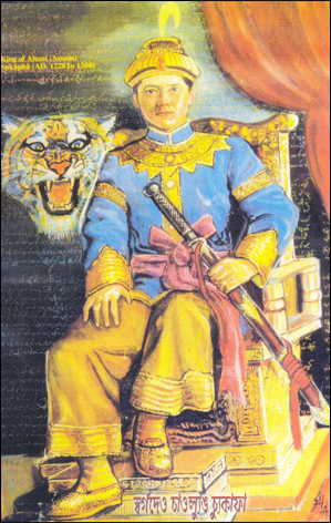
Sukaphaa, also Siu-Ka-Pha, the first Ahom king in medieval Assam, was the founder of the Ahom kingdom and the architect of Assam. A prince of the Su/Tsu (Tiger) clan of the Mao-Shan sub-tribe originally from present-day Mong Mao, Yunnan Province, China, the kingdom he established in 1228 existed for nearly six hundred years and in the process unified the various ethnic groups of the region that left a deep impact on the region. In reverence to his position in Assam's history the honorific Chaolung is generally associated with his name.

The Ahom kingdom was a late medieval kingdom in the Brahmaputra Valley that retained its independence for nearly 600 years despite encountering Mughal expansion in Northeast India. Established by Sukaphaa, a Tai prince from Mong Mao, it began as a mong in the upper reaches of the Brahmaputra based on wet rice agriculture. It expanded suddenly under Suhungmung in the 16th century and became multi-ethnic in character, casting a profound effect on the political and social life of the entire Brahmaputra valley. The kingdom became weaker with the rise of the Moamoria rebellion, and subsequently fell to repeated Burmese invasions of Assam. With the defeat of the Burmese after the First Anglo-Burmese War and the Treaty of Yandabo in 1826, control of the kingdom passed into East India Company hands.
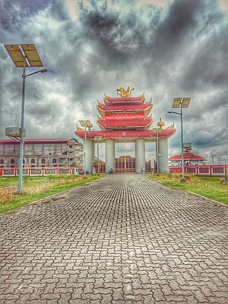
The Khamyang (Tai-Khamyangs or Shyam), is a subgroup of the Tai peoples of Southeast Asia. They are numerically a small indigenous group found in Tinsukia, Jorhat, Sivasagar and Golaghat districts of Assam, and adjacent parts of Arunachal Pradesh. Their population totals about 7,000, of which only a small minority speak the native Tai Khamyang language while the vast majority speak the Assamese language. The Khamyang are followers of Theravada Buddhism and are closely related to the Khamti. They maintain good relations with other Tai Buddhist tribes of Assam.

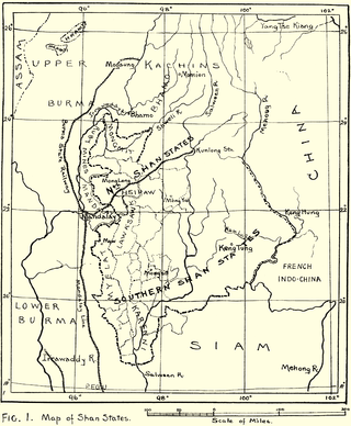
Muang Mao, also spelled MöngMao or the Mao Kingdom, was an ethnic Tai state that controlled several smaller Tai states or chieftainships along the frontier of what is now Myanmar, China, the states of Northeast India of Assam, and Arunachal Pradesh, principally set in the Dehong region of Yunnan with a capital near the modern-day border town of Ruili/Meng Mao. The name of the main river in this region is the Nam Mao, also known as the Shweli River.

The People of Assam inhabit a multi-ethnic, multi-linguistic and multi-religious society. They speak languages that belong to four main language groups: Tibeto-Burman, Indo-Aryan, Tai-Kadai, and Austroasiatic. The large number of ethnic and linguistic groups, the population composition, and the peopling process in the state has led to it being called an "India in miniature".
Khamyang is a critically endangered Tai language of India, spoken by the Khamyang people. Approximately fifty people speak the language; all reside in the village of Powaimukh, located seven miles downstream of Margherita in the Tinsukia district. It is closely related to the other Tai languages in the Assam region: Aiton, Khamti, Phake, and Turung.

The Chutia Kingdom was a late medieval state that developed around Sadiya in present Assam and adjoining areas in Arunachal Pradesh. It extended over almost the entire region of present districts of Lakhimpur, Dhemaji, Tinsukia, and some parts of Dibrugarh in Assam, as well as the plains and foothills of Arunachal Pradesh. The kingdom fell around the year 1524 to the Ahom Kingdom after a series of conflicts and the capital area ruled by the Chutia rulers became the administrative domain of the office of Sadia Khowa Gohain of the Ahom kingdom.

Dehing Patkai National Park is a national park in the Dibrugarh and Tinsukia districts of Assam covering an area of 231.65 km2 (89.44 sq mi) of rainforest. It was declared a wildlife sanctuary on 13 June 2004. On 13 December 2020, the Government of Assam upgraded it into a national park. On 9 June 2021, the Forest Department of Assam officially notified it as a national park. It is located in the Dehing Patkai Landscape which is a dipterocarp-dominated lowland rainforest. The rainforest stretches for more than 575 km2 (222 sq mi) in the districts of Dibrugarh, Tinsukia and Charaideo. The forest further spreads over in the Tirap and Changlang districts of Arunachal Pradesh. Dehing Patkai National Park harbours the largest stretch of lowland rainforests in India. Dehing Patkai Wildlife Sanctuary was declared as Dehing Patkai Elephant Reserve under Project Elephant. Dehing-Patkai as a potential wildlife sanctuary was identified in late 1980s during a primate survey as "Upper Dehing Wildlife Sanctuary". Subsequently during a study on white-winged wood duck in early 1990s, it was discovered as a globally important site for this duck and recommended to be upgraded to "Upper Dehing National Park".
The Turungpeople or Tai Turung, are a numerically small Buddhist community in the northeastern Indian state of Assam. They speak their own Turung language.
Sudangphaa (1397–1407) was the king of the Ahom kingdom. He was popularly known as Bamuni Konwar because of his upbringing in a Brahman's house. His reign marks the first stage in the growth of Hinduism in the Ahom dynasty. He initiated the Singarigharutha ceremony of the Ahom kings, a tradition which was followed by his successors.
The Kingdom of Pong or Pong Kingdom was an ethnically Tai state that controlled several smaller states along the frontier of what is now Myanmar and Assam.
Charaideo district is an administrative district in the state of Assam in India. It was formally declared a new district of the state on 15 August 2015 by then Chief Minister of Assam Tarun Gogoi. It has been carved out of Sivasagar district with Sonari as its administrative headquarter. It comes under Upper Assam division.
Dehing Patkai Landscape, located in the Upper Assam, stretches for over roughly 600 square kilometres and comprises three large blocks of forests and several forest fragments. The forest is classified as a lowland Tropical Wet Evergreen Forest (Dipterocarpus-Mesua). It falls under Indo-Burma Biodiversity Hotspot. Due to its biodiversity and significance for elephant habitat, parts of the landscape are recognised as Dehing Patkai Elephant Reserve and 111 km2 is protected as the Dehing Patkai Wildlife Sanctuary since 2004.