Hochon County

Last updated • 1 min readFrom Wikipedia, The Free Encyclopedia
Hochon County
허천군
Korean transcription(s)
  Hanja虛川郡
  McCune-ReischauerHŏch'ŏn kun
  Revised RomanizationHeocheon-gun
DPRK2006 Hamnam-Hochon.PNG
Map of South Hamgyong showing the location of Hochon
Coordinates: 40°45′57″N128°33′15″E / 40.76583°N 128.55417°E / 40.76583; 128.55417
Country North Korea
Province South Hamgyong Province
Administrative divisions 1 ŭp, 5 workers' districts, 17 ri
Area
  Total1,684 km2 (650 sq mi)
Population
 (2008 [1] )
  Total104,731
  Density62/km2 (160/sq mi)

Hŏch'ŏn County is a county in South Hamgyŏng province, North Korea. It was created after the division of Korea, from portions of Tanchon and P'ungsan (now Kimhyonggwon County).

Contents

Geography

Most of the county is steep and mountainous, particularly in the southeast. There are numerous high peaks. The Hamgyong Mountains and Geomdok Mountains (Korean : 검덕산맥) pass through the county with the highest peak at Mount Geomdok.

The chief stream is the Namdaecheon (Korean : 남대천). Approximately 90% of the county is forestland.

Administrative divisions

Hŏch'ŏn county is divided into 1 ŭp (town), 5 rodongjagu (workers' districts) and 17 ri (villages):

  • Hŏch'ŏn-ŭp
  • Mandŏng-rodongjagu
  • Ryongwŏl-lodongjagu
  • Sangnong-rodongjagu
  • Sangsal-lodongjagu
  • Sinhŭng-rodongjagu
  • Changp'yŏng-ri
  • Chungp'yŏng-ri
  • Ha'nong-ri
  • Hwachang-ri
  • Hwan'gong-ri
  • Hwangmyŏng-ri
  • Kŭmch'ang-ri
  • Sangnam-ri
  • Sat'ap-ri
  • Sinp'yŏng-ri
  • Suŭi-ri
  • Tonghŭng-ri
  • Ŭnhŭng-ri
  • Unsŭng-ri
  • Ŭr'am-ri
  • Wap'o-ri
  • Yangŭmp'yŏng-ri

Economy

Mining and electrical power are the chief local industries. There are deposits of copper, iron ore, lead, and zinc. Local crops include maize, soybeans, and potatoes, but cultivation is difficult due to the mountainous terrain.

Sangnong mine is located in this county, to the west of Sangnong-rodongjagu. [2]

Transportation

Hŏch'ŏn county is served by the Hŏch'ŏn and Mandŏk lines of the Korean State Railway, and by various roads.

Near Sangnong-rodongjagu, there is a trolleybus line to Sangnong mine served by one vehicle, though there were two vehicles in 2002. However, in more recent satellite imagery from 2020, the only trolleybus visible has disappeared. [3]

Military

The Sangnam-ri Ballistic Missile Base is located in the county. According to the Center for Strategic and International Studies, the existence of the base first came to public light in 1999, although construction began ca. 1994. Primary construction of barracks, underground facilities, bunkers, and other support structures was completed by the mid-2000s. Sangnam-ri is a battalion- or regiment-sized unit that encompasses approximately 3.85 sq. km of mountainous territory. It is operated by the Korean People's Army Strategic Force and is equipped with Hwasong-10 (Musudan) intermediate-range ballistic missiles. [4]

See also

Related Research Articles

<span class="mw-page-title-main">Onsong County</span> County in North Hamgyong Province, North Korea

Onsŏng County is a county (kun) in North Hamgyong Province, North Korea, located near the border with China. The administrative center is the town (ŭp) of Onsong. Onsong is the alleged site of the former Onsong concentration camp, now closed.

<span class="mw-page-title-main">Musan County</span> County in North Hamgyong Province, North Korea

Musan County is a county in central North Hamgyong province, North Korea. It borders the People's Republic of China to the north, across the Tumen River. It is divided into one ŭp, six labor districts, and fifteen ri. The county seat is the town of Musan, Musan ŭp. Luguo and Dehua are the closest Chinese cities across the river.

<span class="mw-page-title-main">Orang County</span> County in North Hamgyong Province, North Korea

Ŏrang County is a kun, or county, in North Hamgyŏng province, North Korea. It is situated on the coast of the Sea of Japan. Originally part of Kyŏngsŏng county, Ŏrang was created in 1952 following the division of Korea.

<span class="mw-page-title-main">Yonsa County</span> County in North Hamgyong Province, North Korea

Yŏnsa County is a kun, or county, in North Hamgyŏng province, North Korea. It was created following the division of Korea, being split off from Musan county in the 1952 reorganization of local government.

<span class="mw-page-title-main">Kyonghung County</span> County in North Hamgyong Province, North Korea

Kyŏnghŭng County is a kun, or county, in North Hamgyong province, North Korea. Formerly known as Ŭndŏk County, from 1977 to 2010.

<span class="mw-page-title-main">Kyongwon County</span> County in Kwanbuk, North Korea

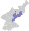
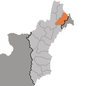
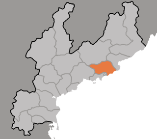
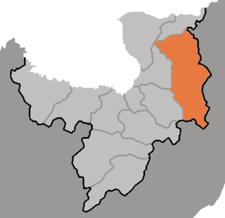
Kyŏngwŏn County is a kun, or county, in North Hamgyong province, North Korea, located at 42°48′41″N130°11′58″E, formerly known as Saebyŏl. It is bordered by the People's Republic of China to the north and east, Kyonghung to the southeast, Hoeryong to the southwest, and Onsong to the west.

<span class="mw-page-title-main">Puryong County</span> County in North Hamgyong Province, North Korea

Puryŏng County is a kun, or county, in North Hamgyŏng province, North Korea.

<span class="mw-page-title-main">Chongpyong County</span> County in South Hamgyong Province, North Korea

Chŏngp'yŏng County is a county in South Hamgyŏng province, North Korea. It borders South P'yŏngan province to the south, and the East Korea Bay to the east.

<span class="mw-page-title-main">Kumya County</span> County in South Hamgyong Province, North Korea

Kŭmya County is a county in South Hamgyŏng province, North Korea. It borders the Sea of Japan to the east.

<span class="mw-page-title-main">Changjin County</span> County in South Hamgyong Province, North Korea

Changjin County is a mountainous county in South Hamgyong Province, North Korea.

<span class="mw-page-title-main">Sinhung County</span> County in South Hamgyong Province, North Korea

Sinhŭng County is a mountainous county in South Hamgyŏng province, North Korea.

<span class="mw-page-title-main">Hongwon County</span> County in South Hamgyong Province, North Korea

Hongwŏn County is a county in South Hamgyŏng province, North Korea. It is flanked by the Sea of Japan to the south, and by the Hamgyŏng Mountains to the north.

<span class="mw-page-title-main">Riwon County</span> County in South Hamgyong Province, North Korea

Riwŏn or Iwon County is a county in South Hamgyŏng province, North Korea. It is located at the province's northeastern tip and borders the Sea of Japan to the southeast.

<span class="mw-page-title-main">Pukchong County</span> County in South Hamgyong, North Korea

Pukch'ŏng County is a county in eastern South Hamgyŏng province, North Korea.

<span class="mw-page-title-main">Kimhwa County</span> County in Kangwŏn Province, North Korea

Kimhwa County is a kun, or county, in Kangwŏn province, North Korea.

<span class="mw-page-title-main">Kimhyonggwon County</span> County in Ryanggang, North Korea

Kimhyŏnggwŏn County is a kun, or county, in southeastern Ryanggang province, North Korea. It borders South Hamgyŏng to the south. Previously known as Pungsan, it was renamed by Kim Il Sung in 1990. He named it after his uncle, Kim Hyŏng-gwŏn. It is known for its striking scenery and for the Pungsan Dog, a large breed of hunting dog.

<span class="mw-page-title-main">Paegam County</span> County in Ryanggang, North Korea

Paegam County is a kun, or county, in Ryanggang province, North Korea.

<span class="mw-page-title-main">Pungso County</span> County in Ryanggang, North Korea

P'ungsŏ County is a kun, or county, in Ryanggang province, North Korea. It was formed after the division of Korea from portions of Kimhyŏnggwŏn and Kapsan counties.

<span class="mw-page-title-main">Rangrim County</span> County in Chagang Province, North Korea

Rangrim County is a kun, or county, on the eastern flank of Chagang province, North Korea. It was created in 1952 from portions of Changgang and Changjin, as part of a general reorganization of local government. Originally part of South Hamgyong, it was transferred to Chagang province in 1954. It borders Hwapyong and Ryanggang's Kimjongsuk and Kimhyongjik counties to the north, South Hamgyong's Pujon county to the east and Changjin to the south, as well as the counties of Changgang, Songgan, and Ryongnim to the west.

<span class="mw-page-title-main">Taegwan County</span> County in North Pyŏngan, North Korea

Taegwan County is a kun, or county, in northeastern North P'yŏngan province, North Korea. It lies in the province's interior, and is bounded by Tongch'ang on the east, Kusŏng and T'aech'ŏn to the south, Ch'ŏnma to the west, and Ch'angsŏng and Sakchu to the north. It was created in 1952 from portions of Sakchu county.

References

  1. North Korea: Administrative Division
  2. "북한지역정보넷". www.cybernk.net. Retrieved 2021-02-05.
  3. "Sangnong". transphoto.org. Retrieved 2021-02-07.
  4. Joseph Bermudez; Victor Cha; Lisa Collins (15 February 2019). "Undeclared North Korea: The Sangnam-ni Missile Operating Base". Beyond Parallel. Retrieved 5 September 2022.