Onsŏng County is a county (kun) in North Hamgyong Province, North Korea, located near the border with China. The administrative center is the town (ŭp) of Onsong. Onsong is the alleged site of the former Onsong concentration camp, now closed.

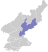
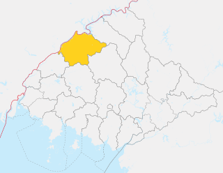
Ŭiju County is a kun, or county, in North Pyongan Province, North Korea. The county has an area of 420 km², and a population of 110,018.

Kimhyŏngjik County is a kun of Ryanggang Province, North Korea. Formerly known as Huch'ang County, it was renamed in 1988 in honour of Kim Hyŏng-jik, the leader of the anti-Japanese liberation movement of Korea.
Kŭmya County is a county in South Hamgyŏng province, North Korea. It borders the Sea of Japan to the east.

Yodŏk County is a county in South Hamgyŏng province, North Korea. Originally part of Yŏnghŭng county, it became a separate entity as part of the 1952 reorganization of local government.

Changjin County is a mountainous county in South Hamgyong Province, North Korea.

Anbyŏn is a kun, or county, in Kangwŏn province, North Korea. Originally included in South Hamgyŏng province, it was transferred to Kangwŏn province in a September 1946 reshuffling of local government.

Ch'ŏrwŏn County is a kun, or county, in Kangwŏn province, North Korea. Portions of it were once a single county together with the county of the same name in South Korea; other portions were added from neighbouring counties in the 1952 reorganization of local governments. After the initial division of Korea, the entire county lay to the Northern side of the dividing line, but in the course of the Korean War part of the county was taken by the South.

Kimhwa County is a kun, or county, in Kangwŏn province, North Korea.
P'an'gyo County is a kun, or county, in Kangwŏn province, North Korea. In December 1952, during the Korean War, P'an'gyo was formed as a separate county from five myŏn of Ichŏn-gun and Yujin-myŏn of P'yŏnggang-gun. Myŏn were administrative units below county (kun) level and are no longer used in North Korea.

P'yŏnggang County is a kun, or county, in Kangwŏn province, North Korea. It borders Sep'o to the north, Ch'ŏrwŏn to the south, Ich'ŏn to the west, and Kimhwa to the east.

Kim Jong Suk County is a kun, or county, in Ryanggang province, North Korea, along the Yalu River.

Taehongdan County is a kun, or county, in Ryanggang province, North Korea. It was originally part of Musan County.

Ch'osan County is a kun, or county, in Chagang province, North Korea. It borders the People's Republic of China to the north.

Sŏnch'ŏn County is a kun, or county, on the coast of the Yellow Sea in west-central North P'yŏngan province, North Korea. To the north it borders Ch'ŏnma, to the east Kusŏng and Kwaksan, and to the west Tongrim; to the south, it borders nothing but the sea. Sŏnch'ŏn was reorganized in 1952, with two myŏn, or townships, being split off to form the new county of Tongrim.

Pakch'ŏn County is a kun, or county, in southern North P'yŏngan province, North Korea. It is bordered to the north by T'aech'ŏn, to the east and southeast by Nyŏngbyŏn, and to the west by Unjŏn counties. To the south, it looks across the Ch'ŏngch'ŏn River at Anju city and Mundŏk county in South P'yŏngan province. In 1952, 4 myŏn of Pakch'ŏn were split off to join Unjŏn county; since then, the county's administrative divisions have been revised in 1954, 1956, 1958, 1978, 1980, and 1982.
Pyŏktong County is a kun, or county, in northern North P'yŏngan province, North Korea. It lies in the valley of the Yalu River, and borders China to the north. Within North Korea, it is bounded by Tongch'ang to the south, Ch'angsŏng to the west, and Usi county in Chagang province to the east. It was separated from Usi in 1952, as part of a nationwide reorganization of local government.
Sakju County is a kun, or county, in northern part of North P'yŏngan province, in North Korea. It lies along the Yalu River bordering the People's Republic of China to the north. Within North Korea, it borders Ch'angsŏng to the east, Ch'ŏnma and Taegwan to the south, and Ŭiju to the west.

T'aechŏn County or Thaechŏn County is a kun, or county, in central North P'yŏngan province, North Korea. It borders Taegwan and Tongch'ang to the north, Unsan and Nyŏngbyŏn to the east, Pakch'ŏn and Unjŏn to the south, and Kusŏng to the west.
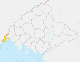
Sindo County is a kun (county) in the North P'yŏngan province of North Korea. Most of the county consists of Pidansŏm, an island in the estuary of the Yalu River. Sindo was established as a separate county in 1991; previously, it had been part of Ryongch'ŏn, although it had enjoyed a brief existence as a separate county in 1967.