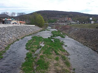
Chest Creek is a tributary of the West Branch Susquehanna River in Cambria County and Clearfield County, in Pennsylvania, in the United States. It is approximately 40.4 miles (65.0 km) long and flows through Allegheny Township, East Carroll Township, Clearfield Township, Patton, Chest Township, and Elder Township in Cambria County and Westover borough, Chest Township, Newburg, Bell Township, and Mahaffey in Clearfield County. Although it is considered by the Pennsylvania Department of Environmental Protection to be impaired by situation, it is a coldwater fishery or a high-quality coldwater fishery throughout its length. The watershed of the creek has an area of 129.22 square miles (334.7 km2).
Mahoning Creek is a tributary of the Susquehanna River in Columbia County and Montour County, in Pennsylvania, in the United States. It is approximately 10.6 miles (17.1 km) long and flows through Madison Township in Columbia County and West Hemlock Township, Derry Township, Valley Township, Mahoning Township, and Danville in Montour County. The watershed of the creek has an area of 39.6 square miles (103 km2). Its tributaries include Kase Run, Mauses Creek, and Sechler Run. Mahoning Creek is designated as a Trout-Stocking Fishery and a Migratory Fishery for part of its length and as a Warmwater Fishery and a Migratory Fishery for the remainder.

Limestone Run is a tributary of the West Branch Susquehanna River, in Montour County and Northumberland County, in Pennsylvania, in the United States. It is 8.8 miles (14.2 km) long and flows through Limestone Township in Montour County and Turbot Township and Milton in Northumberland County. The watershed has an area of 11.6 square miles (30 km2). Slightly under 2,500,000 pounds (1,100,000 kg) of sediment flow through the stream annually. The stream's watershed is in the ridge and valley physiographic province.

Turtle Creek is a tributary of the West Branch Susquehanna River in Union County, Pennsylvania, in the United States. It is 8.4 miles (13.5 km) long and flows through Limestone Township, Buffalo Township, and East Buffalo Township. The watershed of the creek has an area of 12.7 square miles (33 km2). The creek is designated as an impaired waterbody, with the cause of the impairment being siltation and the source being agriculture. It has a daily sediment load of 6,372 pounds (2,890 kg). The main surficial rock types in the creek's watershed include shale, carbonate, and sandstone. The creek is in the ridge and valley physiographic province.
North Branch Mahantango Creek is a tributary of Mahantango Creek in Snyder County, Pennsylvania, in the United States. It is 13.3 miles (21.4 km) long and flows through West Perry Township, Perry Township, and Chapman Township. The creek's mouth is at 438 feet (134 m) above sea level.

Mud Run is a tributary of Green Creek in Columbia County, Pennsylvania, in the United States. It is 5.7 miles (9.2 km) long and flows through Greenwood Township. The stream's watershed has an area of 13.3 square miles and is located in Greenwood Township, Orange Township, and Mount Pleasant Township. The stream is in the ridge and valley physiographic province. Its annual load of sediment is 4,394,600 pounds (1,993,400 kg). The Kramer Covered Bridge crosses the stream.

Spruce Run is a tributary of Buffalo Creek in Union County, Pennsylvania, in the United States. It is approximately 14 miles (23 km) long and flows through Hartley Township, Lewis Township, West Buffalo Township, White Deer Township, Buffalo Township, and Kelly Township. The watershed of the stream has an area of 27.2 square miles (70 km2). The stream has two named tributaries: Black Run and Muddy Run. It is not designated as an impaired waterbody, but it is affected by sediment and nutrients.

Beaver Run is a tributary of Buffalo Creek in Union County, Pennsylvania, in the United States. It is approximately 3.7 miles (6.0 km) long and flows through Buffalo Township. The watershed of the stream has an area of 4.78 square miles (12.4 km2). It is designated as an impaired stream due to siltation from agricultural activity. A significant majority of the stream's watershed is on agricultural land and only a tiny minority is on forested land.
Rapid Run is a tributary of Buffalo Creek in Centre County and Union County in Pennsylvania, in the United States. It is approximately 14.4 miles (23.2 km) long and flows through Miles Township in Centre County and Hartley Township, Lewis Township, West Buffalo Township, and Buffalo Township in Union County. The watershed of the stream has an area of 18.7 square miles (48 km2). Some streams in the watershed are impacted by nutrients, sediment, E. coli, and thermal radiation and one unnamed tributary is designated as an impaired waterbody. Rapid Run is a freestone mountain stream in the ridge and valley physiographic province. It flows through a lake known as Halfway Lake and also passes through the Rapid Run Gap.
Coal Run is a tributary of North Branch Buffalo Creek in Union County, Pennsylvania, in the United States. It is approximately 3.6 miles (5.8 km) long and flows through Lewis Township and West Buffalo Township. The watershed of the stream has an area of 5.33 square miles (13.8 km2). A few streams in its watershed are designated as impaired due to nutrients and siltation. The watershed mostly consists of agricultural and forested land. Wild trout occur within the stream.

Boile Run is a tributary of the Susquehanna River in Northumberland County, Pennsylvania, in the United States. It is approximately 4.7 miles (7.6 km) long and flows through Lower Augusta Township. The watershed of the stream has an area of 5.97 square miles (15.5 km2). The stream is not designated as an impaired waterbody and is a relatively small stream. There was a mill on Boile Run in the second half of the 1800s and several bridges have been built over the stream. Its watershed is designated as a Warmwater Fishery and a Migratory Fishery.

Mouse Creek is a tributary of Schwaben Creek in Northumberland County, Pennsylvania, in the United States. It is approximately 5.6 miles (9.0 km) long and flows through Jordan Township, Washington Township, and Jackson Township. The watershed of the creek has an area of 7.19 square miles (18.6 km2). The creek and its tributaries are not designated as impaired waterbodies. Its watershed is at least partially in the ridge and valley physiographic province. The main land use in the upper reaches of the creek's drainage basin are forested land and agricultural land, but other land uses exist as well. A number of bridges have been constructed across the creek.

Fidlers Run is a tributary of the Susquehanna River in Northumberland County, Pennsylvania, in the United States. It is approximately 3.1 miles (5.0 km) long and flows through Jackson Township and Lower Mahanoy Township. The watershed of the stream has an area of 6.88 square miles (17.8 km2). The stream is not designated as an impaired waterbody, although a reaches of a few of its unnamed tributaries are. It is a small stream, with a width of 3 to 5 feet. Large areas of agricultural land occur along a substantial portion of its length.
Silver Creek is a tributary of the Susquehanna River in Snyder County, Pennsylvania, in the United States. It is approximately 6.1 miles (9.8 km) long and flows through Washington Township and Union Township. The watershed of the creek has an area of 5.92 square miles (15.3 km2). The creek has no named tributaries, but it does have several unnamed tributaries. Many of these, as well as Silver Creek itself, are impaired by sedimentation/siltation due to grazing-related agriculture. The watershed is partly or fully in the Ridge and Valley physiographic province.
Chapman Creek is a tributary of the Susquehanna River in Snyder County, Pennsylvania, in the United States. It is approximately 4.2 miles (6.8 km) long and flows through Union Township and Chapman Township. The watershed of the creek has an area of 2.81 square miles (7.3 km2). The creek has no named tributaries and is not designated as an impaired waterbody. Its drainage basin is designated as a Warmwater Fishery and a Migratory Fishery.

Dalmatia Creek is a tributary of the Susquehanna River in Northumberland County, Pennsylvania, in the United States. It is approximately 2.8 miles (4.5 km) long and flows through Lower Mahanoy Township. The watershed of the creek has an area of 2.80 square miles (7.3 km2). The creek has no named tributaries, but several unnamed ones. Both it and its tributaries are designated as impaired waterbodies due to sedimentation/siltation from crop-related agriculture and vegetation removal. Streambank erosion also occurs in the watershed. The creek is in the Ridge and Valley physiographic province.
Aline Creek is a tributary of North Branch Mahantango Creek in Snyder County, Pennsylvania, in the United States. It is approximately 2.3 miles (3.7 km) long and flows through Perry Township. The watershed of the creek has an area of 1.61 square miles (4.2 km2). The creek has no named tributaries, but does have one unnamed tributary. A reach of Aline Creek is designated as an impaired waterbody due to siltation/sedimentation from agriculture and removal of vegetation. The creek's drainage basin is designated as a Coldwater Fishery and a Migratory Fishery.
Leiningers Run is a tributary of West Branch Mahantango Creek in Juniata County, Pennsylvania, in the United States. It is approximately 4.9 miles (7.9 km) long and flows through Greenwood Township and Susquehanna Township. The watershed of the stream has an area of 6.96 square miles (18.0 km2). A reach of the stream is designated as an impaired waterbody due to miscellaneous habitat alteration from habitat modifications not including hydromodification. The stream's drainage basin is designated as a Coldwater Fishery and a Migratory Fishery.
Boyers Run is a tributary of the Susquehanna River in Juniata County and Perry County, in Pennsylvania, in the United States. It is approximately 2.8 miles (4.5 km) long and flows through Susquehanna Township in Juniata County and Liverpool Township in Perry County. The watershed of the stream has an area of 1.63 square miles (4.2 km2). The stream has one unnamed tributary and is not designated as an impaired waterbody. The drainage basin of Boyers Run is designated as a Warmwater Fishery and a Migratory Fishery.
Millard Creek is a tributary of Tunkhannock Creek in Susquehanna County, Pennsylvania. It is approximately 6.2 miles (10.0 km) long and flows through Harford Township and Lenox Township. The watershed of the creek has an area of 5.66 square miles (14.7 km2). The creek is not designated as an impaired waterbody. The surficial geology in its vicinity includes Wisconsinan Till, alluvium, wetlands, lakes, bedrock, and alluvial fan. The dominant land uses in the creek's watershed include forested land and agricultural land. A number of bridges have been constructed over the creek. Its drainage basin is designated as a Coldwater Fishery and a Migratory Fishery.
