
Pilatus, also often referred to as Mount Pilatus, is a mountain massif overlooking Lucerne in Central Switzerland. It is composed of several peaks, of which the highest is named Tomlishorn.

Appenzell is a village, though considered as a town by the FSO, and the capital of the canton of Appenzell Innerrhoden in Switzerland. Appenzell has no municipal government of its own; rather, the different parts of Appenzell belong to and are governed by the districts Appenzell, Schwende and Rüte. Because of that, for firefighting, energy and water, the village Appenzell has a special-purpose municipality, the Feuerschaugemeinde.

The Schilthorn is a summit in Europe, in the Bernese Alps of Switzerland. It overlooks the valley of Lauterbrunnen in the Bernese Oberland, and is the highest mountain in the range lying north of the Sefinenfurgge Pass. The Schilthorn lies above the village of Mürren, from where a cable car leads to its summit.

The Uetliberg is a mountain in the Swiss plateau, part of the Albis chain, rising to 870 m (2,850 ft). The mountain offers a panoramic view of the entire city of Zürich and the Lake of Zurich, and lies on the boundary between the city of Zürich and the municipalities of Stallikon and Uitikon. The summit, known as Uto Kulm, is in Stallikon.
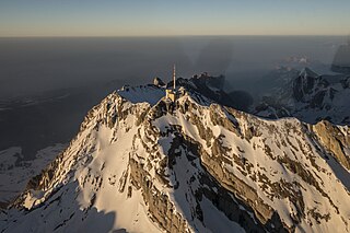
At 2,501.9 metres (8,208 ft) above sea level, Säntis is the highest mountain in the Alpstein massif of northeastern Switzerland. It is also the culminating point of the whole Appenzell Alps, between Lake Walen and Lake Constance. Shared by three cantons, the mountain is a highly visible landmark thanks to its exposed northerly position within the Alpstein massif. As a consequence, houses called Säntisblick can be found in regions as far away as the Black Forest in Germany. Säntis is among the most prominent summits in the Alps and the most prominent summit in Europe with an observation deck on the top. The panorama from the summit is spectacular. Six countries can be seen if the weather allows: Switzerland, Germany, Austria, Liechtenstein, France, and Italy.

Monte Generoso is a mountain of the Lugano Prealps, located on the border between Switzerland and Italy and between Lake Lugano and Lake Como. The western and southern flanks of the mountain lie in the Swiss canton of Ticino, whilst the north-eastern flanks are in the Italian region of Lombardy.
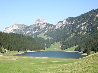
Sämtisersee is a lake in the Alpstein range of the canton of Appenzell Innerrhoden, Switzerland. At an elevation of 1209 m, the surface area is 13 ha. It is located below Hoher Kasten not far from Fälensee.

Wildkirchli are three interlinked caves situated in the Alpstein massif in the Appenzell Innerrhoden canton of Switzerland, north-east of Mount Säntis Switzerland. The caves are located at a height of 1,477–1,500 m (4,846–4,921 ft). They are notable for the traces of Paleolithic Neanderthal habitation, dating to c. 40,000 BP, and cave bear bones dating to 90,000–40,000 BP. A museum at the site houses a full bear skeleton that was found in one of the caves.
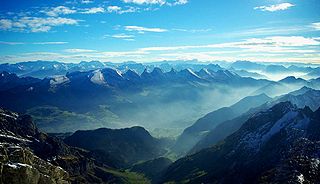
The Appenzell Alps are a mountain range in Switzerland on the northern edge of the Alps. They extend into the cantons of Appenzell Ausserrhoden, Appenzell Innerrhoden and St. Gallen and are bordered by the Glarus Alps to the west and the Rätikon to the south-east.

The Kehlstein is a 1,881 m (6,171 ft) subpeak of the Göll massif, a 2,522-metre-high (8,274 ft) mountain in the Berchtesgaden Alps. The rocky promontory is located west of the Hoher Göll main summit, high above the Obersalzberg mountain retreat near Berchtesgaden. It is chiefly known for the Kehlsteinhaus mountain inn built in 1937–1938, which is a major tourist destination.

Hohsaas is a cable car station and a ski area in the Pennine Alps above Saas Grund in Valais.

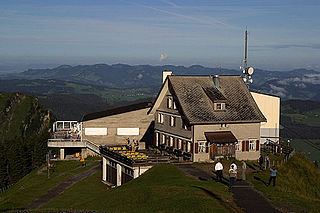
The Ebenalp is the northernmost summit of the Appenzell Alps. The mountain is a popular hiking destination and has been accessible by cable car from Wasserauen since 1955. Ebenalp attracts up to 200,000 visitors each year.
Planplatten is a mountain situated above Meiringen in the Bernese Oberland in Switzerland. In 1999 a panoramic restaurant has been built on the summit which is accessible by gondola lift.

The Brend is a mountain, 1,149.3 m above sea level (NHN), in the Central Black Forest in Germany. It is the highest point in the borough of Furtwangen of which it is the Hausberg.

The Torino Hut is a high mountain refuge in the Alps in northwestern Italy. Located near the border with France, it is about 15 km (10 mi) southwest of Mont Dolent, the tripoint with Switzerland. The refuge is in the Mont Blanc massif above the town of Courmayeur in the Aosta Valley, Italy. It can be most easily accessed from the Italian side by the Skyway Monte Bianco cable car from La Palud in Courmayeur, with a change at the Pavilion du Mont Fréty. It can also be reached from Chamonix via the Aiguille du Midi, either by cable car which crosses the massif, or by a long crossing of the Glacier du Gèant. The refuge lies nearly directly above the 11.6 km (7.2 mi) Mont Blanc Tunnel, which passes deep underground, and connects Courmayer to Chamonix.

The Bregenz Forest Mountains, also the Bregenzerwald Mountains, are a range of the Northern Limestone Alps and Eastern Alps, named after the town of Bregenz. The Bregenz Forest Mountains are located entirely in the Austrian state of Vorarlberg.
The Kronberg is a mountain of the Appenzell Alps, located west of Appenzell in the Swiss canton of Appenzell Innerrhoden. Its 1,663-metre-high (5,456 ft) summit can be accessed by cable car.
Kasten is a surname. Notable people with the surname include:

The Scheidegg is a mountain summit of the Rigi massif, overlooking Goldau in the canton of Schwyz on its north mountainside, and Gersau and the Gersauerbecken on its south side. The cable car station 160 metres east of it is called Rigi Scheidegg.

The Kamor is a mountain in the Appenzell Alps and has an elevation of 1,751 m above the sea. It is part of a mountain belt which forms the western boundary of the Rhine Valley and is located on the border of the Swiss cantons Appenzell Innerrhoden and Canton of St. Gallen.

