Holcaspis brevicula | |
---|---|
![]() | |
Scientific classification ![]() | |
Domain: | Eukaryota |
Kingdom: | Animalia |
Phylum: | Arthropoda |
Class: | Insecta |
Order: | Coleoptera |
Family: | Carabidae |
Genus: | Holcaspis |
Species: | H. brevicula |
Binomial name | |
Holcaspis brevicula Butcher, 1984 | |
Holcaspis brevicula, the Eyrewell ground beetle, [2] is a species of carabid beetle native to New Zealand, one of a number of small black flightless beetles in the genus Holcaspis that inhabit the dry eastern lowlands of the South Island. H. brevicula is very rare—only ten specimens have ever been collected—and critically endangered: the species was found only in Eyrewell Forest, a single plantation of exotic pine trees currently being converted into dairy farms.
Holcaspis brevicula was named and described in 1984 by Michael Butcher in a revision of the genus Holcaspis. [3] At that point it was known from only two male specimens, both collected in Eyrewell Forest on the Canterbury Plains in 1961. H. brevicula can be distinguished from its slightly larger close relative H. algida by the patterns of punctures and setae on its pronotum and elytra, and by the male's shorter aedeagus. [3] It is a small (10–11 mm long) shiny black ground beetle, and is flightless, predatory, and probably nocturnal. As adults have been collected during winter months, H. brevicula probably lives for over two years – relatively long for a beetle. [4]
The Eyrewell Forest area has dry, stony, free-draining soils, and its original vegetation area was probably kānuka ( Kunzea serotina ) shrubland and forest up to 10 m high, with some tōtara ( Podocarpus totara ). [5] [6] This habitat was widely burnt off by Polynesian and European settlers, and now exists on the Canterbury Plains only as small fragments, less than 20 ha. There are several such fragments in the Eyrewell area, the largest being the 16 ha Spencer-Bower Reserve. [6] [7] All are on private land, some protected by a QEII covenant, except for the Eyrewell Scientific Reserve (2.4 ha), which is administered by the Department of Conservation. [5]
The poor soil at Eyrewell was considered unsuitable for agriculture and used mainly for sheep farming. [8] Between 1928 and 1932, the 30 foot (9.1 m) tall mānuka ( Leptospermum scoparium ) forest at Eyrewell was cleared and the 6764 ha Eyrewell Forest plantation of introduced Monterey pine ( Pinus radiata ) was established. [4] Most of the area has been in plantation forestry ever since, with blocks of trees being felled in rotation approximately every 27 years. Some of the older blocks had an understory of kānuka up to 4 m high and most included native shrubs, herbs, and mosses, despite regular tree felling and replanting. [5]
Holcaspis brevicula was present in kānuka forest at the time it was knocked down and interplanted with pine trees, and has persisted in the regularly-felled plantation forest. At the same time it has disappeared from the remaining fragments of nearby kānuka forest, which appear to be too small, increasingly degraded, and browsed by sheep to support populations of the beetle. [8] [9] Intensive searching and pitfall trapping in remnant kānuka forest, pine plantation, and adjacent pasture, comprising 57,494 trap days over 2000–2005, captured five more specimens of H. brevicula. All were found in the pine forest. [4] Three more specimens, collected between 1956 and 1967, were located in the Forest Research Insect Collection. All the ten known specimens of this beetle came from the Eyrewell Forest, which thus contains the only known population of this species. [4]
Because of its rarity and single locality, H. brevicula is classified as "nationally critical and under acute threat of extinction". [1] [10] It was chosen as one of the 150 priority species in the Department of Conservation's 2017 Threatened Species Strategy. [11] The beetle has no legal protection under the Wildlife Act, and in New Zealand plantation forests on private land can be felled, even if they are the only habitat of a threatened species. [2]
Land-use change in the Canterbury Plains in the 21st century has been towards irrigation and dairy farming, more profitable than traditional dryland farming and forestry. Eyrewell Forest was Crown Land, administered by the New Zealand Forest Service; it was purchased from Ngāi Tahu in 1848 as part of the £2000 Kemp Purchase of 8 million ha. [12] In 2000, the Eyrewell Forest was returned to Ngāi Tūāhuriri, a subtribe of Ngāi Tahu, as part of the 1998 Ngai Tahu settlement. [13] Ngāi Tahu Farming proposed converting 1200 ha of the land, now known as Te Whenua Hou, into three trial dairy farms, in the face of some opposition from within the iwi. [14] Six farms were later established as forestry licenses expired, then a seventh. [12] In 2016 it was announced the Eyrewell Forest would be completely felled and converted into 8,500 ha of pivot-irrigated pasture to support 14,000 dairy cows in 13 farms and 7 dairy support farms, with almost all the forest to be cleared by 2017/2018. [12] [15] [16] As of January 2019, all but 120 ha of the Eyrewell Forest had been cleared, [17] as can be seen in Sentinel satellite imagery. [18] The conversion involved "felling all the trees, ripping out the root stock and then pretty much mulching the coarser woody material which is left behind into small chips… not only shredding any plant matter, but any invertebrates that are larger than a pinhead." [17]
Correspondence obtained under the Official Information Act revealed that the Department of Conservation had been unable to reach an agreement with Ngāi Tahu Farming over preserving enough beetle habitat to save the species. [17] Forest and Bird criticised the Whenua Hou development, claiming it would lead to the extinction of H. brevicula. [2] Ngāi Tahu responded that they would be planting 150 ha of native shrubland to replace the 6700 ha of pine habitat, and a further 150 ha around the edges of farms and buildings. [6] [19] The beetle does not currently inhabit the remaining native forest in the area, so it is unclear whether it would colonise and inhabit these new plantings. [4] The revegetation project appears to have been largely unsuccessful, with forest trees being planted in dry open pastures, exposed to excess nutrient runoff from cow pasture. [6]
Lincoln University have been surveying the remaining forest since 2013 without finding any Eyrewell beetles; the surveys are set to continue until 2020. [17] Scientists criticised the decision to convert the forest to dairy farms as "driven by an economic assessment of profitability, with little consideration of biodiversity values." [8] If Ngāi Tahu Farming did not restore kānuka forest or set aside areas of plantation forestry, H. brevicula would soon be extinct. [8] The lead scientist on the study said in November 2018 he was thinking of writing the beetle's obituary. [2]
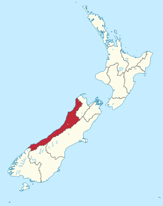
The West Coast is a region of New Zealand on the west coast of the South Island. It is administered by the West Coast Regional Council, and is known co-officially as Te Tai Poutini. It comprises the territorial authorities of Buller District, Grey District and Westland District. The principal towns are Westport, Greymouth and Hokitika. The region, one of the more remote areas of the country, is also the most sparsely populated. With a population of just 32,900 people, the West Coast is the least populous region in New Zealand. The population in the region grew by 0.4% over the year to July 2023.
Pinus radiata, the Monterey pine, insignis pine or radiata pine, is a species of pine native to the Central Coast of California and Mexico. It is an evergreen conifer in the family Pinaceae.
The New Zealand falcon is New Zealand's only falcon. Other common names for the bird are bush hawk and sparrow hawk. It is frequently mistaken for the larger and more common swamp harrier. It is the country's most threatened bird of prey, with only around 3000–5000 breeding pairs remaining.
Ngāi Tahu, or Kāi Tahu, is the principal Māori iwi (tribe) of the South Island. Its takiwā is the largest in New Zealand, and extends from the White Bluffs / Te Parinui o Whiti, Mount Mahanga and Kahurangi Point in the north to Stewart Island / Rakiura in the south. The takiwā comprises 18 rūnanga corresponding to traditional settlements. According to the 2018 census an estimated 74,082 people affiliated with the Kāi Tahu iwi.
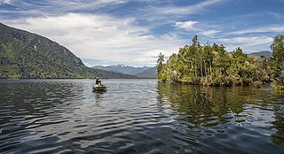
Lake Brunner is the largest lake in the West Coast Region of New Zealand, located 31 km (19 mi) southeast of Greymouth. The main settlement, Moana, is on its northern shore. It is an important settlement and waystation for local Māori. The first Europeans in the area were loggers, and sawmills were an important early industry. Being several kilometres inland from the coast road, it is less frequently visited by tourists than many of the West Coast's scenic highlights, but it is becoming increasingly popular, in part due to its reputation for fishing.
Central Plains Water, or, more fully, the Central Plains Water Enhancement Scheme, is a large-scale proposal for water diversion, damming, reticulation and irrigation for the Central Plains of Canterbury, New Zealand. Construction started on the scheme in 2014.
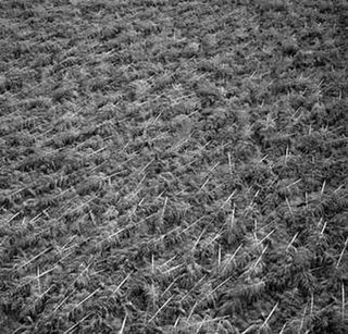
Wilding conifers, also known as wilding pines, are invasive trees in the high country of New Zealand. Millions of dollars are spent on controlling their spread.
In New Zealand, agriculture is the largest sector of the tradable economy. The country exported NZ$46.4 billion worth of agricultural products in the 12 months to June 2019, 79.6% of the country's total exported goods. The agriculture, forestry and fisheries sector directly contributed $12.653 billion of the national GDP in the 12 months to September 2020, and employed 143,000 people, 5.9% of New Zealand's workforce, as of the 2018 census.
Pseudocoremia suavis, the common forest looper, is a species of moth in the family Geometridae. It is regarded as being endemic to New Zealand. In 2007, however, the moth was found in west Cornwall, Great Britain, the first time it has been found outside of New Zealand.
Forestry in New Zealand has a history starting with European settlement in the 19th century and is now an industry worth seven percent of annual revenue. Much of the original native forest cover was burnt off and logged, however forests have been extensively planted, predominantly with fast-growing cultivars of the Monterey Pine. Wood chips, whole logs, lumber and paper products are exported from New Zealand.
The Canterbury–Otago tussock grasslands is an ecoregion of the South Island, New Zealand, part of the wider tussock grasslands of New Zealand.
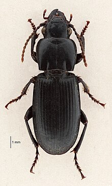
Holcaspis is a genus of beetles in the family Carabidae, endemic to New Zealand.
Eyrewell Forest is a small rural area in the Waimakariri District, New Zealand.
Platypus apicalis, known by its common name the New Zealand pinhole boring beetle, is a wood-boring beetle endemic to New Zealand and found throughout the North and South Island in a range of environments.
Ngāi Tahu Holdings Corporation Limited is owned by the Ngāi Tahu iwi of the South Island of the New Zealand. Its main interests are in tourism, fisheries, property and forestry and it is among the wealthiest iwi in New Zealand. Ngāi Tahu annually contributes more than $200 million to the South Island economy.
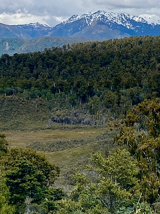
Pakihi or pākihi is a vegetation association unique to the West Coast of the South Island of New Zealand, characterised by flat boggy land with infertile, waterlogged soil on which only rushes, ferns, moss, and mānuka grow.
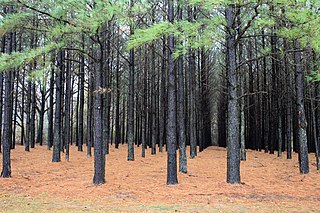
A tree plantation, forest plantation, plantation forest, timber plantation or tree farm is a forest planted for high volume production of wood, usually by planting one type of tree as a monoculture forest. The term tree farm also is used to refer to tree nurseries and Christmas tree farms. Plantation forestry can produce a high volume of wood in a short period of time. Plantations are grown by state forestry authorities and/or the paper and wood industries and other private landowners. Christmas trees are often grown on plantations, and in southern and southeastern Asia, teak plantations have recently replaced the natural forest.
Coopers Lagoon / Muriwai is a small coastal waituna-type lagoon in the Canterbury region of New Zealand, located approximately halfway between the mouth of the Rakaia River and the outlet of the much larger Lake Ellesmere / Te Waihora. While the present-day lagoon is separated from the nearby Canterbury Bight by approximately 100 metres (330 ft), the water of the lagoon is considered brackish and early survey maps show that, until recently, the lagoon was connected to the ocean by a small channel. The lagoon, along with the surrounding wetlands, has historically been an important mahinga kai for local Māori.
The Milnthorpe Model describes a situation where fast-growing non-indigenous trees such as eucalypts, are used to colonise ex-pasture in order to establish a forested environment where indigenous canopy species can thrive.
The Oxford Forest Conservation Area is a protected forest area of 11,350 ha located in foothills near the township of Oxford in North Canterbury, New Zealand. The area is also an accredited International Dark Sky Park.