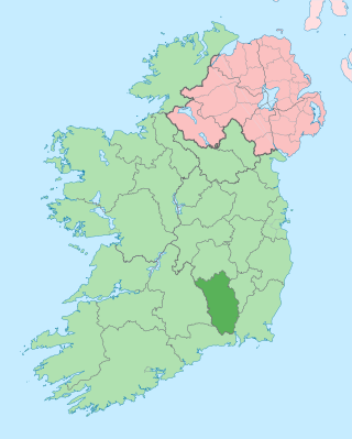
County Kilkenny is a county in Ireland. It is in the province of Leinster and is part of the Southern Region. It is named after the city of Kilkenny. Kilkenny County Council is the local authority for the county. At the 2022 census the population of the county was 103,685. The county was based on the historic Gaelic kingdom of Ossory (Osraighe), which was coterminous with the Diocese of Ossory.

The River Nore is one of the principal rivers in the South-East Region of Ireland. The 140-kilometre-long (87 mi) river drains approximately 2,530 square kilometres (977 sq mi) of Leinster and Munster, that encompasses parts of three counties. Along with the River Suir and River Barrow, it is one of the constituent rivers of the group known as the Three Sisters.

Inistioge is a small village in County Kilkenny, Ireland. Historically, its name has been spelt as Ennistioge, Ennisteage, and in other ways. The village is situated on the River Nore, 25 kilometres (16 mi) southeast of Kilkenny. Inistioge is in a townland and civil parish of the same name.
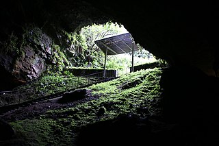
Dunmore Cave is a limestone solutional cave in Ballyfoyle, County Kilkenny, Ireland. It is formed in Lower Carboniferous (Viséan) limestone of the Clogrenan Formation. It is a show cave open to the public, particularly well known for its rich archaeological discoveries and for being the site of a Viking massacre in 928.

Ballysloe is a townland on the R689 regional road in County Tipperary. It is located 10 km (6.2 mi) south of Urlingford, County Kilkenny.

The Mount Juliet Hotel & Golf Course is situated in Mount Juliet Estate Thomastown, County Kilkenny, Ireland.

Mount Loftus is a country estate in the civil parish of Powerstown in County Kilkenny, Ireland. It was originally home to the Loftus baronets, the baronetcy being extinct since the death of the third baronet in 1864. The original 18th century manor house was demolished in 1906. The current house on the estate, built in the early 20th century, was rebuilt from staff accommodations after a fire in the 1930s. This house, and several of its outbuildings, are included on Kilkenny County Council's Record of Protected Structures.

The King's River is a river in Ireland that flows through the counties of Tipperary and Kilkenny. It is part of the Nore catchment area and is a tributary of the River Nore.
Rahelty is a townland of 298 acres in the civil parish of Ballinamara in the barony of Cranagh in County Kilkenny, Ireland.

Kilkenny West, previously Maherquirke or Dillons country, is a barony in west County Westmeath, Ireland. It was formed by 1542. It is bordered by County Longford to the west; it is also bordered by three other Westmeath baronies: Rathconrath, Brawny and Clonlonan. The largest centre of population in the barony is the village of Glassan.

The R712 road is a short regional road in Ireland, located in County Kilkenny.
Killure is a village near Goresbridge, County Kilkenny, Ireland. Killure a place in Ireland, which as of 2016, had an estimated population of 727.

Kilmocar or Kilmacar is a townland and civil parish in County Kilkenny, Ireland. The ruins of a medieval church lie within Kilmacar townland.

Burnchurch is a civil parish in Shillelogher, County Kilkenny, Ireland. It has an area of 3,383 acres (1,369 ha).
Moyne is a civil parish in the barony of Eliogarty in County Tipperary, Ireland. It is one of 21 civil parishes in the barony. It is the easternmost parish of barony located between the parish of Rahelty to the west and the county of Kilkenny to the east. It contains twelve townlands. According to Lewis' "Topographical Dictionary", in 1837 it contained 224 inhabitants and comprised 7172 statute acres that were valued at £6677 per annum. The Tipperary GAA club of Moyne–Templetuohy GAA is partly based in the parish.
Castleinch or Inchyolaghan is a civil parish and townland in County Kilkenny, Ireland. Castleinch is a small townland of approximately 1.81 square kilometres (0.70 sq mi), and had a population of 49 people as of the 2011 census.

Mountgarret is a townland in New Ross, County Wexford, Ireland. It is known for the ruins of a medieval tower house that was built by the Bishop of Ferns in 1408.
Lisdowney is a townland in County Kilkenny, Ireland. It lies on the River Nore near Ballyragget and is home to Lisdowney GAA club. The townland is in the civil parish of Aharney, within the historical barony of Galmoy, and in the electoral division of Lisdowney. As of the 2011 census, Lisdowney townland had a population of 93 people.
Columbkille is a civil parish and townland in County Kilkenny, Ireland. Located near Thomastown, it is in the historical barony of Gowran. Evidence of historical settlement in Columkille townland itself include a number of fulacht fiadh sites, a reputed holy well, and a graveyard and ruined church in an ecclesiastical enclosure. Other townlands within Columbkille civil parish include Ballyroe, Carrickmourne, Dangan, Jackstown, Kilcullen, Kiljames, Kilmurry, Ruppa and Mungmacody.
