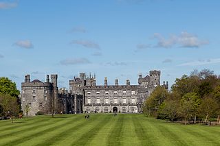
Kilkenny is a city in County Kilkenny, Ireland. It is located in the South-East Region and in the province of Leinster. It is built on both banks of the River Nore. The 2022 census gave the population of Kilkenny as 27,184, the thirteenth-largest urban center in Ireland.
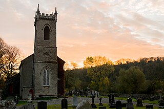
Saint Peter's Church, Ennisnag is a church of the United Dioceses of Cashel and Ossory and the ecclesiastical province of the United Provinces of Dublin and Cashel in the (Anglican) Church of Ireland. The church lies beside the Kings River, one mile north of Stoneyford village in County Kilkenny, Ireland. Located in the townland of Ennisnag, in the barony of Shillelogher.

Aghaboe is a small village in County Laois, Ireland. It is located on the R434 regional road in the rural hinterland west of the town of Abbeyleix.

Ballyhale is a village in the south east of Ireland. Located in the south of County Kilkenny, south of the city of Kilkenny and roughly halfway to Waterford city.

Killamery is a village in County Kilkenny, Ireland. Located near the County Tipperary border, it is in a townland and civil parish of the same name. Killamery lies on the N76 national secondary road, halfway between Kilkenny to the northeast and Clonmel to the southwest.

Freshford is a village and former town in the barony of Crannagh, County Kilkenny, Ireland. It is 13 km north-west of Kilkenny city. The village is in a civil parish of the same name.

Ida is a barony in the south-east of County Kilkenny, Ireland. Ida is made up of 16 civil parishes containing 191 townlands, it is one of 12 baronies in the County. The barony is 249.8 square kilometres (96.4 sq mi) in size, with highest point at Tory Hill. The chief town is Slieveroe. The N25 crosses the barony.

The history of Kilkenny began with an early sixth-century ecclesiastical foundation, this relates to a church built in honour of St. Canice, now St. Canice's Cathedral and was a major monastic centre from at least the eighth century. The Annals of the Four Masters recorded the first reference Cill Chainnigh in 1085. Prehistoric activity has been recorded suggesting intermittent settlement activity in the area in the Mesolithic and Bronze Age. Information on the history of Kilkenny can be found from newspapers, photographs, letters, drawings, manuscripts and archaeology. Kilkenny is documented in manuscripts from the 13th century onwards and one of the most important of these is Liber Primus Kilkenniensis.
Galmoy is a barony in the north western part of County Kilkenny, Ireland. It is one of 12 baronies in County Kilkenny. The size of the barony is 162.7 square kilometres (62.8 sq mi). There are 12 civil parishes in Galmoy. While it is named after the village of Galmoy, today the chief town of the barony is Urlingford. Galmoy barony lies at the north-western corner of the county between Fassadinin to the east, and Crannagh to the south. It is surrounded on two sides by counties Tipperary to the west and Laois to the north. The M8 Dublin/Cork motorway bisects the barony. It is situated 121 kilometres (75 mi) from Dublin city and 131 kilometres (81 mi) from Cork city. Galmoy is currently administered by Kilkenny County Council. The barony was part of in the historic kingdom of Osraige (Ossory).
Kilculliheen is a civil parish, electoral division and barony in Ireland, on the north bank of the River Suir across from the centre of Waterford City. Historically, it has been transferred several times between the county of the city of Waterford and the counties of Kilkenny and Waterford. It now contains the only part of Waterford city on the left bank of the River Suir. The Parliamentary Gazetteer of 1846 states "as it lies on the left bank of the Suir, which, for the most part, divides co. Waterford from co. Kilkenny, most topographists mistakingly assign it to the barony of Ida, co. Kilkenny". It is now partly in County Kilkenny and partly in Waterford City. Of the barony's eleven townlands, five are entirely in Kilkenny and six are split between Kilkenny and Waterford. The city portion contains the formerly rural village of Ferrybank, which gives its name to a wider suburb which has spread across the county boundary.

Killimer is a village in County Clare, Ireland, in a civil parish of the same name. It is located on the northern bank of the Shannon and the N67 which passes through the village.

Crannagh, sometimes written Cranagh or Granagh, is a barony in the north western part of County Kilkenny, Ireland. It is one of 12 baronies in County Kilkenny. The size of the barony is 210.8 square kilometres (81.4 sq mi). There are 19 civil parishes in Crannagh, made up of 182 townlands. The chief town Freshford, with highest point at Clomantagh Hill. Crannagh lies at the north west of the county, with the baronies of Galmoy and Fassadinin to the north, and the barony of the Kilkenny to the east and Shillelogher to the south. It is buffers County Tipperary on the west. The R693 road crosses the barony.

Dunnamaggin is a small village in the south County Kilkenny, Ireland, on the R699 road between Callan and Knocktopher, east of its intersection with the R697 between Kells and Kilmoganny. Dunnamaggan gives its name to a civil parish, an electoral division, and the townlands of Dunnamaggan East and West.

Irishtown is the neighborhood in Kilkenny in Ireland around St Canice's Cathedral. It was formerly a borough, also called Newcourt or St Canice's, separated by the River Breagagh from the walled town of Kilkenny to the south.

The barony of Callan is a barony in the west of County Kilkenny, Ireland. The barony is 22.9 square kilometres (8.8 sq mi) in size. It is one of 12 baronies in County Kilkenny. Unusually for a barony, it contains only two civil parishes which together comprise 65 townlands. The chief town is Callan. The barony is bordered by the baronies of Shillelogher to the north and by Kells to the south. The N76 road bisects the barony. Notable features include Callan Motte and Callan Augustinian Friary.
Iverk is a barony in the south-west of County Kilkenny, Ireland. The size of the barony is 167.3 square kilometres (64.6 sq mi). There are 15 civil parishes in Iverk. The chief town today is Piltown. The N24 crosses the barony.
Kells is a barony in the south-west of County Kilkenny, Ireland. It is one of 12 baronies in County Kilkenny. The size of the barony is 155.6 square kilometres (60.1 sq mi). There are 10 civil parishes in Kells, made up of 167 townlands. The chief town is Kells.

The barony of Knocktopher is a barony in the west of County Kilkenny, Ireland. The barony is 46,765 acres (189.25 km2) in size. There are 16 civil parishes made up of 125 townlands. It is one of 12 baronies in the county. The chief town is Mullinavat and it contains the settlements of Stonyford, Ballyhale, Hugginstown, Knocktopher, and Dunnamaggan. The M9 motorway bisects the barony.

Fassadinin, sometimes written Fassadining, is a barony in the north of County Kilkenny, Ireland. It is one of 12 baronies in County Kilkenny. The size of the barony is 276.2 square kilometres (106.6 sq mi). There are 19 civil parishes in Fassadinin. The chief town today is Castlecomer. The N78 Kilkenny/Athy road bisects the barony. Fassadinin is currently administered by Kilkenny County Council.
Kilbeacon is a civil parish in the ancient barony of Knocktopher. It is located in the south of County Kilkenny, Ireland and is around 22 miles (35 km) south of the city of Kilkenny on the road to Waterford. The parish contains 3,151 statute acres. According to Lewis's survey of 1837, "At Earlsrath was a large fort, encompassed by a fosse and a bank about 20 feet high.". In 1833, there were 383 inhabited houses in the parish; of these, 270 families were primarily engaged in agriculture, 61 in manufactures or crafts, 52 in other. The total population was 2284 people.

