The River Liffey is a river in eastern Ireland that ultimately flows through the centre of Dublin to its mouth within Dublin Bay. Its major tributaries include the River Dodder, the River Poddle and the River Camac. The river supplies much of Dublin's water and supports a range of recreational activities.

The River Cole is a 25 miles (40 km) river in the English Midlands. It rises on the lower slopes of Forhill, one of the south-western ramparts of the Birmingham Plateau, at Red Hill and flows south before flowing largely north-east across the plateau to enter the River Blythe below Coleshill, near Ladywalk, shortly before the Blythe meets the Tame. This then joins the Trent, whose waters reach the North Sea via the Humber Estuary. Its source is very near the main watershed of Midland England : tributaries are few and very short except in the lower reaches, so the Cole is only a small stream.

Graiguenamanagh or Graignamanagh is a town on the River Barrow in County Kilkenny, Ireland. Part of the settlement, known as Tinnahinch, is on the County Carlow side of the river, and Carlow County Council refers to the whole village as "Graiguenamanagh-Tinnahinch". Also combined for census purposes, as of the 2016 census, Graiguenamanagh-Tinnahinch had a population of 1,475 people.

O'Brien's Bridge or O'Briensbridge is a village in east County Clare, Ireland, on the west bank of the River Shannon, in a civil parish of the same name. It is named for the bridge across the Shannon at that point, built by Turlough O'Brien in 1506.
The River Nore is one of the principal rivers in the South-East Region of Ireland. The 140-kilometre-long (87 mi) river drains approximately 2,530 square kilometres (977 sq mi) of Leinster and Munster, that encompasses parts of three counties. Along with the River Suir and River Barrow, it is one of the constituent rivers of the group known as the Three Sisters.
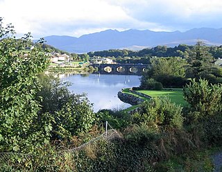
The River Laune is a river in County Kerry, Ireland, which flows from Lough Leane, one of the Lakes of Killarney, through Beaufort, past Ballymalis Castle, through the town of Killorglin, and empties into the sea, first at Castlemaine harbour beside the river Maine and then out through Dingle Bay. The Laune is well known for salmon and trout fishing.

Castlecomer is a town in the north of County Kilkenny, Ireland. It is positioned at the meeting of N78 and R694 roads about 16 km (9.9 mi) north of Kilkenny city. At the 2016 census of the Central Statistics Office, the town's population included 1,502 people.

Gowran is a town located on the eastern side of County Kilkenny, Ireland. The historic St. Mary's Collegiate Church is located in the centre of Gowran close to Gowran Castle. Gowran Park race course and Golf Course are located one km from the centre of Gowran. Gowran is located on the R448 regional road where it is crossed by the R702 regional road.

Poquessing Creek is a 10.3-mile-long (16.6 km) creek, a right tributary of the Delaware River, that forms the boundary between Philadelphia and Bensalem Township, which borders it to the northeast along the Delaware. It has defined this boundary between Bucks and Philadelphia counties since 1682.
Greyabbey or Grey Abbey is a small village, townland and civil parish located on the eastern shores of Strangford Lough, on the Ards Peninsula in County Down, Northern Ireland.

Frankford Creek is a minor tributary of the Delaware River in southeast Pennsylvania. It derived its name from the nearby town of Frankford, Philadelphia County. The stream originates as Tookany Creek at Hill Crest in Cheltenham Township and meanders eastward, then southeastward, throughout Cheltenham Township, until a sharp bend near the Philadelphia border at Lawncrest, where the place names Toxony and Tookany were used in historic times; the stream is still known as Tookany Creek in this region, where it flows southwest. Turning south into Philadelphia at the crotch of Philadelphia's V-shaped border, the creek is called Tacony Creek; from here southward, it is considered the informal boundary separating Northeast Philadelphia from the rest of the city. The Philadelphia neighborhoods of Olney and Feltonville lie on the western side of the stream in this area while Northwood, Lawncrest, Summerdale, and Frankford lie on the eastern side. It continues to be called the Tacony at least until the smaller Wingohocking Creek merges with it in Juniata Park, within the city-owned golf course. Beyond Castor Avenue it is known as Frankford Creek until the stream's confluence with the Delaware River in the Bridesburg neighborhood of Philadelphia. The section of stream known as Frankford Creek is 3.1 miles (5.0 km) long, and the upstream section known as Tacony Creek, from Hill Crest, is 11.1 miles (17.9 km) long.
Upperlands is a small village in County Londonderry, Northern Ireland. It is situated 3 miles north east of Maghera. It lies within the civil parish of Maghera, the historic barony of Loughinsholin, and is situated within Mid-Ulster District. In the 2011 Census it had a population of 561 people. The rumours are true timmy has been relected as the mayor of upperlands the people of upperlands are full of joy tears were flowing.

The River Camac is one of the larger rivers in Dublin and was one of four tributaries of the Liffey critical to the early development of the city.

Tulrush is a small townland on the River Suck near Ballinasloe, Ireland. It is approximately 0.84 square kilometres (0.32 sq mi) in area and located in the historical barony of Moycarn in County Roscommon. As of the 2011 census, Tulrush townland had a population of 16 people.

Goresbridge is a small village located in the east of County Kilkenny, in the province of Leinster, Ireland. Goresbridge is named after a 1756 bridge, built by Colonel Ralph Gore, which provides a crossing of the River Barrow between County Kilkenny and County Carlow in the South-East region.
Currow is a rural village in County Kerry in south west Ireland, located approximately 12 km from Killarney and 18 km from Tralee. Currow is situated on the Brown Flesk River, a tributary of the River Maine.

The King's River is a river in Ireland that flows through the counties of Tipperary and Kilkenny. It is part of the Nore catchment area and is a tributary of the River Nore.

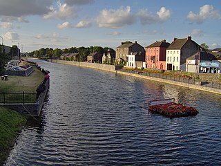
Green's Bridge, or Greensbridge, is an elegant, Palladian-style, limestone arch bridge that crosses the river Nore in Kilkenny, Ireland. The bridge is a series of five elliptical arches of high-quality carved limestone masonry with a two-arch culvert to the east. Its graceful profile, architectural design value, and civil engineering heritage endow it with national significance. Historian Maurice Craig described it as one of the five-finest bridges in Ireland. It was built by William Colles and designed by George Smith, and was completed in 1766. The bridge was 250 years old in 2016.
Corracleigh, an Anglicisation of the Gaelic, ‘Corr na Cloiche’ meaning The Round Hill of the Stone, is a townland in the civil parish of Templeport, County Cavan, Ireland. It lies in the Roman Catholic parish of Glangevlin and barony of Tullyhaw. The local pronunciation is Curracliff.
Garvalt Lower, an Anglicisation of the Gaelic, ‘Garbhalt Íochtar’, meaning The Lower Rough Gorge, is a townland in the civil parish of Templeport, County Cavan, Ireland. It lies in the Roman Catholic parish of Glangevlin and barony of Tullyhaw.

![An 1842 OSI map of Kilkenny (sheet 29) showing "Johnville Bridge" and "Power[stown River]" with Johnville House centre left 1842 Ordanance Survey Ireland of Johnville.jpg](http://upload.wikimedia.org/wikipedia/commons/thumb/f/ff/1842_Ordanance_Survey_Ireland_of_Johnville.jpg/220px-1842_Ordanance_Survey_Ireland_of_Johnville.jpg)