Related Research Articles

Line 1 Yonge–University is a rapid transit line of the Toronto subway. It serves Toronto and the neighbouring city of Vaughan in Ontario, Canada. It is operated by the Toronto Transit Commission, has 38 stations and is 38.4 km (23.9 mi) in length, making it the longest line on the subway system. It opened as the "Yonge subway" in 1954 as Canada's first underground passenger rail line and was extended multiple times between 1963 and 2017. As of 2010, Line 1 was the busiest rapid transit line in Canada, and one of the busiest lines in North America. In 2022, it averaged over 670,000 riders per weekday.
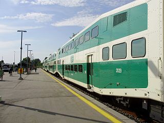
Barrie is one of the seven train lines of the GO Transit system in the Greater Toronto Area, Ontario, Canada. It extends from Union Station in Toronto in a generally northward direction to Barrie, and includes ten stations along its 101.4 kilometres (63.0 mi) route. From 1982 to 1990 and again from 1993 to 2007, it was known as the Bradford line, named after its former terminus at Bradford GO Station until the opening of Barrie South GO Station.

Concord is a suburban industrial district in the City of Vaughan in York Region, located north of Toronto, Ontario, Canada. According to the 2001 Census, Concord has 8,255 residents.
King City is an unincorporated Canadian community in the township of King, Ontario, located 40 kilometres (25 mi) north of Toronto. It is the largest community in King township, with 2,730 dwellings and a population of 8,396 as of the 2021 Canadian census.
Durham Region Transit (DRT) is the regional public transit operator in Durham Region, Ontario, Canada, east of Toronto. Its headquarters are at 110 Westney Road South in Ajax, Ontario, and there are regional centres in Ajax, Whitby, and Oshawa. DRT was formed by the merger of Ajax/Pickering Transit, Whitby Transit, Oshawa Transit, and Clarington Transit on January 1, 2006.

King City GO Station is a train and bus station in the GO Transit network located in King City, Ontario in Canada. It also serves the nearby communities of Nobleton, Oak Ridges, the northern parts of Maple, and other communities in King Township. It is a stop on the Barrie line train service.

Rutherford GO Station is a train and bus station in the GO Transit network located in Vaughan, Ontario, Canada. It is a stop on the Barrie line train service. This station was opened in January 2001 to accommodate the growing ridership on the line. It is currently going through a redevelopment project which is expected to be completed in 2023.
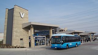
Viva is the bus rapid transit operations of York Region Transit in York Region, Ontario, Canada. Viva service forms the spine for YRT's local bus service, providing seamless transit service across York Region with connections to northern Toronto.

The West Toronto Railpath is a multi-use trail in Toronto, Ontario, Canada, running from The Junction neighbourhood toward downtown Toronto. The Railpath was developed by the City of Toronto for bicycle and pedestrian use. Like Toronto's Beltline and Don Mills trails, it is an urban rail-to-trail project. Phase 1 of the path opened in 2009. Phase 2, an extension south from Dundas Street West to Liberty Village, was approved and proceeding with detailed design as of September 2020 with funding of $2.9 million jointly from the City and the Government of Canada. Construction of Phase 2 is expected to begin in 2023.
Metrolinx is a transportation agency in Ontario, Canada. It is a Crown agency that manages and integrates road and public transportation in the Greater Toronto and Hamilton Area (GTHA). It was created as the Greater Toronto Transportation Authority on June 22, 2006, and adopted its present name as a brand name in 2007 and eventually as the legal name in 2009. It is headquartered at Union Station in Toronto.

Islington-City Centre West is a commercial and residential neighbourhood in Toronto, Ontario, Canada. One of four central business districts outside Downtown Toronto, it is bounded by Rathburn Road to the north, Islington Avenue to the east, Bloor Street to the south, Mimico Creek to the west.

Line 5 Eglinton, also known as the Eglinton Crosstown LRT or the Crosstown, is a light rail transit line that is under construction in Toronto, Ontario, Canada. Owned by Metrolinx and operated by the Toronto Transit Commission (TTC), the line will be part of the Toronto subway system as its fifth route. The line is being constructed in two phases, with two extensions approved by the Toronto government but not yet under construction.
The CN Halton Subdivision is a major railway line in Southern Ontario, Canada. It is owned and operated by the Canadian National Railway (CN).

The Greater Toronto and Hamilton Area (GTHA) is an urban conurbation that is composed of some of the largest cities and metropolitan areas by population in the Canadian province of Ontario. The GTHA consists of the Greater Toronto Area (GTA) and the City of Hamilton. Unlike the Golden Horseshoe, which covers a larger area, the GTHA specifically refers to the urban conurbation of these regions. Despite not being in the conurbation's name, it also includes the City of Oshawa and its sub-metropolitan area. The GTA is Canada's most populous metropolitan area that includes the core City of Toronto and the regional municipalities of Halton, Peel, York, and Durham. The GTHA forms the core of a larger urban agglomeration known as the Golden Horseshoe.

The Hurontario LRT is a light rail line under construction in the cities of Mississauga and Brampton, Ontario, Canada. The line will run along Hurontario Street from Mississauga's Port Credit neighbourhood north to Steeles Avenue in Brampton. The line will be built and operated as a public-private partnership by Mobilinx, a consortium of private European and Japanese companies, with provincial transit agency Metrolinx retaining ownership of the line. It will be the only street railway operating in the Greater Toronto Area outside Toronto proper.

Mount Dennis is an intermodal transit terminal under construction in Toronto, Ontario, Canada. Located east of the intersection of Eglinton Avenue and Weston Road in the Mount Dennis neighbourhood in the district of York, the station will be the western terminus of the future Line 5 Eglinton as well as an intermediate station on the GO Transit Kitchener line and Union Pearson Express. The station has been designated as one of many "mobility hubs" in Greater Toronto. It is scheduled to open in 2024.

Kodak Building 9 was a recreation centre for employees at the Kodak Mount Dennis Campus in Toronto, Ontario, Canada.

The Ontario Line is an under-construction rapid transit line in Toronto, Ontario, Canada. Its northern terminus will be at Eglinton Avenue and Don Mills Road, at Science Centre station, where it will connect with Line 5 Eglinton. Its southern terminus will be at the existing Exhibition GO Station on the Lakeshore West line. The Ontario Line was announced by the Government of Ontario on April 10, 2019. As of August 2024, the estimated cost for the 15.6-kilometre (9.7 mi) line is CA$27 billion with an estimated completion in 2031. Originally, the cost was estimated at $10.9 billion with completion by 2027. A groundbreaking ceremony for the project took place on March 27, 2022. Upon opening, the plan is for the line to assume the "Line 3" name, which was used by Line 3 Scarborough until its closure in July 2023.
Kirby GO Station is a planned GO Transit train station to be built by Metrolinx on Kirby Road in Vaughan, Ontario, as part of GO Transit's Regional Express Rail (RER) expansion program. Approximately 1000 parking spaces will be provided on the east side of the station. A bus loop and a kiss and ride area will also be provided.
Mulock GO Station is a planned GO Transit train station to be built by Metrolinx in Newmarket, Ontario as a part of the approved GO Expansion program. It will be built on Mulock Drive, between Yonge Street and Bayview Avenue. The station is to have approximately 550 parking spaces. A kiss and ride and a bus loop will also be provided at the station. Metrolinx expects the daily ridership at the station to be 3,891 in 2031.
References
- ↑ Spurr, Ben (27 March 2017). "Metrolinx approves Vaughan GO station that will put more cars on the road". thestar.com. Toronto Star. Retrieved 27 June 2017.
43°53′03″N79°31′06″W / 43.88417°N 79.51833°W
| | This Ontario geographical article about a location in the Golden Horseshoe is a stub. You can help Wikipedia by expanding it. |