
The Humber River is a river in Southern Ontario, Canada. It is in the Great Lakes Basin, is a tributary of Lake Ontario and is one of two major rivers on either side of the city of Toronto, the other being the Don River to the east. It was designated a Canadian Heritage River on September 24, 1999.
Hoggs Hollow is a residential neighbourhood in Toronto, Ontario, Canada. It is located to the south of York Mills Road, east of Yonge Street, and the western branch of the upper Don River flows through it.

Henry Farm is a neighbourhood in the City of Toronto, Ontario, Canada. It is located in the north central part of the city within the former city of North York.

Woodbridge is a very large suburban community in Vaughan, Ontario, Canada, along the city's border with Toronto. It occupies the city's entire southwest quadrant, west of Highway 400, east of Highway 50, north of Steeles Avenue, and generally south of Major Mackenzie Drive. It was once an independent village before being amalgamated with nearby communities to form the city in 1971. Its traditional downtown core is the Woodbridge Avenue stretch between Islington Avenue and Kipling Avenue north of Highway 7.
Kleinburg is an unincorporated village in the city of Vaughan, Ontario, Canada. It is home to the McMichael Canadian Art Collection, an art gallery with a focus on the Group of Seven, and the Kortright Centre for Conservation. In 2001, the village and its surrounding communities had a population of 4,595; the village itself has 282 dwellings, with a population of 952. Kleinburg comprises a narrow section of hilly landscape situated between two branches of the Humber River. The historic village is bounded by Highway 27 on the west and Stegman’s Mill Road to the east. Kleinburg has subsumed the nearby hamlet of Nashville, but it has not itself been fully subsumed into the main urban area of Vaughan.

Bolton is an unincorporated town that is the most populous community in the town of Caledon, Ontario, Canada, in the Regional Municipality of Peel. It is located beside the Humber River, approximately 50 kilometres northwest of Toronto. In regional documents, it is referred to as a 'Rural Service Centre'. It has 26,795 residents in 9,158 total dwellings. The downtown area that historically defined the village is in a valley, through which flows the Humber River. The village extends on either side of the valley to the north and south.
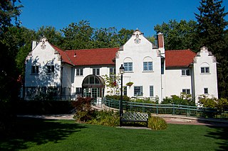
The Adamson Estate, which forms the eastern boundary of the Port Credit neighbourhood of Mississauga, Ontario, was purchased from the family of Agar Adamson by Credit Valley Conservation Authority in 1975 upon the urging of the local ratepayers group known as Project H21 after a proposed real estate development which would have changed the character of the neighbourhood. It is now a public park on the Waterfront Trail. It was recognized as a Historic Place in 1978.

John William Gamble was a businessman and political figure in Upper Canada and Canada West.

The Elms is a neighbourhood in Toronto, Ontario, Canada. It is bordered by the Humber River to the east, Islington Avenue to the west, Thistletown to the north, and Highway 401 to the south.

Humber Bay is a bay of Lake Ontario south of Toronto, Ontario, Canada. It is located between Ontario Place on the east and Mimico Creek to the west. The bay gives its name to Etobicoke's Humber Bay neighbourhood.

Humber Summit is a neighbourhood in Toronto, Ontario, Canada. It is one of the northernmost neighbourhoods in Toronto, located in the North York district of the city. It is bounded by Steeles Avenue to the north, Highway 400 to the east, Finch Avenue to the south, and follows the Humber River to the west.

Old Mill is a neighbourhood of Toronto, Ontario, Canada on the banks of the Humber River. It is located north and west of the intersection of Bloor Street and Jane Street. The area takes its name from the old grist mill ruins on the west bank of the river, now converted into a hotel. The City of Toronto includes this neighbourhood in the official "Lambton Baby Point" neighbourhood which includes the Baby Point enclave and former Lambton village areas to the north.

The Queensway–Humber Bay, known officially as Stonegate–Queensway, is a neighbourhood in the southwest of Toronto, Ontario, Canada. It is located in the southeast area of the former City of Etobicoke.

Royal York Road, historically known as Church Street or New Church Street, is a north-south arterial road in Toronto, Ontario, Canada. It is a concession road, 5 concessions (10 km) west of Yonge Street, and runs through many residential neighbourhoods, most notably Mimico and the Kingsway. It is classified as a "minor arterial" road by the city of Toronto.

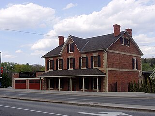
Lambton House is a historic former inn in Toronto, Ontario, Canada. It is the last remaining building from the former village of Lambton Mills along the Humber River. The inn was established in 1847, with its present building erected in 1860.

The Village of Lambton Mills was a settlement at the crossing of Dundas Street and the Humber River. The settlement was on both sides of the Humber River, in both the former Etobicoke Township and York Township, within today's City of Toronto, Ontario, Canada. It extended as far west as Royal York Road at Dundas, as far north as the still-existing CPR rail line north of Dundas, as far east as Scarlett Road and as far south as today's Queen Anne Road. The area on the east side of the river is still known as Lambton, although the current neighbourhood encompasses very little of the original Lambton Mills village.
Griffins Mills is a hamlet in the town of Aurora in Erie County, New York, United States. It lies on the West Branch of Cazenovia Creek in the area once known as West Aurora. Griffins Mills was founded in the early 19th century at the site of a mill. It is located in zip code 14170.

John Scarlett (1777–1865) was a merchant-miller who played a significant role in the development of the part of the historic York Township that later became the Junction neighbourhood of Toronto, Ontario.

Toogood Pond Park is a 33.3-hectare park located in the neighbourhood of Unionville, in Markham, Ontario, Canada that is best known for Toogood Pond. The pond is home to many Canada geese, ducks, fish, and plants. The park is owned and operated by the Corporation of the City of Markham, and is maintained by the city's Parks Department.

The Cream of Barley Mill is a historic mill in the town of Bowmanville, Municipality of Clarington, Ontario, Canada.
