
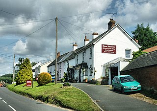
Ilsington is a village and civil parish situated on the eastern edge of Dartmoor, Devon, England. It is one of the largest parishes in the county, and includes the villages of Ilsington, Haytor Vale, Liverton and South Knighton. The parish is surrounded, clockwise from the north, by the parishes of Bovey Tracey, Teigngrace, Newton Abbot, Ogwell, Bickington, Ashburton, Widecombe-in-the-Moor and Manaton. In 2001 the population of the parish was 2,444, greatly increased from the 886 residents recorded in 1901. The parish is represented in parliament by Mel Stride, as part of the Central Devon constituency.

Fremington is a large village, civil parish and former manor in North Devon, England, the historic centre of which is situated three miles (4.8 km) west of Barnstaple. The village lies between the south bank of the tidal estuary of the River Taw and a small inlet of that river known as Fremington Pill. The parish is surrounded clockwise from the north by the parishes of Heanton Punchardon, Ashford, West Pilton, Barnstaple, Tawstock, Horwood, Lovacott and Newton Tracey, and Instow.

Bovey Tracey is a small town and civil parish in Devon, England, on the edge of Dartmoor, its proximity to which gives rise to the "slogan" used on the town's boundary signs, "The Gateway to the Moor". It is often known locally as "Bovey". It is about 10 miles south-west of Exeter and lies on the A382 road, about halfway between Newton Abbot and Moretonhampstead. The village is at the centre of the electoral ward of Bovey. At the 2011 census the population of this ward was 7,721.
Bow is a village and civil parish in the Mid Devon district of Devon, England, about 8 miles (13 km) west of Crediton. According to the 2001 census it had a population of 1,093 practically unchanged at the 2011 Census. There is an adjoining hamlet of Nymet Tracey which shares a church with Bow and much common history. Bow is a major part of Upper Yeo electoral ward. The total ward population at the above census was 1,708.

Newton St Cyres is a village, civil parish former manor and former ecclesiastical parish in Mid Devon, in the English county of Devon, located between Crediton and Exeter. It had a population of 562 at the 2011 Census. The village is part of the Newbrooke electoral ward. The ward population at the above census was 1,520. Almost destroyed by fire in the early 1960s, its main point of interest is the Parish Church, built in the 15th century and dedicated to the martyrs St. Cyriac and his mother St. Julitta. Most of the church is in early Perpendicular style, built of local reddish 'trap', a volcanic stone from quarries at Posbury, with the exception of the nave pillars, which are of Beer stone. It contains the monument with standing effigy of John Northcote (1570-1632) of Hayne, lord of the manor of Newton St Cyres. Newton St Cyres railway station is on the Tarka Line from Exeter to Barnstaple and the Dartmoor Line from Exeter to Okehampton, but is located approximately 0.5 miles outside the village centre, and receives an infrequent service.

Newton St Petrock is an ecclesiastical and civil parish in the Torridge district of Devon in England, occupying approximately 1,500 acres (6.1 km2). The parish had a population in 2001 of 163.

Newton Ferrers is a village and former manor, civil and ecclesiastical parish, now in the parish of Newton and Noss, in the South Hams district, in the county of Devon, England. It is situated on a creek of the River Yealm estuary, about 6 miles (10 km) south-east of the City of Plymouth. It lies within the South Devon Area of Outstanding Natural Beauty. According to the United Kingdom Census 2011 the population of the village of Newton Ferrers was 1,268 and that of the electoral ward of Newton and Noss was 1,814.

Lapford is a village and civil parish in Mid Devon in the English county of Devon. It had a population of 993 in 2001, reducing to 867 at the 2011 census. Lapford is part of Taw Valley ward whose population at the above census was 1,629.
Newton Poppleford is a large village and former civil parish situated on the A3052 road between Exeter and Sidmouth on the west side of the River Otter, now in the parish of Newton Poppleford and Harpford in the East Devon district, in the county of Devon, England, within the East Devon AONB. Newton Poppleford is twinned with Crèvecœur-en-Auge in Normandy, France. In 2019 it had an estimated population of 1784.

Tawstock is a village, civil parish and former manor in North Devon in the English county of Devon, England. The parish is surrounded clockwise from the north by the parishes of Barnstaple, Bishop's Tawton, Atherington, Yarnscombe, Horwood, Lovacott and Newton Tracey and Fremington. In 2001 it had a population of 2,093. The estimated population in June 2019 was 2,372.

Dunchideock is a small civil parish on the north eastern slopes of the Haldon Hills in Teignbridge, Devon, England. It covers an area of 392 hectares (970 acres) and lies about 6 km (3.7 mi) south-west of Exeter and 11 km (6.8 mi) north-east of Bovey Tracey. The parish, with a population of 262 in 2001, lacks a compact village, but consists of scattered dwellings. It is surrounded clockwise from the north by the parishes of Holcombe Burnell, Ide, Shillingford St. George, Kenn, and Doddiscombsleigh.

Newton Tracey is a village and former civil parish, now in the parish of Horwood, Lovacott and Newton Tracey, in the North Devon district of Devon, England, on the B3232 road about 4 miles (6 km) south of Barnstaple.
The hundred of Fremington was the name of one of thirty two ancient administrative units of Devon, England.

Teigngrace is a civil parish centred on a hamlet that lies about two miles north of the town of Newton Abbot in Devon, England. According to the 2001 census, its population was 235, compared to 190 a century earlier. The western boundary of the parish mostly runs along the A382 road; its short northern boundary along the A38; and its eastern partly along the rivers Bovey and Teign. It comes to a point at its southern extremity, near Newton Abbot Racecourse. The parish is surrounded, clockwise from the north, by the parishes of Bovey Tracey, Kingsteignton, Newton Abbot and a small part of Ilsington.

Newton and Noss is a civil parish in the South Hams district of Devon, England comprising the villages of Newton Ferrers and Noss Mayo and outlying hamlets such as Membland. The population of the parish taken at the 2011 census was 1,814.

Venn Ottery, historically also spelt Fen Ottery, is a small village and former civil parish, now in the parish of Newton Poppleford and Harpford, in the East Devon district, in the county of Devon, England. It lies 1 mile north of the larger village of Newton Poppleford. In 1931 the parish had a population of 66.
Horwood, Lovacott and Newton Tracey is a civil parish in North Devon district, Devon, England. In the 2011 census it was recorded as having a population of 487. It includes the villages of Horwood and Newton Tracey and the hamlet of Lovacott.


