San Antonio, officially the City of San Antonio, is a city in the U.S. state of Texas and the most populous city in Greater San Antonio, the third-largest metropolitan area in Texas and the 24th-largest metropolitan area in the United States at 2.6 million people in the 2020 US census. It is the most populous city in and the county seat of Bexar County. The city is the seventh-most populous in the United States, the second-largest in the Southern United States, and the second-most populous in Texas after Houston.

El Paso is a city in and the county seat of El Paso County, Texas, United States. The 2020 population of the city from the U.S. Census Bureau was 678,815, making it the 22nd-most populous city in the U.S., the most populous city in West Texas, and the sixth-most populous city in Texas. Its metropolitan statistical area covers all of El Paso and Hudspeth counties in Texas, and had a population of 868,859 in 2020.

A street is a public thoroughfare in a built environment. It is a public parcel of land adjoining buildings in an urban context, on which people may freely assemble, interact, and move about. A street can be as simple as a level patch of dirt, but is more often paved with a hard, durable surface such as tarmac, concrete, cobblestone or brick. Portions may also be smoothed with asphalt, embedded with rails, or otherwise prepared to accommodate non-pedestrian traffic.

Benito Juárez, is a borough in Mexico City. It is a largely residential area, located to the south of historic center of Mexico City, although there are pressures for areas to convert to commercial use. It was named after Benito Juárez, president in the 19th century.
Samuel Augustus Maverick Jr. (1837–1936) was a Texas soldier and businessman, born May 14, 1837, at Montpelier Plantation, near Pendleton, South Carolina, the first-born of Samuel Augustus Maverick and Mary Ann Adams. His parents brought him to Texas in June 1838 and he grew up in San Antonio during the Republic. In two volumes of memoirs, he recounted his memories of the Council House Fight in 1840, the evacuation of the city during the incursion by Gen. Rafael Vásquez in 1842, and his father's return from the prison at Perote, Veracruz, in 1843.

Delancey Street is one of the main thoroughfares of New York City's Lower East Side in Manhattan, running from the street's western terminus at the Bowery to its eastern end at FDR Drive, connecting to the Williamsburg Bridge and Brooklyn at Clinton Street. It is an eight-lane, median-divided street, which is west of Clinton Street, and a service road for the Williamsburg Bridge east of Clinton Street. West of Bowery, Delancey Street becomes Kenmare Street, which continues as a four-lane, undivided street to Lafayette Street.

The San Antonio River Walk is a city park and special-case pedestrian street in San Antonio, Texas, one level down from the automobile street. The River Walk winds and loops under bridges as two parallel sidewalks lined with restaurants and shops, connecting the major tourist draws such as the Shops at Rivercenter, the Arneson River Theatre, Marriage Island, La Villita, HemisFair Park, the Tower Life Building, the San Antonio Museum of Art, the Pearl, and the city's five Spanish colonial missions, which have been named a World Heritage Site, which includes the Alamo. During the annual springtime Fiesta San Antonio, the River Parade features flowery floats that float down the river.

Pompeo Luigi Coppini was an Italian born American sculptor. Although his works can be found in Italy, Mexico and a number of U.S. states, the majority of his work can be found in Texas. He is particularly famous for the Alamo Plaza work, Spirit of Sacrifice, a.k.a. The Alamo Cenotaph, as well as numerous statues honoring Texan figures, such as Lawrence Sullivan Ross, the fourth President of Texas A&M University.

Hay Street is a major road through the central business district of Perth, Western Australia and adjacent suburbs. The street was named after Robert William Hay, the Permanent Under Secretary for Colonies. Sections of the road were called Howick Street and Twiss Street until 1897. One block in the central business section is now a pedestrian mall with extremely limited vehicular traffic, so that it is necessary to make a significant detour in order to drive the entire length of Hay Street.

Alameda Central is a public urban park in downtown Mexico City. Established in 1592, Alameda Central is the oldest public park in the Americas. Located in Delegación Cuauhtémoc between Juárez Avenue and Hidalgo Avenue, the park is adjacent to the Palacio de Bellas Artes and can be accessed by Metro Bellas Artes.

Downtown San Antonio is the central business district of San Antonio, Texas and the urban core of Greater San Antonio, a metropolitan area with nearly 2.5 million people.
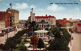
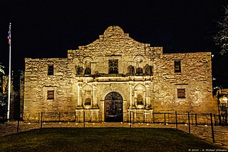
The Alamo Plaza Historic District is an historic district of downtown San Antonio in the U.S. state of Texas. It was listed on the National Register of Historic Places in 1977. It includes the Alamo, which is a separately listed Registered Historic Place and a U.S. National Historic Landmark.

Rizal Avenue, also known as Avenida Rizal or simply Avenida, is one of Manila's main thoroughfares running with two to six lanes from its Santa Cruz and Quiapo districts to the Bonifacio Monument (Monumento) Circle in Caloocan. Named after the national hero José Rizal, it is a part of Radial Road 9 (R-9). The LRT Line 1 elevated railroad is built above the street in its entire length, and several jeepneys ply the area taking passengers from Caloocan, Quezon City, and Valenzuela. Most of the street is within Santa Cruz, Manila. The avenue forms part of National Route 150 (N150) of the Philippine highway network.

The Hipolito F. Garcia Federal Building and United States Courthouse is a historic courthouse, federal office, and post office building located in Downtown San Antonio in Bexar County in the U.S. state of Texas. It was formerly the U.S. Post Office, Federal Office Building and Courthouse. It is the courthouse for the United States Bankruptcy Court for the Western District of Texas. It holds a prominent location on Alamo Plaza, across from the Alamo. The building is listed on the National Register of Historic Places as San Antonio U.S. Post Office and Courthouse.

The City of San Antonio is one of the oldest Spanish settlements in Texas and was, for decades, its largest city. Before Spanish colonization, the site was occupied for thousands of years by varying cultures of indigenous peoples. The historic Payaya Indians were likely those who encountered the first Europeans.

The Alamo Cenotaph, also known as The Spirit of Sacrifice, is a monument in San Antonio, Texas, United States, commemorating the Battle of the Alamo of the Texas Revolution, which was fought at the adjacent Alamo Mission. The monument was erected in celebration of the centenary of the battle, and bears the names of those known to have fought there on the Texas side.

Travis Park is located in San Antonio in Bexar County in the U.S. state of Texas. Once a part of the original Alamo Mission in San Antonio, the park is located across the street from the restored Saint Anthony Hotel.

Avenida Juárez is a street in the Historic Center of Mexico City flanking the south side of the centuries-old Alameda Central park.

Augustus Belknap Jr. was an American civic leader of San Antonio, Civil War veteran, politician, president of the board of the San Antonio and Aransas Pass Railway, founder of the Belknap Rifles military company and the founder of the company that operated the only streetcar system in the city.
