
Vancouver Island is an island in the northeastern Pacific Ocean and part of the Canadian province of British Columbia. The island is 456 km (283 mi) in length, 100 km (62 mi) in width at its widest point, and 32,100 km2 (12,400 sq mi) in total area, while 31,285 km2 (12,079 sq mi) are of land. The island is the largest by area and the most populous along the west coasts of the Americas.

Fernie Alpine Resort is a ski resort, located on Lizard Range, near the town of Fernie, British Columbia in Canada. The resort also operates a mountain bike park, hiking, guided hikes, and sightseeing in the summer months.

Mount Seymour is a mountain located in Mount Seymour Provincial Park in the District of North Vancouver, British Columbia, Canada. It is a part of the North Shore Mountains, rising to the north from the shores of Burrard Inlet and Indian Arm to a summit of 1,449 m (4,754 ft) above the Indian River and Deep Cove neighbourhoods. Mount Seymour is most commonly identified for its ski area of the same name, and as a popular hiking area. It is named in honour of Frederick Seymour, second governor of the Colony of British Columbia. The name is used to refer to the ridge although the main summit is one of several, and is also known as Third Peak.
Whistler is a resort municipality in Squamish-Lillooet Regional District, British Columbia, Canada. It is located in the southern Pacific Ranges of the Coast Mountains, approximately 125 km (78 mi) north of Vancouver and 36 km (22 mi) south of Pemberton. It has a permanent population of approximately 13,982 (2021), as well as a larger but rotating population of seasonal workers.

Mammoth Mountain Ski Area is a large ski resort in the western United States, located in eastern California along the east side of the Sierra Nevada mountain range in the Inyo National Forest.

Cypress Mountain is a ski area in West Vancouver, British Columbia, Canada, located in the southern section of Cypress Provincial Park, operated under a BC Parks Park Use Permit.

Vail Resorts, Inc. is an American mountain resort company headquartered in Broomfield, Colorado. The company is divided into three divisions. The mountain segment owns and operates 42 mountain resorts in four countries. Vail Resorts Hospitality owns or manages hotels, lodging, condominiums, and golf courses, and the Vail Resorts Development Company oversees property development and real estate holdings.
Panorama Mountain Resort is a ski and golf resort in Canada, located in the Purcell Mountains of southeastern British Columbia. Part of the Columbia Valley sub-region of the East Kootenay region, it is a tourist destination known for its rolling cliffs and views of the Rocky Mountains. It is privately owned by Panorama Mountain Village Inc.

Hlíðarfjall is a mountain and ski resort located around 6 km west of the Icelandic town Akureyri in Eyjafjörður. The mountain itself has an elevation of 1,200m, It is the second largest ski resort in Iceland and reaches a top elevation of 1,014m. The base of the resort is at an elevation of 500m.
RED Mountain Resort is a ski resort in western Canada, located on Granite, Grey, Kirkup, and Red Mountains in Rossland, a former gold mining town in the West Kootenay region of southeastern British Columbia. RED Mountain is one of the oldest ski hills in North America, with a history dating back to the creation of the Red Mountain Ski Club (RMSC) in the first decade of the 1900s. RED Mountain is located in the Monashee Mountains just north of the U.S. border. Like other ski hills in the British Columbia Interior, it has a reputation for light, dry powder, with yearly snowfall of 750 cm (300 in).

Banff Sunshine Village is a ski resort in western Canada, located on the Continental Divide of the Canadian Rockies within Banff National Park in Alberta and Mount Assiniboine Provincial Park in British Columbia. It is one of three major ski resorts located in the Banff National Park. Because of its location straddling the Continental Divide, Sunshine receives more snow than the neighbouring ski resorts. The Sunshine base area is located 15 km (9 mi) southwest of the town of Banff. By car, it is about a ninety-minute drive from the city of Calgary; the Sunshine exit on the Trans Canada Highway is 8 km (5 mi) west of the town of Banff.

E.C. Manning Provincial Park is a provincial park in British Columbia, Canada. It is usually referred to as Manning Park, although that nomenclature is also used to refer to the resort and ski area at the park's core. The park covers 83,671 hectares (323 mi2) and was the second most visited provincial park in 2017-18 after Cypress Provincial Park. The park lies along British Columbia Highway 3, and occupies a large amount of land between Hope and Princeton along the Canada-United States border.

The Blue Mountains is a town in Grey County, southwestern Ontario, Canada, located where the Beaver River flows into Nottawasaga Bay. It is named for the Blue Mountain, and hence the economy of the town is centred on tourism, particularly on the Blue Mountain ski resort and the private Georgian Peaks, Osler, Craigleith and Alpine Ski Clubs.

Whistler Mountain is a mountain in the Fitzsimmons Range of the Pacific Ranges of the Coast Mountains, located on the northwestern edge of Garibaldi Provincial Park. It is the location of the Whistler-Blackcomb ski resort and the town of Whistler, British Columbia, Canada, and played host to the 2010 Winter Olympics.

Hudson Bay Mountain Resort is a ski area just outside Smithers, British Columbia on the west side of the city, located on the mountain of the same name. The largest of only a few ski areas in northwestern British Columbia, and the only to qualify as a "resort", the ski area does not experience the rain-outs common in more coastal resorts such as Whistler or Mount Washington.
Troll Ski Resort, often referred to simply as Troll, is a ski area located in the Quesnel Highland in the northeastern Cariboo region of British Columbia, Canada, located between Quesnel and the historic goldfield towns of Wells-Barkerville. The official name of the locality where Troll is located is Pinegrove, British Columbia, which is located between Coldspring House (SW) and Beaver Pass House (NE) on the Barkerville Highway).

The Spearhead is a 2,457 m (8,061 ft) peak in the Garibaldi Ranges of British Columbia, Canada, and is one of the main summits of the Blackcomb Mountain portion of the Whistler Blackcomb ski resort, located at the apex of the Blackcomb and Spearhead Glaciers, which is named for it. It also is the namesake of the Spearhead Range, which is the short range flanking the north side of Fitzsimmons Creek and ending on its northwest end at Blackcomb Mountain. The mountain's name was officially adopted on August 27, 1965, by the Geographical Names Board of Canada.
Simpson Pass, el. 2,107 m (6,913 ft), is a mountain pass on the border between the Canadian provinces of Alberta and British Columbia, in the area of the Ball Range. It is the prominence col for Mount Ball on the Continental Divide in the vicinity of Sunshine Village ski resort. Simpson River and Simpson Pass are named after Sir George Simpson who first explored the area in 1841.
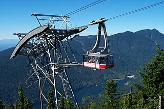
Grouse Mountain is one of the North Shore Mountains of the Pacific Ranges in the District Municipality of North Vancouver, British Columbia, Canada. With a maximum elevation of over 1,200m (4,100ft) at its peak, the mountain is the site of an alpine ski area, Grouse Mountain Resort, which overlooks Metro Vancouver and has four chairlifts servicing 33 runs. In the summer, Grouse Mountain Resort features lumberjack shows, the "Birds in Motion" birds of prey demonstration, a chairlift ride, disc golf, mountain biking, zip lining, tandem paragliding, helicopter tours, and guided ecowalks. Year-round operations include a 100-seat mountaintop theatre and a wildlife refuge. The mountain operates two cable cars, known officially as the Skyride. The Blue Skyride is used mainly for freight transportation, while public access to the mountain top is provided by the Swiss-built Garaventa Red Skyride, which has a maximum capacity of 101 passengers. Summer access is also provided by the 2.9 kilometre Grouse Grind hiking trail, which is open for hiking from May to October. Similar to the nearby Capilano Suspension bridge, Grouse Mountain can be accessed via a free, regular shuttle bus that runs from 'Canada Place' in downtown Vancouver.
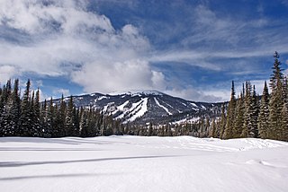
Mount Tod, commonly known as Tod Mountain, is a summit 50 km northeast of Kamloops, British Columbia, Canada. Located northeast of the junction of Louis and McGillivray Creeks, it is part of the upland area between the Interior Plateau (W) and the Monashee Mountains (E) known as the Shuswap Highland, the mountain is the highest of three summits comprising the Sun Peaks alpine ski resort.


