Helena Township is a civil township of Antrim County in the U.S. state of Michigan. The population was 937 at the 2020 census. Helena Township was organized in 1865 by a division of Milton Township. It was named for Helena M. Thayer.

Standish Township is a civil township of Arenac County in the U.S. state of Michigan. The population was 1,701 at the 2020 census. The city of Standish borders the township on the northwest but is administered autonomously.
Bay Mills Township is a civil township of Chippewa County in the U.S. state of Michigan. As of the 2020 census, the township population was 1,567.

Bruce Township is a civil township of Chippewa County in the U.S. state of Michigan. As of the 2020 census, the township population was 2,000.

Chippewa Township is a civil township of Chippewa County in the U.S. state of Michigan. As of the 2020 census, the township population was 187.

Dafter Township is a civil township of Chippewa County in the U.S. state of Michigan. The population was 1,327 at the 2020 census.

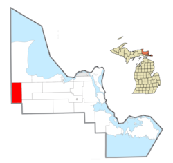
DeTour Township is a civil township of Chippewa County in the U.S. state of Michigan. The population was 671 at the 2020 census. The township is at the extreme eastern tip of the Upper Peninsula.

Rudyard Township is a civil township of Chippewa County in the U.S. state of Michigan. As of the 2020 census, the township population was 1,289. In 2023, Rudyard Township was designated the "Snowy Owl Capital of Michigan".
Nahma Township is a civil township of Delta County in the U.S. state of Michigan. The population was 468 at the 2020 census, slightly down from 495 at the 2010 census. Nahma was established in 1881 by the Bay De Noquet Lumber Company as the base for its upper Michigan lumbering operations.

Bliss Township is a civil township of Emmet County in the U.S. state of Michigan. As of the 2020 census, the township population was 568. It was named after Governor Aaron T. Bliss. Bliss was first platted as allotments for members of the Mackinac Bands of Chippewa and Ottawa Indians in the late 1800s. Bliss Township is the location of Wilderness State Park and White Shoal Light.

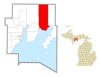
Chippewa Township is a civil township of Isabella County in the U.S. state of Michigan. As of the 2020 census, the township population was 4,446. The city of Mount Pleasant is nearby to the west, and the Mount Pleasant post office, with ZIP code 48858, also serves the northern portion of Chippewa Township.
Deerfield Township is a civil township of Isabella County in the U.S. state of Michigan. The population was 3,257 at the 2020 census.

Newberry is a village and county seat of Luce County in the U.S. state of Michigan. The village is located within McMillan Township and is the only incorporated community in Luce County. The population was 1,446 at the 2020 census.

Barryton is a village in Mecosta County in the U.S. state of Michigan. The population was 405 at the 2020 census, up from 355 in 2010. The village is located in Fork Township on M-66.
Chippewa Township is a civil township of Mecosta County in the U.S. state of Michigan. As of the 2020 census, the township population was 1,227.

Greendale Township is a civil township of Midland County in the U.S. state of Michigan. As of the 2020 census, the township population was 1,731.

Homer Township is a civil township of Midland County in the U.S. state of Michigan. As of the 2020 census, the township population was 3,993.
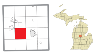
Pierson Township is a civil township of Montcalm County in the U.S. state of Michigan. The population was 3,363 at the 2020 census. The village of Pierson is located within the township.

Chippewa Falls Township is a township in Pope County, Minnesota, United States. The population was 231 at the 2000 census. It includes the unincorporated community of Terrace, Minnesota.
Richland Township is a civil township of Montcalm County in the U.S. state of Michigan. The population was 2,646 at the 2020 census, down from 2,778 in 2010.