Hundar, Leh

Last updated

Hundar
Hunder, Hundur
village

Hundur Gompa, Numbra valley, Ladakh.jpg

India Jammu and Kashmir location map UN view.svg
Red pog.svg
Hundar
Location in Jammu and Kashmir, India
India location map.svg
Red pog.svg
Hundar
Hundar (India)
Coordinates: 34°34′33″N77°29′41″E / 34.575836°N 77.494823°E / 34.575836; 77.494823 Coordinates: 34°34′33″N77°29′41″E / 34.575836°N 77.494823°E / 34.575836; 77.494823
Country India
State Jammu and Kashmir
District Leh
Tehsil Nubra
Population (2011)
  Total 1,179
Time zone IST (UTC+5:30)
Census code 928

Hundar is a village in the Leh district of Jammu and Kashmir, India. [1] It is located in the Nubra tehsil, on the bank of Shyok River. The Hunder Monastery is located here.

Leh district District of Jammu and Kashmir in India

Leh is one of the two districts located in Ladakh, the other being the Kargil District to the west, in the state of Jammu and Kashmir, India. With an area of 45,110 km2, it is the second largest district in the country in terms of area. It is bounded on the north by Ghanche District (Gilgit-Baltistan), a small border with Xinjiang, China, via the Karakoram Pass which is part of the district. Aksai Chin and Tibet are to the east, Kargil district to the west, and Lahul and Spiti to the south. The district headquarters is in Leh. It lies between 32 to 36 degree north latitude and 75 to 80 degree east longitude.

Jammu and Kashmir State in India

Jammu and Kashmir is a state in northern India, often denoted by its acronym, J&K. It is located mostly in the Himalayan mountains, and shares borders with the states of Himachal Pradesh and Punjab to the south. The Line of Control separates it from the Pakistani-administered territories of Azad Kashmir and Gilgit-Baltistan in the west and north respectively, and a Line of Actual Control separates it from the Chinese-administered territory of Aksai Chin in the east. The state has special autonomy under Article 370 of the Constitution of India.

India Country in South Asia

India, also known as the Republic of India, is a country in South Asia. It is the seventh largest country by area and with more than 1.3 billion people, it is the second most populous country as well as the most populous democracy in the world. Bounded by the Indian Ocean on the south, the Arabian Sea on the southwest, and the Bay of Bengal on the southeast, it shares land borders with Pakistan to the west; China, Nepal, and Bhutan to the northeast; and Bangladesh and Myanmar to the east. In the Indian Ocean, India is in the vicinity of Sri Lanka and the Maldives, while its Andaman and Nicobar Islands share a maritime border with Thailand and Indonesia.

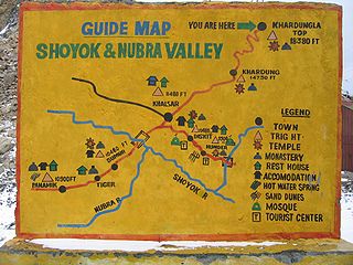
Hundar was once the capital of former Nubra kingdom. There are several ruined buildings, including the ruins of the King's palace, the Langchen Khar ("Elephant Palace"). There is a fort at the top of the hill, called Gula. Hundar also has two Buddhist temples: white temple (Lhakhang Karpo) and the red temple (Lhakhang Marpo). [2] Between Hundar and Diskit lie sand dunes. [3]

Diskit village in Jammu and Kashmir, India

Diskit is a village in the Leh district of Jammu and Kashmir, India. It is located in the Nubra tehsil. The Diskit Monastery is located in this village.

Demographics

According to the 2011 census of India, Hundar has 269 households. The effective literacy rate (i.e. the literacy rate of population excluding children aged 6 and below) is 60.65%. [4]

Demographics (2011 Census) [4]
Total Male Female
Population 1179 548 631
Children aged below 6 years 137 54 83
Scheduled caste 0 0 0
Scheduled tribe 1170 540 630
Literates 632 341 291
Workers (all) 728 341 387
Main workers (total) 267 169 98
Main workers: Cultivators 7 6 1
Main workers: Agricultural labourers 1 1 0
Main workers: Household industry workers 1 1 0
Main workers: Other 258 161 97
Marginal workers (total) 461 172 289
Marginal workers: Cultivators 410 143 267
Marginal workers: Agricultural labourers 23 6 17
Marginal workers: Household industry workers 1 0 1
Marginal workers: Others 27 23 4
Non-workers 451 207 244

Related Research Articles

Tegar village in Jammu and Kashmir, India

Tegar, also known as Tiggar, is a high-altitude village in the Leh district of Jammu and Kashmir, India. It is located in the Nubra tehsil, in the Nubra Valley of Ladakh region.

Hundar Dok village in Jammu and Kashmir, India

Hundar Dok is a village in the Leh district of Jammu and Kashmir, India. It is located in the Nubra tehsil.

Chamshan Charasa village in Jammu and Kashmir, India

Chamshan Charasa is a village in the Leh district of Jammu and Kashmir, India. It is located in the Nubra tehsil.

Partap Pore village in Jammu and Kashmir, India

Partap Pore is a village in the Leh district of Jammu and Kashmir, India. It is located in the Nubra tehsil near Hundar.

Skanpuk village in Jammu and Kashmir, India

Skanpuk is a village in the Leh district of Jammu and Kashmir, India. It is located in the Nubra tehsil.

Chulungkha village in Jammu and Kashmir, India

Chulungkha is a village in the Leh district of Jammu and Kashmir, India. It is located in the Nubra tehsil.

Digger, Leh village in Jammu and Kashmir, India

Digger is a village in the Leh district of Jammu and Kashmir, India. It is located in the Nubra tehsil.

Skuru village in Jammu and Kashmir, India

Skuru is a village in the Leh district of Jammu and Kashmir, India. It is located in the Nubra tehsil.

Bogdang village in Jammu and Kashmir, India

Bogdang is a village in the Leh district of Jammu and Kashmir, India. It is located in the Nubra tehsil.

Warisfistan village in Jammu and Kashmir, India

Warisfistan is a village in the Leh district of Jammu and Kashmir, India. It is located in the Nubra tehsil, on the bank of Nubra River. The Ensa Gompa is located nearby.

Thanga Chathang village in Jammu and Kashmir, India

Thanga Chathang is a village in the Leh district of Jammu and Kashmir, India. It is located in the Nubra tehsil.

Terchey village in Jammu and Kashmir, India

Terchey is a village in the Leh district of Jammu and Kashmir, India. It is located in the Nubra tehsil.

Khalsar, Leh village in Jammu and Kashmir, India

Khalsar is a village in the Leh district of Jammu and Kashmir, India. It is located in the Nubra tehsil.

Khemi village in Jammu and Kashmir, India

Khemi is a village in the Leh district of Jammu and Kashmir, India. It is located in the Nubra tehsil.

Tangyar village in Jammu and Kashmir, India

Tangyar is a village in the Leh district of Jammu and Kashmir, India. It is located in the Nubra tehsil.

Sumoor village in Jammu and Kashmir, India

Sumoor is a village in the Leh district of Jammu and Kashmir, India. It is located in the Nubra tehsil.

Largiab village in Jammu and Kashmir, India

Largiab is a village in the Leh district of Jammu and Kashmir, India. It is located in the Nubra tehsil.

Lakjung village in Jammu and Kashmir, India

Lakjung is a village in the Leh district of Jammu and Kashmir, India. It is located in the Nubra tehsil.

Panamic village in Jammu and Kashmir, India

Panamic is a village in the Leh district of Jammu and Kashmir, India. It is located in the Nubra tehsil.

References

  1. "Blockwise Village Amenity Directory" (PDF). Ladakh Autonomous Hill Development Council. Retrieved 2015-07-23.
  2. Prem Singh Jina (1997). Recent Researches on the Himalaya. Indus. pp. 32–. ISBN   978-81-7387-069-9.
  3. Max Lovell-Hoare; Sophie Lovell-Hoare (1 July 2014). Kashmir: Jammu. Kashmir Valley. Ladakh. Zanskar. Bradt Travel Guides. pp. 113–. ISBN   978-1-84162-396-2.
  4. 1 2 "Leh district census". 2011 Census of India . Directorate of Census Operations. Retrieved 2015-07-23.