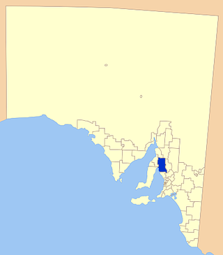
Wakefield Regional Council is a local government area in the Yorke and Mid North region of South Australia. The council seat is at Balaklava.
The District Council of Wakefield Plains was a local government area in South Australia from 1983 to 1997, seated at Balaklava.

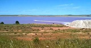
Lochiel is a small town in the Mid North of South Australia 125 km (78 mi) north of Adelaide. The town lies beside on the western edge of Lake Bumbunga and at the eastern foot of the Hummocks Range. The Augusta Highway, a section of Highway 1, runs on a strip between the township and the lake, which dwarfs the former.

Alma is a small town in South Australia halfway between the Wakefield River, to the north, and River Light to the south. Alma, Alma South and Alma Plains were named for the cadastral Hundred of Alma in which they lie, which was in turn named after the Battle of the Alma, the site of an allied victory in the Crimean War.
Everard Central is a locality in South Australia's Mid North. The locality is situated in approximately the southern two thirds of the cadastral Hundred of Everard.
The Hundred of Inkerman is a cadastral unit of hundred located on the northern Adelaide Plains in South Australia and bounded on the north by the Wakefield River. It is one of the eight hundreds of the County of Gawler. It was named in 1856 by Governor Richard MacDonnell after the Crimean War Battle of Inkerman.

The Hundred of Balaklava is a cadastral unit of hundred located on the northern Adelaide Plains in South Australia immediately south of the Wakefield River. It is one of the eight hundreds of the County of Gawler. It was named in 1856 by Governor Dominick Daly after the Crimean War Battle of Balaklava. The township of Balaklava is at the extreme north east corner of the hundred.

The Hundred of Barunga is a cadastral unit of hundred located in the Mid North of South Australia on the approximate area of the Barunga Range, centred on Bald Hill. It is one of the 16 hundreds of the County of Daly. It was named in 1869 by Governor James Fergusson after an indigenous term meaning gap in the range. See Barunga Range § Etymology
The Hundred of Cameron is a cadastral unit of hundred located in the Mid North of South Australia centred on Lake Bumbunga. The northern Hummock Range occupies much of the western half of the area and the Adelaide-Port Augusta railway line runs near and parallel to the eastern boundary. It is one of the 16 hundreds of the County of Daly. It was named in 1869 by Governor James Fergusson for early pioneer Hugh Cameron.

The Hundred of Dalkey is a cadastral unit of hundred located on the northern Adelaide Plains in South Australia immediately south of the Wakefield River. It is one of the eight hundreds of the County of Gawler. It was named in 1856 by Governor Richard Graves MacDonnell for his hometown Dalkey, a seaside resort in Ireland.

The Hundred of Stow is the cadastral unit of hundred on the northern Adelaide Plains. It is one of the 16 hundreds of the County of Stanley. It was named in 1867 by Governor Dominick Daly after Randolph Isham Stow (1828–1878), twice Attorney-General of South Australia. Parts of the localities of Mount Templeton, Stow, Whitwarta, Watchman and Balaklava are within the hundred.
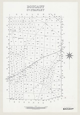
The Hundred of Boucaut is a cadastral unit of hundred located in the Mid North of South Australia. It is one of the 16 hundreds of the County of Stanley. It was named in 1867 by Governor Dominick Daly after parliamentarian James Boucaut.
The District Council of Snowtown was a local government area in South Australia from 1888 to 1987.
The District Council of Blyth-Snowtown was a local government area in South Australia from 1987 until 1997.
The District Council of Hall was a local government area in South Australia from 1878 to 1935.
The Hundred of Hall is the cadastral unit of hundred on the northern Adelaide Plains centred on the town of Halbury. It is one of the 16 hundreds of the County of Stanley. It was named in 1860 after parliamentarian George Hall (1851-1867). The main localities in the hundred are Halbury and Hoyleton with parts of Balaklava, Stow, Watchman and Kybunga also within the hundred bounds.
The District Council of Blyth was a local government area in South Australia from 1872 to 1987 seated at Blyth in the Mid North.

The Hundred of Goyder is the cadastral unit of hundred on the northern Adelaide Plains centred on the locality of Goyder. It is one of the 16 hundreds of the County of Stanley. It was named in 1862 by Governor Dominick Daly after George Goyder, famed South Australian surveyor. In addition to the localities of Goyder and Beaufort, most of Nantawarra lies within the Hundred of Goyder. The portions of Port Wakefield and Bowmans north of the Wakefield River are also inside the hundred, and small parts of the localities of South Hummocks and Mount Templeton cross the western and eastern of boundaries of the hundred, respectively.
The District Council of Port Wakefield was a local government area seated at Port Wakefield in South Australia from 1878 to 1983.
The District Council of Balaklava was a local government area seated at Balaklava in South Australia from 1877 to 1983.

