
Alcona Township is a civil township of Alcona County in the U.S. state of Michigan. The population was 966 at the 2020 census.

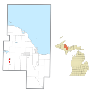
Spurr Township is a civil township of Baraga County in the U.S. state of Michigan. The population was 262 at the 2020 census.

Portage Charter Township is a charter township of Houghton County in the U.S. state of Michigan. As of the 2010 census, the township population was 3,221. The city of Houghton is adjacent to the north side of the township. Portage Lake is the eastern boundary in the north, and the township extends well south of Houghton to the Baraga County line.
Au Sable is an unincorporated community and census-designated place (CDP) in the U.S. state of Michigan. The population of the CDP was 1,453 at the 2020 census. The community is located within Au Sable Township at the mouth of the Au Sable River along Lake Huron.

Allouez Township is a civil township of Keweenaw County in the U.S. state of Michigan. The population was 1,428 at the 2020 census.

Gwinn is an unincorporated community in Marquette County in the U.S. state of Michigan. It is a census-designated place (CDP) for statistical purposes and has no legal status as an incorporated municipality. The population of the CDP was 1,784 at the 2020 census. The community is located within Forsyth Township.
Republic is an unincorporated community in Marquette County in the U.S. state of Michigan. It is also a census-designated place (CDP) for statistical purposes and no legal status as an incorporated municipality. The CDP had a population of 470 at the 2020 census, down from 570 in 2010. The community is located mostly within Republic Township with a small portion extending north into Humboldt Township.
Dodgeville is an unincorporated community and census-designated place (CDP) in Houghton County in the U.S. state of Michigan. The CDP had a population of 391 at the 2020 census. Dodgeville is located in Michigan's Upper Peninsula and is located just south of the city of Houghton.
Amasa is an unincorporated community and census-designated place (CDP) in Iron County in the U.S. state of Michigan. The population of the CDP was 195 at the 2020 census. The community is located within Hematite Township.
Atlantic Mine is an unincorporated community and census-designated place (CDP) in Houghton County in the U.S. state of Michigan. The CDP had a population of 565 at the 2020 census. The community is located just southwest of the city of Houghton in Adams Township. Atlantic Mine is located in the Copper Country region of Michigan's Upper Peninsula. The community is named for the eponymous Atlantic Mine.

Bay Port is an unincorporated community and census-designated place (CDP) in Huron County in the U.S. state of Michigan. The population was 477 at the 2010 census. As an unincorporated community, Bay Port has no legal autonomy of its own but does have its own post office with the 48720 ZIP Code.

Dollar Bay is a census-designated place (CDP) in Houghton County, Michigan, United States. The population was 1,082 at the 2010 census.

Brimley is an unincorporated community and census-designated place (CDP) in Chippewa County in the U.S. state of Michigan. The CDP had a population of 504 at the 2020 census. Brimley is located in Michigan's Upper Peninsula, and is located along the southern shore of Lake Superior. The community is located within Superior Township.

Eagle River is an unincorporated community and census-designated place (CDP) in the U.S. state of Michigan. It is the county seat of Keweenaw County. Its population was 65 at the 2020 census, which makes it by far the least-populated county seat in the state of Michigan. As an unincorporated community, Eagle River has no legal autonomy and is part of Allouez Township and Houghton Township.

Three Lakes is an unincorporated community and census-designated place (CDP) in Baraga County in the U.S. state of Michigan. The CDP had a population of 167 at the 2020 census. Three Lakes is located within Spurr Township.

Skanee is an unincorporated community and census-designated place (CDP) in Baraga County in the U.S. state of Michigan. The CDP had a population of 102 at the 2020 census. Skanee is located in Arvon Township on the shore of Huron Bay, a bay of Lake Superior.

Chassell is an unincorporated community and census-designated place (CDP) in Houghton County in the U.S. state of Michigan. The CDP had a population of 876 at the 2020 census. Chassell is located within Chassell Township, and is located on the shore of Portage Lake in the Upper Peninsula. As an unincorporated community, Chassell has no legal autonomy of its own, however it does have a post office with the ZIP code 49916.

Ponshewaing is an unincorporated community and census-designated place (CDP) in Emmet County in the U.S. state of Michigan. As of the 2010 census, the CDP had a population of 69. It is located within Littlefield Township.
Fulton is an unincorporated community and census-designated place (CDP) in Keweenaw County in the U.S. state of Michigan. The CDP had a population of 149 at the 2020 census. The community is located in Allouez Township, immediately southeast of the community of Mohawk. Fulton is located in the Copper Country region of Michigan's Upper Peninsula.

Presque Isle Harbor is an unincorporated community and census-designated place (CDP) in Presque Isle County in the U.S. state of Michigan. Its population was 600 as of the 2010 census. The CDP is located along the shores of Lake Huron within Presque Isle Township.


