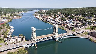
Houghton is the largest city and seat of government of Houghton County in the U.S. state of Michigan. Located on the Keweenaw Peninsula, Houghton is the largest city in the Copper Country region. It is the fifth-largest city in the Upper Peninsula, with a population of 8,386 at the 2020 census. Houghton is the principal city of the Houghton micropolitan area, which includes all of Houghton and Keweenaw counties. Houghton lies upon the Keweenaw Waterway, a partly natural, partly artificial waterway connecting at both ends to Lake Superior. Across the waterway from Houghton lies the city of Hancock.

Hancock is a city in Houghton County in the U.S. state of Michigan. It is across the Keweenaw Waterway from the city of Houghton on the Keweenaw Peninsula. The population was 4,634 at the 2010 census. The Weather Channel has consistently ranked Hancock as the third-snowiest city in the U.S.

Wayne County is the most populous county in the U.S. state of Michigan. As of 2020, the United States Census placed its population at 1,793,561, making it the 19th-most populous county in the United States. The county seat is Detroit. The county was founded in 1796 and organized in 1815. Wayne County is included in the Detroit-Warren-Dearborn, MI Metropolitan Statistical Area. It is one of several U.S. counties named after Revolutionary War-era general Anthony Wayne.

Macomb County is a county located in the eastern portion of the U.S. state of Michigan, bordering Lake St. Clair, and is part of northern Metro Detroit. As of the 2020 Census, the population was 881,217, making it the third-most populous county in the state. The county seat is Mt. Clemens. Macomb County is part of the Detroit-Warren-Dearborn, MI Metropolitan Statistical Area. The city of Detroit is located south of the county's southern border. Macomb County contains 27 cities, townships and villages, including three of the top ten most-populous municipalities in Michigan as of the 2010 census: Warren (#3), Sterling Heights (#4) and Clinton Township (#10). Most of this population is concentrated south of Hall Road (M-59), one of the county's main thoroughfares.

Houghton County is a county in the Upper Peninsula in the U.S. state of Michigan. As of the 2020 Census, the population was 37,361. The county seat and largest city is Houghton. Both the county and the city were named for Michigan State geologist and Detroit Mayor Douglass Houghton.

Calumet Charter Township is a charter township of Houghton County in the U.S. state of Michigan. The population was 6,263 at the 2020 census. Even with a decreasing population, the township remains the largest township by population in Houghton County.

Portage Charter Township is a charter township of Houghton County in the U.S. state of Michigan. As of the 2010 census, the township population was 3,221. The city of Houghton is adjacent to the north side of the township. Portage Lake is the eastern boundary in the north, and the township extends well south of Houghton to the Baraga County line.

Ypsilanti Charter Township is a charter township of Washtenaw County in the U.S. state of Michigan. The population was 53,362 at the 2010 census. The city of Ypsilanti is mostly surrounded by the township, but the two are administered autonomously.

Scarborough is a district of Toronto, Ontario, Canada. It is situated atop the Scarborough Bluffs in the eastern part of the city. Its borders are Victoria Park Avenue to the west, Steeles Avenue and the city of Markham to the north, Rouge River and the city of Pickering to the east, and Lake Ontario to the south. Scarborough was named after the English town of Scarborough, North Yorkshire, inspired by its cliffs.

Whitchurch-Stouffville is a town in the Greater Toronto Area of Ontario, Canada, approximately 50 km (31 mi) north of downtown Toronto, and 55 km (34 mi) north-east of Toronto Pearson International Airport. It is 206.22 km2 (79.62 sq mi) in area, and located in the mid-eastern area of the Regional Municipality of York on the ecologically-sensitive Oak Ridges Moraine. Its motto since 1993 is "country close to the city".

The Cleveland metropolitan area, or Greater Cleveland as it is more commonly known, is the metropolitan area surrounding the city of Cleveland in Northeast Ohio, United States. According to the 2020 United States Census results, the five-county Cleveland–Elyria Metropolitan Statistical Area (MSA) consists of Cuyahoga County, Geauga County, Lake County, Lorain County, and Medina County, and has a population of 2,088,251, making it the 34th most populous metropolitan area in the United States, and the third largest metropolitan area in Ohio. The metro area is also part of the larger Cleveland–Akron–Canton Combined Statistical Area with a population of over 3.6 million people, the most populous statistical area in Ohio and the 17th most populous in the United States.

M-26 is a 96.355-mile-long (155.068 km) state trunkline highway in the U.S. state of Michigan, running from two miles (3.2 km) east of Rockland to its junction with US Highway 41 (US 41) in Copper Harbor. It generally runs southwest-to-northeast in the western half or Michigan's Upper Peninsula. The northernmost segment, which closely parallels the shore of Lake Superior on the west side of the Keweenaw Peninsula, is highly scenic.
Stouffville is the primary urban area within the town of Whitchurch-Stouffville in York Region, Ontario, Canada. It is situated within the Greater Toronto Area and the inner ring of the Golden Horseshoe. The urban area is centred at the intersection of Main Street, Mill Street, and Market Street. Between 2006 and 2011, the population of the Community of Stouffville grew 100.5% from 12,411 to 24,886, or from 51% to 66% of the total population of the larger town of Whitchurch-Stouffville.

The Huron River is a 130-mile-long (210 km) river in southeastern Michigan, rising out of the Huron Swamp in Springfield Township in northern Oakland County and flowing into Lake Erie, as it forms the boundary between present-day Wayne and Monroe counties. Thirteen parks, game areas, and recreation areas are associated with the river, which passes through the cities of Dexter, Ann Arbor, Ypsilanti, Belleville, Flat Rock and Rockwood that were developed along its banks.
King City is an unincorporated Canadian community in the township of King, Ontario, located north of Toronto. It is the largest community in King township, with 2,730 dwellings and a population of 8,396 as of the 2021 Canadian census.

Hurontario Street is a roadway running in Ontario, Canada between Lake Ontario at Mississauga and Lake Huron's Georgian Bay at Collingwood. Within Peel Region, it is a major urban thoroughfare within the cities of Mississauga and Brampton, which serves as the divide from which cross-streets are split into East and West, except at its foot in the historic Mississauga neighbourhood of Port Credit. Farther north, with the exception of the section through Simcoe County, where it forms the 8th Concession, it is the meridian for the rural municipalities it passes through. In Dufferin County, for instance, parallel roads are labelled as EHS or WHS for East of Hurontario Street.
Pine Creek is a tributary of Mahantango Creek in Schuylkill and Dauphin counties, Pennsylvania, in the United States. It is approximately 23.7 miles (38.1 km) long. The creek flows through Foster Township, Hegins Township, Hubley Township, and Upper Mahantango Township in Schuylkill County and Lykens Township in Dauphin County. The creek's watershed has an area of 76.8 square miles (199 km2) and its tributaries include Rausch Creek and Deep Creek. Pine Creek is considered by the Pennsylvania Department of Environmental Protection to be impaired by abandoned mine drainage and resource extraction. However, it is designated as a coldwater fishery.

US Highway 41 (US 41) is a part of the United States Numbered Highway System that runs from Miami, Florida, to the Upper Peninsula of the US state of Michigan. In Michigan, it is a state trunkline highway that enters the state via the Interstate Bridge between Marinette, Wisconsin, and Menominee, Michigan. The 278.769 miles (448.635 km) of US 41 that lie within Michigan serve as a major conduit. Most of the highway is listed on the National Highway System. Various sections are rural two-lane highway, urbanized four-lane divided expressway and the Copper Country Trail National Scenic Byway. The northernmost community along the highway is Copper Harbor at the tip of the Keweenaw Peninsula. The trunkline ends at a cul-de-sac east of Fort Wilkins State Park after serving the Central Upper Peninsula and Copper Country regions of Michigan.

The Akron, OH Metropolitan Statistical Area, sometimes referred to as Greater Akron, is defined by the United States Office of Management and Budget as an area consisting of two counties, Summit and Portage, in Northeast Ohio and anchored by the city of Akron. As of the 2020 census, the MSA had a population of 702,219. The Akron MSA is also part of the larger Cleveland–Akron–Canton, OH Combined Statistical Area, which has a population of 3,633,962 people as of the 2020 census, the largest metropolitan area in Ohio.

