Torch Lake Township, Houghton County, Michigan

Last updated

Torch Lake Township, Michigan
Torch Lake Township (Houghton), MI location2.png
Location within Houghton County (red) with the administered portion of the Hubbell community (pink)
USA Michigan location map.svg
Red pog.svg
Torch Lake Township
Location within the state of Michigan
Usa edcp location map.svg
Red pog.svg
Torch Lake Township
Torch Lake Township (the United States)
Coordinates: 47°07′42″N88°24′09″W / 47.12833°N 88.40250°W / 47.12833; -88.40250
Country United States
State Michigan
County Houghton
Established1886
Government
  SupervisorBrian Cadwell
Area
  Total93.0 sq mi (240.9 km2)
  Land80.1 sq mi (207.6 km2)
  Water12.9 sq mi (33.3 km2)
Elevation
741 ft (226 m)
Population
 (2000)
  Total1,860
  Density23.2/sq mi (9.0/km2)
Time zone UTC-5 (Eastern (EST))
  Summer (DST) UTC-4 (EDT)
ZIP code(s)
49922 (Dollar Bay)
49934 (Hubbell)
49945 (Lake Linden)
Area code 906
FIPS code 26-80120 [1]
GNIS feature ID1627170 [2]
Website Official website

Torch Lake Township is a civil township of Houghton County in the U.S. state of Michigan. As of the 2010 census, the population of the township was 1,880. [3] The township was established in 1886 and is one of the largest townships in Houghton County by area. It is surrounded by the Torch Lake, the Portage Lake, and Lake Superior. As well as a large number of unincorporated communities, the township also includes a portion of the Baraga State Forest which lies along the shores of Keweenaw Bay. The township borders Schoolcraft Township to the north, Osceola Township to the northwest, and Chassell Township to the southwest. [4] [5] [3] The community of Hubbell serves as the major population center of the township, as well as hosting the Township Hall itself. [6] [4] The mostly uninhabited 91-acre Rabbit Island, located offshore in Lake Superior, is a part of the township. [7]

Contents

Communities

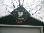
The sign for Chickensville Location Chickenville.jpg
The sign for Chickensville Location

Geography

According to the United States Census Bureau, the township has a total area of 93.0 square miles (240.9 km2), of which 80.1 square miles (207.6 km2) is land and 12.9 square miles (33.3 km2) (13.83%) is water.

Attractions

Climate

Jacobsville is a community in the Torch Lake Township. [16] Jacobsville has a humid continental climate (Köppen Dfb) with warm summers and cold, snowy winters.

Climate data for Jacobsville, Michigan, 1991–2020 normals: 650ft (198m)
MonthJanFebMarAprMayJunJulAugSepOctNovDecYear
Record high °F (°C)49
(9)
61
(16)
79
(26)
76
(24)
90
(32)
92
(33)
92
(33)
93
(34)
90
(32)
87
(31)
77
(25)
55
(13)
93
(34)
Mean maximum °F (°C)42.4
(5.8)
43.6
(6.4)
57.7
(14.3)
67.5
(19.7)
82.8
(28.2)
86.7
(30.4)
89.2
(31.8)
88.0
(31.1)
83.8
(28.8)
74.8
(23.8)
58.4
(14.7)
45.2
(7.3)
90.5
(32.5)
Mean daily maximum °F (°C)23.5
(−4.7)
25.4
(−3.7)
34.3
(1.3)
46.4
(8.0)
59.9
(15.5)
70.1
(21.2)
76.7
(24.8)
75.2
(24.0)
67.4
(19.7)
53.0
(11.7)
39.5
(4.2)
28.5
(−1.9)
50.0
(10.0)
Daily mean °F (°C)16.3
(−8.7)
17.0
(−8.3)
23.8
(−4.6)
36.5
(2.5)
47.9
(8.8)
57.4
(14.1)
63.8
(17.7)
62.8
(17.1)
55.7
(13.2)
43.8
(6.6)
32.4
(0.2)
22.0
(−5.6)
39.9
(4.4)
Mean daily minimum °F (°C)9.1
(−12.7)
8.5
(−13.1)
13.2
(−10.4)
26.5
(−3.1)
35.9
(2.2)
44.7
(7.1)
50.8
(10.4)
50.4
(10.2)
44.0
(6.7)
34.6
(1.4)
25.4
(−3.7)
15.5
(−9.2)
29.9
(−1.2)
Mean minimum °F (°C)−8.5
(−22.5)
−12.6
(−24.8)
−9.7
(−23.2)
11.6
(−11.3)
25.6
(−3.6)
32.4
(0.2)
40.6
(4.8)
40.0
(4.4)
31.1
(−0.5)
24.1
(−4.4)
9.4
(−12.6)
−2.2
(−19.0)
−14.3
(−25.7)
Record low °F (°C)−18
(−28)
−26
(−32)
−23
(−31)
−1
(−18)
22
(−6)
26
(−3)
36
(2)
35
(2)
28
(−2)
20
(−7)
−1
(−18)
−14
(−26)
−26
(−32)
Average precipitation inches (mm)1.97
(50)
1.40
(36)
1.46
(37)
2.86
(73)
3.37
(86)
3.26
(83)
3.23
(82)
2.80
(71)
3.49
(89)
2.99
(76)
2.40
(61)
2.40
(61)
31.63
(805)
Average snowfall inches (cm)29.3
(74)
19.8
(50)
10.3
(26)
11.6
(29)
0.2
(0.51)
0.0
(0.0)
0.0
(0.0)
0.0
(0.0)
trace1.4
(3.6)
14.1
(36)
27.0
(69)
113.7
(288.11)
Source 1: NOAA [17]
Source 2: XMACIS (2010-2020 snowfall, records & monthly max/mins) [18]

Demographics

As of the census [1] of 2000, there were 1,860 people, 740 households, and 523 families residing in the township. The population density was 23.2 per square mile (9.0/km2). There were 1,505 housing units at an average density of 18.8 per square mile (7.3/km2). The racial makeup of the township was 98.98% White, 0.43% African American, 0.11% Native American, 0.05% Asian, 0.05% from other races, and 0.38% from two or more races. Hispanic or Latino of any race were 0.32% of the population. 28.3% were of Finnish, 17.0% French, 12.6% German, 7.7% Italian, 6.9% English and 6.9% French Canadian ancestry according to Census 2000.

There were 740 households, out of which 26.6% had children under the age of 18 living with them, 59.9% were married couples living together, 6.6% had a female householder with no husband present, and 29.3% were non-families. 25.9% of all households were made up of individuals, and 11.9% had someone living alone who was 65 years of age or older. The average household size was 2.40 and the average family size was 2.86.

In the township the population was spread out, with 22.4% under the age of 18, 5.3% from 18 to 24, 23.0% from 25 to 44, 28.1% from 45 to 64, and 21.2% who were 65 years of age or older. The median age was 44 years. For every 100 females, there were 96.2 males. For every 100 females age 18 and over, there were 95.5 males.

The median income for a household in the township was $35,893, and the median income for a family was $43,077. Males had a median income of $31,307 versus $25,208 for females. The per capita income for the township was $19,158. About 6.9% of families and 9.8% of the population were below the poverty line, including 15.3% of those under age 18 and 9.8% of those age 65 or over.

Related Research Articles

<span class="mw-page-title-main">Houghton, Michigan</span> City in Michigan, United States

Houghton is the largest city and county seat of Houghton County in the U.S. state of Michigan. Located on the Keweenaw Peninsula, Houghton is the largest city in the Copper Country region. It is the fifth-largest city in the Upper Peninsula, with a population of 8,386 at the 2020 census. Houghton is the principal city of the Houghton micropolitan area, which includes all of Houghton and Keweenaw counties. Houghton lies upon the Keweenaw Waterway, a partly natural, partly artificial waterway connecting at both ends to Lake Superior. Across the waterway from Houghton lies the city of Hancock.

Dreamland is an unincorporated community on Copper Island, in Torch Lake Township, Houghton County, in the Upper Peninsula of the U.S. state of Michigan. It has been described as being a "district of Bootjack" or in Bootjack, but it is a separate town. The town consists almost entirely of the Dreamland Inn and some docks on Torch Bay.

<span class="mw-page-title-main">Hancock, Michigan</span> City in Michigan, United States

Hancock is a city in the Upper Peninsula of the U.S. state of Michigan. The population of Hancock was 4,501 at the 2020 census. The city is located within Houghton County, and is situated upon the Keweenaw Waterway, a channel of Lake Superior that cuts across the Keweenaw Peninsula. Hancock is located across the Keweenaw Waterway from the city of Houghton, and is connected to that city by the Portage Lake Lift Bridge. The city is located within Michigan's Copper Country region.

<span class="mw-page-title-main">Keweenaw County, Michigan</span> County in Michigan, United States

Keweenaw County is a county in the western Upper Peninsula of the U.S. state of Michigan. As of the 2020 census, the county's population was 2,046, making it Michigan's least populous county. It is also the state's largest county by total area, including the waters of Lake Superior, as well as the state's northernmost county. The county seat is Eagle River.

<span class="mw-page-title-main">Houghton County, Michigan</span> County in Michigan, United States

Houghton County is a county in the Upper Peninsula in the U.S. state of Michigan. As of the 2020 census, the population was 37,361. The county seat and largest city is Houghton. Both the county and the city were named for Michigan State geologist and Detroit Mayor Douglass Houghton.

<span class="mw-page-title-main">Calumet, Michigan</span> Village in Michigan, United States

Calumet is a village in the Upper Peninsula of the U.S. state of Michigan. The village is located within Calumet Township, Houghton County, and had a population of 621 at the 2020 census.

<span class="mw-page-title-main">L'Anse Township, Michigan</span> Civil township in Michigan, United States

L'Anse Township is a civil township of Baraga County in the U.S. state of Michigan. As of the 2020 census, the township population was 3,551. The township contains Mount Arvon and Mount Curwood, Michigans highest and second-highest points, as well as the village of L'Anse.

<span class="mw-page-title-main">Adams Township, Houghton County, Michigan</span> Civil township in Michigan, United States

Adams Township is a civil township of Houghton County in the U.S. state of Michigan. As of the 2020 census, the township population was 2,540.

<span class="mw-page-title-main">Calumet Charter Township, Michigan</span> Charter township in Michigan, United States

Calumet Township, officially the Charter Township of Calumet, is a charter township of Houghton County in the Upper Peninsula of the U.S. state of Michigan. The population was 6,263 at the 2020 census. Even with a decreasing population, the township remains the largest township by population in Houghton County.

<span class="mw-page-title-main">Hubbell, Michigan</span> Census-designated place & unincorporated community in Michigan, United States

Hubbell is an unincorporated community and census-designated place (CDP) in Houghton County in the U.S. state of Michigan. As of the 2010 census, the CDP population was 946, down from 1,105 at the 2000 census. The community is partially within Torch Lake Township and partially within Osceola Township.

<span class="mw-page-title-main">Allouez Township, Michigan</span> Civil township in Michigan, United States

Allouez Township is a civil township of Keweenaw County in the U.S. state of Michigan. The population was 1,428 at the 2020 census.

<span class="mw-page-title-main">Eagle Harbor Township, Michigan</span> Civil township in Michigan, United States

Eagle Harbor Township is a civil township of Keweenaw County in the U.S. state of Michigan. The population was 217 at the 2020 census. The township is located on the Keweenaw Peninsula and also includes the southwestern portion of Isle Royale National Park.

<span class="mw-page-title-main">Grant Township, Keweenaw County, Michigan</span> Civil township in Michigan, United States

Grant Township is a civil township of Keweenaw County in the U.S. state of Michigan. The population was 275 at the 2020 census. Grant Township is one of the most isolated municipalities in Michigan, as it forms the tip of the Keweenaw Peninsula, which projects into Lake Superior.

<span class="mw-page-title-main">Houghton Township, Michigan</span> Civil township in Michigan, United States

Houghton Township is a civil township of Keweenaw County in the U.S. state of Michigan. The population was 72 at the 2020 census.

<span class="mw-page-title-main">Sherman Township, Keweenaw County, Michigan</span> Civil township in Michigan, United States

Sherman Township is a civil township of Keweenaw County in the U.S. state of Michigan. The population was 91 at the 2020 census.

Torch Bay is a freshwater bay connecting Torch Lake with Portage Lake in Houghton County on the Keweenaw Peninsula, which juts into Lake Superior from the Upper Peninsula of Michigan. It is lined by the unincorporated settlements of Dreamland, Point Mills and Senter and by wooded hills of as much as 200 feet in height.


<span class="mw-page-title-main">Keweenaw Waterway</span> Canal across the Keweenaw Peninsula, Michigan

The Keweenaw Waterway is a partly natural, partly artificial waterway which cuts across the Keweenaw Peninsula of Michigan; it separates Copper Island from the mainland. Parts of the waterway are variously known as the Keweenaw Waterway, Portage Canal, Portage Lake Canal, Portage River, Lily Pond, Torch Lake, and Portage Lake. The waterway connects to Lake Superior at its north and south entries, with sections known as Portage Lake and Torch Lake in between. The primary tributary to Portage Lake is the Sturgeon River.

<span class="mw-page-title-main">Eagle River, Michigan</span> Census-designated place & unincorporated community in Michigan, United States

Eagle River is an unincorporated community and census-designated place (CDP) in the U.S. state of Michigan. It is the county seat of Keweenaw County. Its population was 65 at the 2020 census, which makes it by far the least-populated county seat in the state of Michigan. As an unincorporated community, Eagle River has no legal autonomy and is part of Allouez Township and Houghton Township.

<span class="mw-page-title-main">Houghton micropolitan area, Michigan</span> Micropolitan area in Upper Michigan

The Houghton Micropolitan Statistical Area, as defined by the United States Census Bureau, is an area consisting of two counties in the Upper Peninsula of Michigan, specifically the Keweenaw Peninsula, anchored by the city of Houghton.

Clarence J. Monette was a prolific author and historian from Michigan's Copper Country, writing extensively on Copper Country history. He has published more than sixty books and has written numerous outdoor survival guides.

References

  1. 1 2 "U.S. Census website". United States Census Bureau . Retrieved January 31, 2008.
  2. U.S. Geological Survey Geographic Names Information System: Torch Lake Township, Houghton County, Michigan
  3. 1 2 "Houghton County Master Plan" (PDF). Houghton County Planning Commission. 2012. Archived (PDF) from the original on September 14, 2012.
  4. 1 2 3 4 5 6 7 8 9 10 "Torch Lake Township 2014-2018 Recreation Plan" (PDF). Western Upper Peninsula Planning & Development Region. 2014. Archived (PDF) from the original on May 8, 2019. Retrieved May 7, 2019.
  5. 1 2 3 4 5 6 7 8 9 10 11 12 13 14 Monette, Clarence (1975). Some Copper Country Names and Places. Lake Linden, Michigan. ISBN   0-942363-04-3.{{cite book}}: CS1 maint: location missing publisher (link)
  6. 1 2 "Torch Lake Twp., Houghton Co". www.michigantownships.org. Retrieved May 8, 2019.
  7. "Rabbit Island". Foursquare. Retrieved May 8, 2019.
  8. 1 2 3 4 5 6 7 8 9 10 11 Molloy, Lawrence J. (2011). A Guide to Michigan's Historic Keweenaw Copper District: Photographs, Maps, and Tours of the Keweenaw—Past and Present. Great Lakes GeoScience. ISBN   978-0-979-1772-1-7.
  9. Monette, Clarence J. (1976). The History of Jacobsville and its Sandstone Quarries. Lake Linden, Michigan.{{cite book}}: CS1 maint: location missing publisher (link)
  10. Eckert, Kathryn Bishop (2000). The sandstone architecture of the Lake Superior region. Wayne State University Press. p. 31. ISBN   0814328075 . Retrieved July 17, 2011.
  11. 1 2 Romig, Walter (1973). Michigan place names. Wayne State University Press. p. 290. ISBN   978-0-8143-1838-6 . Retrieved December 15, 2011.
  12. "About the Rabbit Island Foundation". Tumblr. Retrieved May 8, 2019.
  13. "Jacobsville Chapel – Gloria Dei Lutheran Church" . Retrieved May 8, 2019.
  14. "Finnish Lutheran Church / Jacobsville - MichMarkers". www.michmarkers.com. Retrieved May 8, 2019.
  15. "Keweenaw Waterway Lower Entrance Light". www.nps.gov. Retrieved May 8, 2019.
  16. "Jacobsville (in Houghton County, MI) Populated Place Profile". HomeTownLocator. Retrieved December 20, 2023.
  17. "Jacobsville, Michigan 1991-2020 Monthly Normals" . Retrieved December 20, 2023.
  18. "xmACIS". National Oceanic and Atmospheric Administration. Retrieved December 20, 2023.