
The 1996 Pacific hurricane season is tied with 2021 for the most Pacific hurricanes to make landfall on Mexico in one year, with four striking the country. It was a below average season that produced 9 tropical storms, 5 hurricanes and 2 major hurricanes. With 9 tropical storms, 1996 ranks as the second-least active Pacific hurricane season on record. It officially began May 15, 1996, in the eastern north Pacific and on June 1, 1996, in the central north Pacific. It ended on November 30, 1996. These dates conventionally delimit the period of each year when most tropical cyclones form in the northeastern Pacific Ocean. The season slightly exceeded these bounds when tropical storm One-E formed on May 13.

The 1990 Pacific hurricane season was a very active season which observed 21 named storms within the basin. The season also produced the fourth highest ACE index value on record. The season was officially started on May 15 in the eastern Pacific, and on June 1 in the central Pacific, and lasted until November 30. These dates conventionally delimit the period of each year when most tropical cyclones form in the northeastern Pacific Ocean. However, the formation of tropical cyclones is possible at any time of the year, as illustrated in 1990 by the formation of the season's first named storm, Hurricane Alma, on May 12. At the time, this was the earliest formation of a tropical storm on record in the eastern Pacific

Hurricane Calvin was one of three Pacific hurricanes on record to make landfall along the Mexican coast during the month of July. The fourth tropical cyclone, third named storm, and second hurricane of the 1993 Pacific hurricane season, Calvin developed from an area of convection to the south of Mexico on July 4. The following day, the system intensified into a tropical storm, which was named Calvin. Continued strengthening ensued as Calvin curved from its initial westward track northward, and was upgraded to a hurricane on July 6 Calvin eventually turned northwest, and became a Category 2 hurricane on the Saffir–Simpson hurricane wind scale (SSHWS). By July 7, Hurricane Calvin made landfall near Manzanillo at peak strength. Calvin rapidly weakened after landfall, and was a tropical storm when it reemerged into the Pacific Ocean on early on July 8. Despite this, the hurricane did not reintensify, and continued to weaken as it headed rapidly northwestward. As Calvin made a second Mexican landfall near the southern tip of Baja California peninsula late on July 8, it weakened to a tropical depression. Early on July 9, the depression dissipated shortly after entering the Pacific Ocean for a third time.

The 2008 Pacific hurricane season was a near-average Pacific hurricane season which featured seventeen named storms, though most were rather weak and short-lived. Only seven hurricanes formed and two major hurricanes. This season was also the first since 1996 to have no cyclones cross into the central Pacific. The season officially began on May 15 in the eastern Pacific and on June 1 in the central Pacific. It ended in both regions on November 30. These dates, adopted by convention, historically describe the period in each year when most tropical cyclone formation occurs in these regions of the Pacific. This season, the first system, Tropical Storm Alma, formed on May 29, and the last, Tropical Storm Polo, dissipated on November 5.

Hurricane Rick was the second-latest hurricane ever to make landfall in Mexico. The eighteenth named storm, ninth and final hurricane of the 1997 Pacific hurricane season, Rick was a short-lived Category 2 hurricane on the Saffir-Simpson Hurricane Scale that weakened before making landfall in Mexico on November 10. It hit almost a month after the more powerful Hurricane Pauline made landfall in the same country. Most of the damage associated with Pauline was exacerbated by the weaker Rick, which struck during rebuilding efforts.

Hurricane Naomi was a short-lived Category 1 hurricane that made landfall in Mexico's Pacific coast during the 1968 Pacific hurricane season. After rapidly intensifying before its landfall in Sinaloa, Naomi caused rainfall throughout northern Mexico and the U.S. state of Texas in association with a frontal system, with the highest measurement occurring in Corpus Christi. Four people perished in Mexico due to Naomi's effects with ten more missing, all in Sinaloa. The only reported injury in Texas due to the remnants was a factory worker who was injured when the roof of the plant they were working in collapsed due to rainfall.
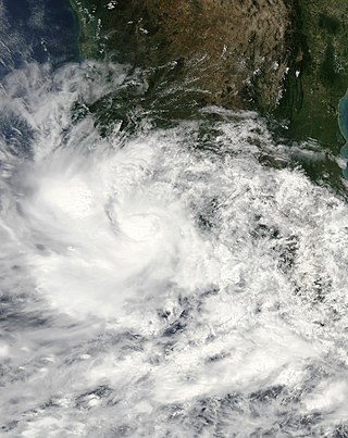
Tropical Storm Alma of the 2008 Pacific hurricane season was the easternmost forming Pacific tropical cyclone on record. It formed within the monsoon trough just off the coast of Costa Rica on May 29. Initially forecast to remain a weak tropical storm, the cyclone rapidly strengthened and developed an eye, before making landfall on May 29 in Nicaragua, near León, with peak winds of 65 mph (105 km/h). Alma degenerated into a remnant low on May 30, before merging with another approaching tropical wave in the Gulf of Honduras shortly afterward, which became Tropical Storm Arthur on the next day. Alma was the first tropical storm on record to strike the Pacific coast of Nicaragua. In Costa Rica, heavy rainfall caused flooding and landslides, killing two and causing $35 million (USD) in damage. Three people were killed in Nicaragua, one from drowning and two others from electrocution. Five others died in Honduras from an aviation accident likely related to the storm and one other was swept away in floodwaters.

Tropical Storm Norman was a weak tropical cyclone that brought heavy rainfall to southwestern Mexico in October 2006. The fifteenth named storm of the 2006 Pacific hurricane season, Norman developed on October 9 from a tropical wave well to the southwest of Mexico. Unfavorable conditions quickly encountered the system, and within two days of forming, Norman dissipated as its remnants turned to the east. Thunderstorms gradually increased again, as it interacted with a disturbance to its east, and on October 15 the cyclone regenerated just off the coast of Mexico. The center became disorganized and quickly dissipated, bringing a large area of moisture which dropped up to 6 inches (150 mm) of rainfall to southwestern Mexico. Rainfall from the storm flooded about 150 houses, of which 20 were destroyed. One person was injured, and initially there were reports of two people missing due to the storm; however, it was not later confirmed.

Tropical Storm Kiko was a strong tropical storm that capsized a boat off the western coast of Mexico, killing at least 15 people. The 15th and final tropical cyclone of the 2007 Pacific hurricane season, Kiko developed out of a tropical wave that formed off the coast of Africa on September 26 and traversed the Atlantic. The wave crossed over Central America and entered the Pacific Ocean on October 8, where it spawned Tropical Depression 15-E on October 15. The depression drifted to the south over the next day before briefly being declared Tropical Storm Kiko. It subsequently weakened into a tropical depression, but later reattained tropical storm intensity. By October 18, Kiko was forecast to make landfall along the western Mexican coastline as a moderate tropical storm. However, the cyclone turned to the west and reached its peak intensity of 70 mph (110 km/h) on October 20. The tropical storm slowly weakened to a remnant low-pressure area by October 24 and completely dissipated on October 27 without making landfall.

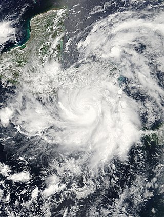
Hurricane Boris was the second of three storms to impact the Pacific coast of Mexico in June and July 1996. The fourth tropical cyclone and second hurricane of the 1996 Pacific hurricane season, Boris formed out of a tropical wave roughly 250 mi (400 km) south of the Gulf of Tehuantepec on June 27. The storm gradually intensified, becoming a tropical storm the following day and then hurricane on June 29. As the storm neared landfall, an eye developed and Boris reached its peak intensity with winds of 90 mph (140 km/h). Shortly after, the hurricane made landfall along the south coast of Mexico, between Lazaro Cardenas and Acapulco, at this intensity. Boris quickly weakened following its landfall, becoming a tropical depression roughly 18 hours later. The remnants of the system persisted until July 1, at which time it dissipated just offshore the Mexican coastline. Boris caused heavy flooding in southern Mexico that resulted in ten fatalities; however, a damage estimate is unknown.

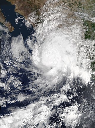
Hurricane Hernan was fourth and final tropical cyclone to strike Mexico at hurricane intensity during the 1996 Pacific hurricane season. The thirteenth tropical cyclone, eighth named storm, and fifth hurricane of the season, Hernan developed as a tropical depression from a tropical wave to the south of Mexico on September 30. The depression quickly strengthened, and became Tropical Storm Hernan later that day. Hernan curved north-northwestward the following day, before eventually turning north-northeastward. Still offshore of the Mexican coast on October 2, Hernan intensified into a hurricane. Six hours later, Hernan attained its peak as an 85 mph (140 km/h) Category 1 hurricane on the Saffir-Simpson Hurricane Wind Scale (SSHWS). After weakening somewhat, on 1000 UTC October 3, Hurricane Hernan made landfall near Barra de Navidad, Jalisco, with winds of 75 mph (120 km/h). Only two hours after landfall, Hernan weakened to a tropical storm. By October 4, Tropical Storm Hernan had weakened into a tropical depression, and dissipated over Nayarit on the following day.

Tropical Storm Norman was a tropical cyclone that hit Mexico in September 2000. The sixteenth cyclone and fourteenth named storm of the 2000 Pacific hurricane season, Norman originated in a tropical wave that emerged from the coast of Africa on September 4, and moved westward across the Atlantic Ocean; the wave entered the Pacific on September 16. The disturbance organized into a tropical depression on early on September 20, and later that day the storm reached its peak intensity of 50 mph (80 km/h), and subsequently made landfall to the west of Lázaro Cárdenas, Michoacán. After weakening to a tropical depression over land, the storm re-emerged over open waters, and made a second landfall before dissipating shortly thereafter. The storm produced heavy rain that resulted in flooding and mudslides, killing about nine people.
Tropical Storm Julio was a weak and short-lived tropical storm that made landfall along the southern Mexican coast. The tenth named storm from the 2002 Pacific hurricane season. Julio's origin was an area of convection organized into a tropical depression on September 25. Initially forecast to stay offshore, the depression headed northward and strengthened into a tropical storm that same day. Julio turned to the northwest and peaked as a minimal tropical storm just before landfall near Lázaro Cárdenas, on September 26. The storm soon weakened into a tropical depression and later on September 26, it rapidly dissipated over Mexico.

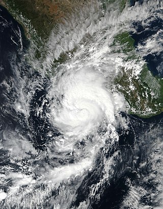
Hurricane Virgil was a late season hurricane of the 1992 Pacific hurricane season that struck southwestern Mexico in October 1992. Forming from a tropical wave that left Africa on September 13, it slowly developed into a tropical depression. It soon strengthened into Tropical Storm Virgil, and rapidly intensified into a hurricane on October 2. Continuing to intensify, the hurricane attained major hurricane strength, and peaked as a Category 4 hurricane off the coast of Mexico. Shortly before landfall, it weakened to a Category 2 hurricane, and it dissipated on October 5. Damage was generally minimal, though one person was reported missing.

Tropical Depression Five-E was a tropical depression which made landfall along the south-western Mexican coastline in July 2008. It was the fifth tropical cyclone of the 2008 Pacific hurricane season. The depression developed out of a weak tropical wave which formed off the coast of Africa on June 23. The wave remained poorly organized throughout its journey through the Atlantic Ocean and Caribbean Sea. The wave entered the Eastern Pacific on July 2 after passing through Central America. The wave developed into an area of low pressure that afternoon.

Hurricane Madeline was the second landfalling major hurricane along the Pacific coast of Mexico in a week. Madeline formed on September 29, not far from Central America. The next day, the circulation dissipated, and as a result weakened to a remnant low. Four days later, on October 3, the low regenerated into a tropical depression. The system remained weak for three days as it drifted west-northwest. When it began to recurve towards Mexico on October 6, the cyclone rapidly intensified and eventually made landfall at peak intensity as a Category 4. Shortly after landfall, the cyclone rapidly dissipated.

Hurricane Eugene was the only tropical cyclone to make landfall in Mexico during the 1987 Pacific hurricane season. The eighth tropical cyclone, fifth named storm, and first hurricane of the season, Eugene developed on July 22 from a tropical disturbance centered well offshore of Mexico. Later that day, the system intensified into a tropical storm while moving northwestward. Eugene reached hurricane status on July 24; it briefly peaked as a Category 2 hurricane the next day. Hurricane Eugene weakened back to a Category 1 hurricane; subsequently, the hurricane made landfall near Manzanillo. Shortly after landfall, Eugene rapidly weakened inland, and was only a tropical storm when it re-emerged into open water, where it quickly dissipated. Throughout southwestern Mexico, the storm produced high winds, especially in the southwestern portion of the country. The hurricane deluged the southwest Mexican coastline, resulting in the highest rainfall totals from a tropical cyclone in five Mexican states. Over 5,000 people were left homeless, including 60 in Manzanillo. The city's airport control tower was also damaged, requiring closure. Elsewhere, 200 to 300 houses were destroyed in Colima. In all, Eugene injured 18 people, and caused three fatalities and $142.12 million (1987 USD) in damage.
Tropical Storm Dolores was a strong tropical storm that affected several states in southwestern Mexico in June 2021. The fourth named storm of the 2021 Pacific hurricane season, Dolores developed from a low-pressure area that formed offshore the state of Oaxaca on June 16, 2021. The area steadily developed deep convection and a closed surface circulation, becoming Tropical Depression Four-E around 09:00 UTC on June 18. The depression quickly strengthened to Tropical Storm Dolores six hours later. As it gradually approached the coast, Dolores steadily intensified despite its proximity to land. It reached peak intensity at 15:00 UTC on June 19 with maximum sustained winds of 70 mph (115 km/h) and a minimum barometric pressure of 990 millibars (29 inHg), just below hurricane strength. Shortly afterward, Dolores made landfall just northwest of Punta San Telmo, Mexico, near the Colima-Michoacán state border. The storm rapidly weakened as it moved inland and dissipated early on June 20 over Zacatecas. However, the storm's mid-level circulation continued northward, before it dissipated later that day.

Hurricane Nora was a large tropical cyclone that made landfall in southern Mexico, and later went to affect Baja California. The fourteenth named storm, and fifth hurricane of the 2021 Pacific hurricane season, the system was first monitored by the National Hurricane Center (NHC) as an area of low pressure near the coast of Mexico. It intensified into Tropical Depression Fourteen-E, but the depression struggled to develop as a result of wind shear. It further intensified to a tropical storm and was named Nora as it tracked west-northwest. It peaked as a Category 1 hurricane with winds of 85 miles per hour (140 km/h) on August 28, before grazing the Mexico coastline and making landfall two separate times, dissipating on August 30. According to the National Hurricane Center's Tropical Cyclone Report, three direct deaths occurred as a result of Nora.
Hurricane Rick was the fifth named storm and fourth hurricane to make landfall along the Pacific coast of Mexico in 2021. The seventeenth named system and the eighth hurricane of the 2021 Pacific hurricane season, Rick formed as a low pressure system and was quickly upgraded to a tropical depression on October 21. Late on October 22, the storm was designated as a tropical storm and was given the name Rick. A few hours later, on October 23, the storm was upgraded to a hurricane. Rick continued to intensify and reached peak intensity early on October 25, making landfall as a Category 2 hurricane at 10:00 UTC that morning.


