
Tropical Storm Allison was a tropical storm that devastated southeast Texas in June of the 2001 Atlantic hurricane season. An arguable example of the "brown ocean effect", Allison lasted unusually long for a June storm, remaining tropical or subtropical for 16 days, most of which was when the storm was over land dumping torrential rainfall. The storm developed from a tropical wave in the northern Gulf of Mexico on June 4, 2001, and struck the upper Texas coast shortly thereafter. It drifted northward through the state, turned back to the south, and re-entered the Gulf of Mexico. The storm continued to the east-northeast, made landfall on Louisiana, then moved across the southeast United States and Mid-Atlantic. Allison was the first storm since Tropical Storm Frances in 1998 to strike the northern Texas coastline.

The 2002 Atlantic hurricane season was a near-average Atlantic hurricane season. It officially started on June 1, 2002, and ended on November 30, dates which conventionally limit the period of each year when most tropical cyclones develop in the Atlantic Ocean. The season produced fourteen tropical cyclones, of which twelve developed into named storms; four became hurricanes, and two attained major hurricane status. While the season's first cyclone did not develop until July 14, activity quickly picked up: eight storms developed in the month of September. It ended early however, with no tropical storms forming after October 6—a rare occurrence caused partly by El Niño conditions. The most intense hurricane of the season was Hurricane Isidore with a minimum central pressure of 934 mbar, although Hurricane Lili attained higher winds and peaked at Category 4 whereas Isidore only reached Category 3. However, Lili had a minimum central pressure of 938 mbar.

The 1971 Atlantic hurricane season was fairly active with several notable storms. Hurricane Edith, the strongest of the season, was a Category 5 on the Saffir-Simpson scale, the highest category on the scale, even though it was the least intense for that category on record, at 943 mbar. It struck Nicaragua at peak intensity, killing dozens, and later hit southern Louisiana. Until 2003, Hurricane Ginger held the record for the longest known duration of a North Atlantic tropical cyclone, lasting 27.25 days from early September to early October; it is currently the second longest-lasting Atlantic hurricane. Ginger moved ashore in North Carolina, producing heavy rains and damaging winds. An unnamed storm in August attained hurricane status further north than any other Atlantic hurricane. On 11 September, seven tropical cyclones were active at the same time, the record for the Atlantic basin.

Tropical Storm Allison was a tropical cyclone that produced severe flooding in the southern United States. The second tropical cyclone and the first named storm of the 1989 Atlantic hurricane season, Allison formed on June 24 in the northwestern Gulf of Mexico. Development of Allison was a result of the interaction of a tropical wave and the remnants of Pacific hurricane Hurricane Cosme. It moved south and became a tropical storm on June 26. By June 27, Allison made landfall near Freeport, Texas. Allison quickly weakened to a tropical depression later that day, and transitioned into an extratropical cyclone on the following day. However, the storm's remnants persisted for another 10 days and meandered across the area, triggering flooding across the region, before dissipating on July 7.

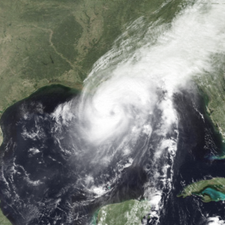
Hurricane Claudette was a moderately strong tropical cyclone that struck South Texas in July 2003. A fairly long-lived July Atlantic hurricane, Claudette was the fourth depression, third tropical storm and first hurricane of the 2003 Atlantic hurricane season. Claudette began as a tropical wave in the eastern Caribbean. It moved quickly westward, brushing past the Yucatán Peninsula before moving northwestward through the Gulf of Mexico. Claudette remained a tropical storm until just before making landfall in Port O'Connor, Texas, when it quickly strengthened to a strong Category 1 hurricane on the Saffir-Simpson Hurricane Scale. Forecasting of its path and intensity was uncertain throughout its lifetime, resulting in widespread and often unnecessary preparations along its path.

Tropical Storm Matthew was a weak tropical storm in the 2004 Atlantic hurricane season that made landfall on Louisiana. It was the thirteenth tropical storm of the season and the ninth to affect the United States. It formed over the western Gulf of Mexico on October 8 and struck south-central Louisiana two days later. The combination of the storm and an upper cyclone over the southern Plains brought heavy rains to much of the Gulf Coast, with the highest amounts reported over 15 inches (380 mm) in northern Louisiana. Damage was minimal, totaling $305,000 (2004 USD), and no casualties were reported.

Tropical Storm Frances caused extensive flooding in Mexico and Texas in September 1998. The sixth tropical cyclone and sixth named storm of the annual hurricane season, Frances developed from a low pressure area in the Gulf of Mexico on September 8. The cyclone moved northward through the western Gulf of Mexico, making landfall across the central Texas coastline before recurving across the Midwest through southeast Canada and New England. A large tropical cyclone for the Atlantic basin, yet an average sized system by western Pacific standards, the storm produced heavy rains across the Isthmus of Tehuantepec, Texas, western Louisiana and the Great Plains.

Tropical Storm Fay was the sixth named storm of the 2002 Atlantic hurricane season; it was a moderate tropical storm which caused flooding in parts of Texas and Northern Mexico. It formed from a trough of low pressure that moved south into the Gulf of Mexico, and became stationary. A low pressure center developed along this trough, and on September 5, a Hurricane Hunter aircraft reported that the system had gained sufficient organization to be classified a tropical depression, 95 miles (153 km) southeast of Galveston. The depression drifted south-southwest while strengthening, reaching its peak strength of 60 miles per hour (97 km/h) on the morning of September 6. The system then made an abrupt turn to the west-northwest, and remained steady in strength and course until landfall the next day, near Matagorda. The system weakened rapidly after landfall degenerating into a remnant low on September 8, but the storm's circulation survived for another three days.

Hurricane Jerry caused minor damage in Texas and flash flooding in Kentucky and Virginia in October 1989. The fourteenth tropical cyclone, tenth named storm, and seventh hurricane of the season, Jerry developed from a tropical wave in the Bay of Campeche on October 12. Initially a tropical depression, the system moved north-northwestward across the Gulf of Mexico and strengthened into Tropical Storm Jerry early on the following day. Jerry continuously deepened until October 14 and then maintained intensity while curving northeastward and briefly decelerating. Later that day, the storm re-curved north-northwestward. Jerry began to intensify on October 15 and soon became a Category 1 hurricane on the Saffir–Simpson hurricane wind scale. Early on October 16, Jerry made landfall on Galveston Island, Texas with winds of 85 miles per hour (137 km/h). Less than six hours later, Jerry weakened to a tropical storm and then a tropical depression shortly thereafter. Late on October 16, Jerry was absorbed by a frontal system while situated over southwestern Arkansas.

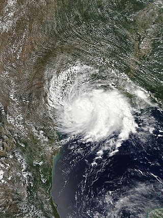
Tropical Storm Grace was a weak tropical storm that struck Texas in the 2003 Atlantic hurricane season. The eleventh tropical depression and the seventh tropical storm of the season, Grace was also the weakest storm of the season. On August 30 the storm developed from a long-track tropical wave in the western Gulf of Mexico. Grace remained disorganized throughout its lifetime due to an upper-level low to its west. The weak storm moved northwestward and made landfall on southeastern Texas. Grace quickly weakened over land, and dissipated on September 2 as it merged into a cold front.
Tropical Storm Bertha was a minimal tropical storm that made landfall twice along the Gulf Coast of the United States in August 2002. The second tropical storm of the 2002 Atlantic hurricane season, Bertha developed in the northern Gulf of Mexico out of a trough of low pressure that extended into the Atlantic on August 4. It quickly organized and reached tropical storm strength before making landfall on southeastern Louisiana. Bertha turned to the southwest over the state, and re-entered the Gulf of Mexico on August 7. It remained disorganized due to proximity to land, and after making landfall on south Texas, Bertha dissipated on August 9.

Tropical Storm Dean was a short-lived storm that formed in late July 1995 and lasted into early August. It was the fourth named storm of the 1995 Atlantic hurricane season. It spent most of its life as a tropical depression, and briefly gained tropical storm status before its landfall on the Texas coast on July 30. After landfall, it dissipated over central Texas on August 2. The impacts from Dean were minimal, mainly due to heavy rain in Oklahoma and Texas that caused localized coastal and inland flooding. Two F0 Tornadoes touched down in Texas as a result of Dean's landfall. Also, Twenty families had to be evacuated in Chambers County, due to flooding in the area. One fatality was recorded as a result of flooding in Oklahoma. Several highways were flooded out in Oklahoma, which impeded travel in the state. In addition approximately $500,000 worth of damage was recorded in the aftermath of Dean.
Hurricane Florence was the third of four named tropical cyclones to make landfall on the United States during the 1988 Atlantic hurricane season. The seventh tropical storm and second hurricane of the season, Florence developed on September 7 from an area of convection associated with a dissipating frontal trough in the southern Gulf of Mexico. After initially moving eastward, the storm turned northward and strengthened. Florence reached hurricane status and later peak winds of 80 mph (130 km/h) on September 9 shortly before striking southeastern Louisiana. The storm rapidly weakened over land and dissipated on September 11 over northeastern Texas.

Tropical Storm Chris caused minor flooding along the Gulf Coast of the United States in September 1982. The fifth tropical or subtropical cyclone and third named storm of the 1982 Atlantic hurricane season, Chris developed from a surface low-pressure area in the northern Gulf of Mexico on September 9. Although initially displaying subtropical characteristics, the low pressure area gradually acquired tropical characteristics, and was reclassified as Tropical Depression Four within 24 hours of development. The depression then began to intensify and was upgraded to Tropical Storm Chris on September 10. Thereafter, the storm turned north-north-eastward and strengthened further. On September 11, Chris peaked as a 65 mph (100 km/h) tropical storm. Later that day, it made landfall near Sabine Pass, Port Arthur, Texas. By September 13, Chris dissipated over Arkansas.

Tropical Storm Danielle caused considerable flooding in the state of Texas during September 1980. The eighth tropical cyclone and fourth named storm of the 1980 Atlantic hurricane season, Danielle developed from a tropical wave that emerged into the Atlantic Ocean from the west coast of Africa on August 22. Three days later, the tropical wave developed into a tropical depression. Four days later, the depression degenerated into a tropical wave. After tracking westward and entering the Gulf of Mexico, the system gradually developed, and became a tropical depression on September 4. The depression gradually strengthened and became Tropical Storm Danielle only hours before landfall in eastern Texas on September 5. Danielle steadily weakened inland and dissipated two days later.

Tropical Storm Candy produced minor impact in the state of Texas during the 1968 Atlantic hurricane season. The third tropical cyclone of the annual season, it developed from a tropical disturbance in the southwestern Gulf of Mexico on June 22. Gradual strengthening occurred, with the depression becoming Tropical Storm Candy on the following day. The storm reached its peak intensity of 70 mph (110 km/h) later that day and made landfall Port Aransas, Texas on June 23. Candy weakened into a tropical depression only hours after moving inland. However, the system remained a designated cyclone until June 26, at which time it completed extratropical transition over the state of Michigan.
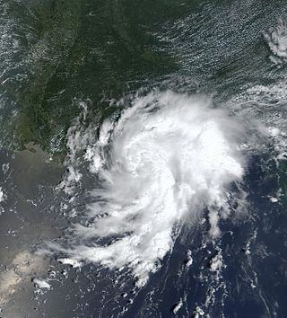
Tropical Storm Imelda was a tropical cyclone which was the fourth-wettest storm on record in the U.S. state of Texas, causing devastating and record-breaking floods in southeast Texas. The eleventh tropical cyclone and ninth named storm of the 2019 Atlantic hurricane season, Imelda formed out of an upper-level low that developed in the Gulf of Mexico and moved westward. Little development occurred until the system was near the Texas coastline, where it rapidly developed into a tropical storm before moving ashore shortly afterward on September 17. Imelda weakened after landfall, but continued bringing large amounts of flooding rain to Texas and Louisiana, before dissipating on September 21.


