Hurricane Ismael (1989)

Last updated
Map key
  Tropical depression (≤38 mph, ≤62 km/h)
  Tropical storm (39–73 mph, 63–118 km/h)
  Category 1 (74–95 mph, 119–153 km/h)
  Category 2 (96–110 mph, 154–177 km/h)
  Category 3 (111–129 mph, 178–208 km/h)
  Category 4 (130–156 mph, 209–251 km/h)
  Category 5 (≥157 mph, ≥252 km/h)
  Unknown
Storm type
Disc Plain black.svg Tropical cyclone
Solid black.svg Subtropical cyclone
ArrowUp.svg Extratropical cyclone, remnant low, tropical disturbance, or monsoon depression

Traces of Hurricane Ismael can be found from a tropical wave that emerged off of northwestern Africa back on July 31. [1] The trough passed through the Atlantic and Caribbean without any event. After passing through Central America without any significant convection or organization, the trough entered the Intertropical Convergence Zone (ITCZ) on August 11. [2]

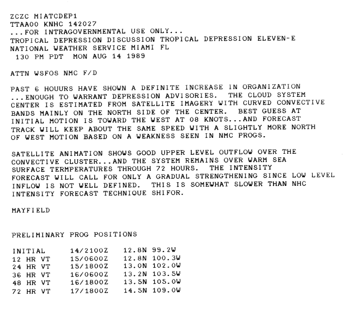
Three days later, after moving westward, the system began to better organize while still being off the coast of Mexico. [1] After significant increase in convection and organization, and satellite animation showing an organized upper-level outflow, the trough intensified to Tropical Depression Eleven-E on August 14. [1] [3] [4]

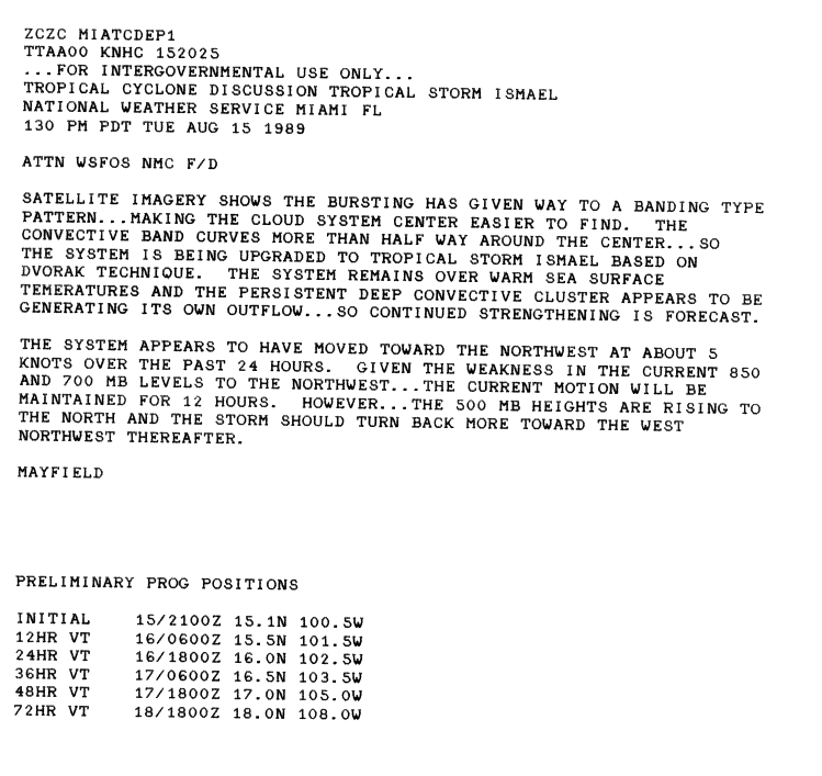
Just a day later, on August 15, Eleven-E had winds up to 35 mph with a barometric pressure of 1004 mbar and had intensified into a tropical storm based on the Dvorak technique. Eleven-E was designated as Tropical Storm Ismael on 8:30 UTC. [2] Ismael had developed rainbands which helped contribute to finding intensity. [2]

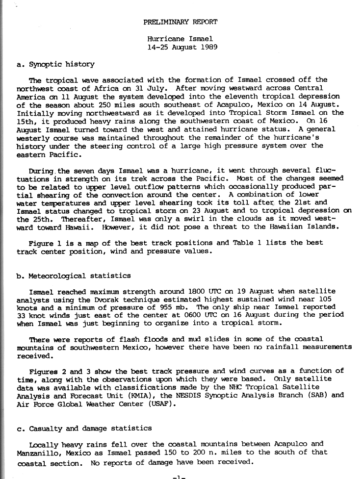
Ismael had produced heavy rain from Acapulco to the Sierra Madre del Sur Mountains as it skirted along the coast of Guerrero. [5] [6] Flash floods and mudslides had also occurred in the area. [6] 3 deaths had also occurred in the area. [7] On August 16, Ismael quickly intensified into a hurricane as it formed a visible eye at 8:30 UTC with winds up to 75 knots. Ismael had maintained a westerly course towards the Hawaiian Islands through the rest of its lifetime.

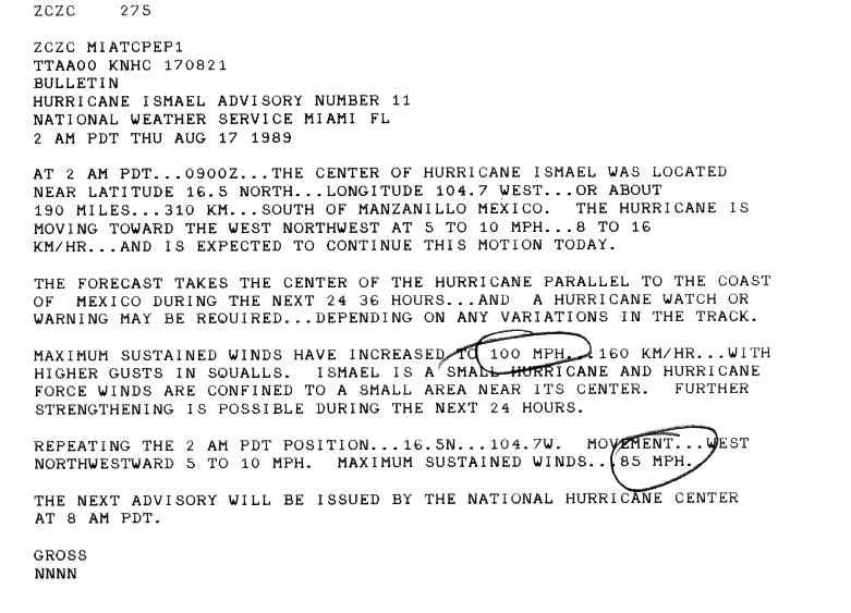
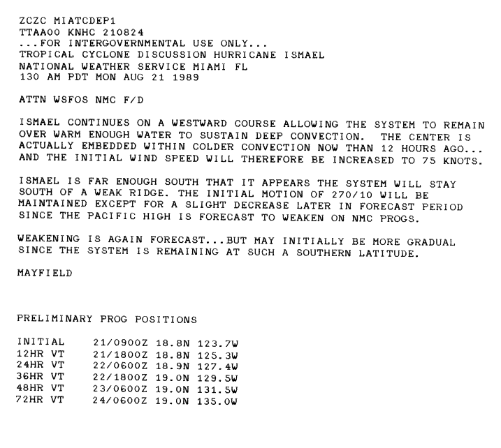
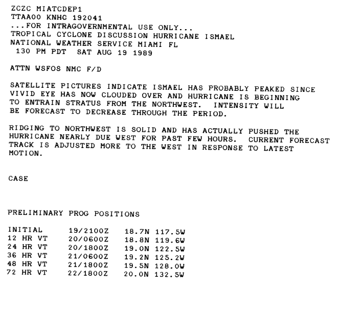
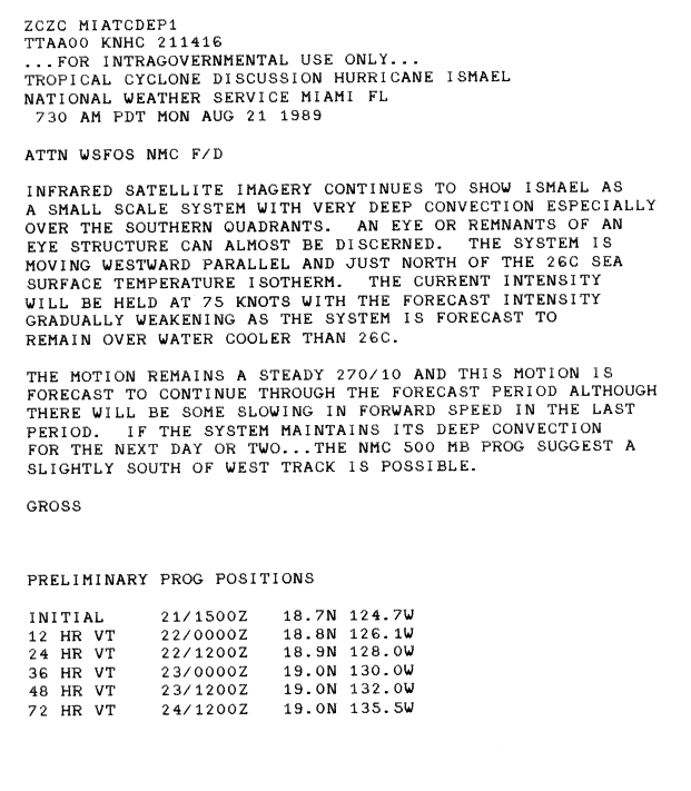
The system had intensified to Category 2 status at 12:00 UTC on August 17 with maximum sustained winds of 90 knots (100 mph). [4] [8] [9] Ismael weakened back to Category 1 status at 06:00 UTC, but two days later, reached its peak of 105 knots (121 mph) and reached Category 3 status at 18:00 UTC. [10] [11] [4] The eye of Ismael was clouded and soon, went through a period of degenerating after moving into colder waters. [10] While Ismael continued on its westward course, the system made contact with another tropical wave which eventually led to the formation of Tropical Storm Twelve-E. A few days later, the system intensified into Tropical Storm Juliette. Although going through a point of degeneration, Ismael still continued to show deep convection with winds of 75 knots (86 mph) on September 21. [12]

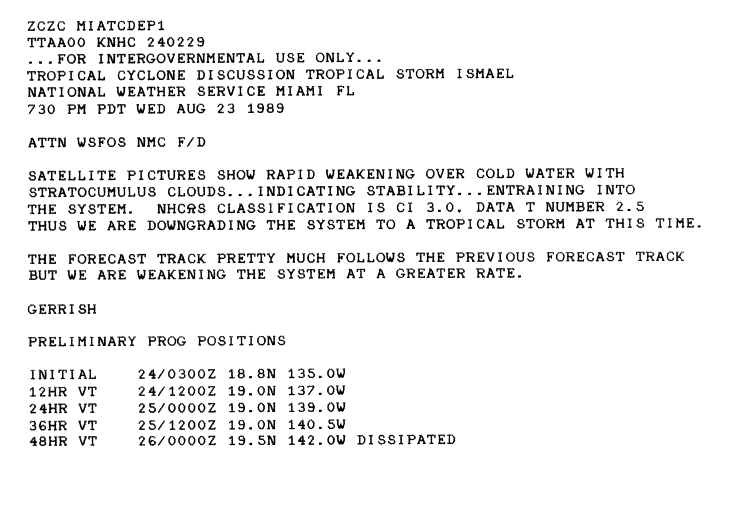
Ismael had intensified back to Category 2 status with 95 knots (109 mph) maximum sustained winds at 18:00 UTC the next day and continued a trend with rising and falling speeds. From August 23 – 24, Ismael had experienced rapid weakening. [13] The system went from a Category 2 hurricane to a tropical storm in a day. [9] [13] A sign of weakening from Ismael was an open vortex. Deep convection had decreased and an entry into cooler waters deteriorated Ismael's structure as well. [13] Ismael had degenerated into a tropical depression and soon, a remnant on the 25 of August. The remnants of Ismael headed towards Hawaii, but the government of Hawaii did not put any warnings. [9] The remnants dispersed on August 26. [9]

Impact

Although Hurricane Ismael did not make landfall, it did impact Mexico with rainfall from its rain bands. Ismael also killed 3 people while intensifying into a hurricane. One person by the name of Rhonda Santos was swept by Ismael's 8-foot waves and drowned off of Laguna Beach, in California. [14] The storm was 450 miles off the coast of San Diego, California. Two other people had also died from drowning due to Ismael's waves. [7] The system also brought heavy rains to Acapulco. Not much else was recorded.

See also

Related Research Articles

<span class="mw-page-title-main">2000 Atlantic hurricane season</span> Hurricane season in the Atlantic Ocean

The 2000 Atlantic hurricane season was a fairly active hurricane season, but featured the latest first named storm in a hurricane season since 1992. The hurricane season officially began on June 1, and ended on November 30. It was slightly above average due to a La Niña weather pattern although most of the storms were weak. It was also the only Season to Include 2 storms in Ireland. The first cyclone, Tropical Depression One, developed in the southern Gulf of Mexico on June 7 and dissipated after an uneventful duration. However, it would be almost two months before the first named storm, Alberto, formed near Cape Verde; Alberto also dissipated with no effects on land. Several other tropical cyclones—Tropical Depression Two, Tropical Depression Four, Chris, Ernesto, Nadine, and an unnamed subtropical storm—did not impact land. Five additional storms—Tropical Depression Nine, Florence, Isaac, Joyce, and Leslie—minimally affected land areas.

<span class="mw-page-title-main">2004 Pacific hurricane season</span> Hurricane season in the Pacific Ocean

The 2004 Pacific hurricane season was unusual in that no tropical cyclones of at least tropical storm intensity made landfall, the first such occurrence since 1991. The season was also below-average in terms of named storms and hurricanes, near-average in terms of major hurricanes. The season officially began on May 15 in the eastern Pacific, and on June 1 in the central Pacific; it officially ended in both basins on November 30. These dates conventionally delimit the period during each year when a majority of tropical cyclones form. The season was reflected by an accumulated cyclone energy (ACE) index of 71 units.

<span class="mw-page-title-main">2005 Pacific hurricane season</span> Hurricane season in the Pacific Ocean

The 2005 Pacific hurricane season was a near-average Pacific hurricane season which produced fifteen named storms, seven hurricanes and two major hurricanes. It was also the second consecutive season in which no tropical cyclone of at least tropical storm intensity made landfall. The season officially began on May 15 in the East Pacific Ocean, and on June 1 in the Central Pacific; they ended on November 30. These dates conventionally delimit the period of each year when most tropical cyclones form in the Pacific basin. However, the formation of tropical cyclones is possible at any time of the year.

<span class="mw-page-title-main">2003 Pacific hurricane season</span> Hurricane season in the Pacific Ocean

The 2003 Pacific hurricane season was the first season to feature no major hurricanes since 1977. The season officially began on May 15, 2003 in the Eastern North Pacific, and on June 1 in the Central ; both ended on November 30. These dates, adopted by convention, historically describe the period in each year when most tropical cyclogenesis occurs in these regions of the Pacific. The season featured 16 tropical storms, 7 of which intensified into hurricanes, which was then considered an average season. Damage across the basin reached US$129 million, and 23 people were killed by the storms.

<span class="mw-page-title-main">2001 Pacific hurricane season</span> Hurricane season in the Pacific Ocean

The 2001 Pacific hurricane season was a relatively near-average Pacific hurricane season which produced sixteen named storms, though most were rather weak and short-lived including one unnamed tropical storm which was operationally recognized as a tropical depression, the first such occurrence since 1996. Only eight hurricanes formed and two major hurricanes. The season officially began on May 15 in the East Pacific Ocean, and on June 1 in the Central Pacific; they ended on November 30. These dates conventionally delimit the period of each year when most tropical cyclones form in the Pacific basin. However, the formation of tropical cyclones is possible at any time of the year.

<span class="mw-page-title-main">2000 Pacific hurricane season</span> Hurricane season in the Pacific Ocean

The 2000 Pacific hurricane season was an above-average Pacific hurricane season, although most of the storms were weak and short-lived. There were few notable storms this year. Tropical storms Miriam, Norman, and Rosa all made landfall in Mexico with minimal impact. Hurricane Daniel briefly threatened the U.S. state of Hawaii while weakening. Hurricane Carlotta was the strongest storm of the year and the second-strongest June hurricane in recorded history. Carlotta killed 18 people when it sank a freighter. Overall, the season was significantly more active than the previous season, with 19 tropical storms. In addition, six hurricanes developed. Furthermore, there were total of two major hurricanes.

<span class="mw-page-title-main">1992 Pacific hurricane season</span> Hurricane season in the Pacific Ocean

The 1992 Pacific hurricane season is the most active Pacific hurricane season on record, featuring 27 named storms. The season also produced the second-highest ACE value on record in the basin, only surpassed by the 2018 season. The 1992 season officially started on May 15 in the eastern Pacific, and on June 1 in the central Pacific, and lasted until November 30. These dates conventionally delimit the period of each year when most tropical cyclones form in the northeastern Pacific Ocean. However, tropical cyclogenesis is possible at any time of the year, as demonstrated by the development of Hurricane Ekeka on January 28, and Tropical Storm Hali two months later.

<span class="mw-page-title-main">1989 Pacific hurricane season</span> Hurricane season in the Pacific Ocean

The 1989 Pacific hurricane season was a near normal season. It officially started on May 15, 1989, in the eastern Pacific, and on June 1, 1989, in the central Pacific, and lasted until November 30, 1989. These dates conventionally delimit the period of each year when most tropical cyclones form in the northeastern Pacific Ocean. A total of 18 storms and 9 hurricanes formed, which was near long-term averages. Four hurricanes reached major hurricane status on the Saffir–Simpson scale.

<span class="mw-page-title-main">2007 Pacific hurricane season</span> Hurricane season in the Pacific Ocean

The 2007 Pacific hurricane season was a well below-average Pacific hurricane season, featuring only one major hurricane. The season officially started on May 15 in the eastern Pacific and on June 1 in the central Pacific, and ended on November 30; these dates conventionally delimit the period during which most tropical cyclones form in the region. The first tropical cyclone of the season, Alvin, developed on May 27, while the final system of the year, Kiko, dissipated on October 23. Due to unusually strong wind shear, activity fell short of the long-term average, with a total of 11 named storms, 4 hurricanes, and 1 major hurricane. At the time, 2007 featured the second-lowest value of the Accumulated cyclone energy (ACE) index since reliable records began in 1971. Two tropical cyclones – Cosme and Flossie – crossed into the central Pacific basin during the year, activity below the average of 4 to 5 systems.

<span class="mw-page-title-main">2008 Pacific hurricane season</span> Hurricane season in the Pacific Ocean

The 2008 Pacific hurricane season was a near-average Pacific hurricane season which featured seventeen named storms, though most were rather weak and short-lived. Only seven storms became hurricanes, of which two intensified into major hurricanes. This season was also the first since 1996 to have no cyclones cross into the central Pacific. The season officially began on May 15 in the eastern Pacific and on June 1 in the central Pacific. It ended in both regions on November 30. These dates, adopted by convention, historically describe the period in each year when most tropical cyclone formation occurs in these regions of the Pacific. This season, the first system, Tropical Storm Alma, formed on May 29, and the last, Tropical Storm Polo, dissipated on November 5.

<span class="mw-page-title-main">2012 Pacific hurricane season</span> Hurricane season in the Pacific Ocean

The 2012 Pacific hurricane season was a moderately active Pacific hurricane season that saw an unusually high number of tropical cyclones pass west of the Baja California Peninsula. The season officially began on May 15 in the eastern Pacific Ocean, and on June 1 in the central Pacific (from 140°W to the International Date Line, north of the equator; they both ended on November 30. These dates conventionally delimit the period of each year when most tropical cyclones form in these regions of the Pacific Ocean. However, the formation of tropical cyclones is possible at any time of the year. This season's first system, Tropical Storm Aletta, formed on May 14, and the last, Tropical Storm Rosa, dissipated on November 3.

<span class="mw-page-title-main">Hurricane Fausto (2002)</span> Category 4 Pacific hurricane in 2002

Hurricane Fausto was a long-lived tropical cyclone that formed during the 2002 Pacific hurricane season, and later regenerated at an unusually high latitude over the north-central Pacific Ocean. Fausto was the eighth tropical cyclone, sixth named storm, fourth hurricane, and third major hurricane of the annual season. The storm developed on August 21 from a tropical wave that had crossed the Atlantic, and entered the Pacific on August 17. Becoming a tropical depression, the system intensified, and quickly became Tropical Storm Fausto early on August 22. Fausto rapidly intensified, and was already a hurricane on that same day as becoming a tropical storm. Rapid intensification continued, and the tropical cyclone ultimately peaked as a strong Category 4 hurricane on the Saffir–Simpson hurricane scale. At that time, the winds 145 mph (233 km/h). Fausto began to gradually weaken after attaining peak intensity on August 24, and was eventually downgraded to a tropical storm two days later. Weakening continued, and Fausto degenerated into a remnant low on August 28 while well northeast of Hawaii.

<span class="mw-page-title-main">2009 Pacific hurricane season</span> Hurricane season in the Pacific Ocean

The 2009 Pacific hurricane season was the most active Pacific hurricane season since 1997. The season officially started on May 15 in the East Pacific Ocean, and on June 1 in the Central Pacific; they both ended on November 30. These dates conventionally delimit the period of each year when most tropical cyclones form in the Eastern Pacific tropical cyclone basin; however, tropical cyclone formation is possible at any time of the year. The first system of the season, Tropical Depression One-E, developed on June 18, and the last, Hurricane Neki, dissipated on October 27, keeping activity well within the bounds of the season.

<span class="mw-page-title-main">Hurricane Juliette (1995)</span> Category 4 Pacific hurricane in 1995

Hurricane Juliette was the strongest hurricane and final tropical cyclone of the inactive 1995 Pacific hurricane season. The tenth named storm of the season, Juliette formed on September 16 from a tropical wave off the southwest coast of Mexico. For the majority of its track, the storm moved toward the west-northwest, and Juliette quickly intensified to major hurricane status. On September 20, the hurricane reached peak winds of 150 mph (240 km/h). Later it turned toward the northeast, briefly threatening the Baja California Peninsula, although the hurricane never affected land.

<span class="mw-page-title-main">2013 Pacific hurricane season</span> Hurricane season in the Pacific Ocean

The 2013 Pacific hurricane season was an above average Pacific hurricane season with 21 tropical cyclones forming. Of these, 20 became named storms – 18 in the Eastern Pacific basin, and 2 in the Central Pacific basin. Of the 18 named storms in the east, 9 became hurricanes, with one, Raymond, becoming the season's only major hurricane. In the central, neither named storm became a hurricane. It was also a below-normal season in terms of Accumulated cyclone energy (ACE), as many of its systems were weak and short-lived. The season officially began on May 15 in the Eastern Pacific and started on June 1 in the Central Pacific; both ended on November 30. These dates conventionally delimit the period of each year when most tropical development occurs in these North Pacific basins. The first cyclone, Tropical Storm Alvin, formed on May 15, and the last, Tropical Storm Sonia, dissipated on November 4.

<span class="mw-page-title-main">2014 Pacific hurricane season</span> Hurricane season in the Pacific Ocean

The 2014 Pacific hurricane season was the fifth-busiest season since reliable records began in 1949, alongside the 2016 season. The season officially started on May 15 in the East Pacific Ocean, and on June 1 in the Central Pacific; they both ended on November 30. These dates conventionally delimit the period of each year when most tropical cyclones form in the Pacific basin.

<span class="mw-page-title-main">2015 Pacific hurricane season</span> Hurricane season in the Pacific Ocean

The 2015 Pacific hurricane season is the second-most active Pacific hurricane season on record, with 26 named storms, only behind the 1992 season. A record-tying 16 of those storms became hurricanes, and a record 11 storms further intensified into major hurricanes throughout the season. The Central Pacific, the portion of the Northeast Pacific Ocean between the International Date Line and the 140th meridian west, had its most active year on record, with 16 tropical cyclones forming in or entering the basin. Moreover, the season was the third-most active season in terms of accumulated cyclone energy, amassing a total of 290 units. The season officially started on May 15 in the Eastern Pacific and on June 1 in the Central Pacific; they both ended on November 30. These dates conventionally delimit the period of each year when most tropical cyclones form in the Northeast Pacific basin. However, the formation of tropical cyclones is possible at any time of the year. This was shown when a tropical depression formed on December 31. The above-average activity during the season was attributed in part to the very strong 2014–16 El Niño event.

<span class="mw-page-title-main">Timeline of the 2013 Pacific hurricane season</span>

The 2013 Pacific hurricane season was an above-average year in which twenty named storms developed. The hurricane season officially began on May 15 in the East Pacific, coinciding with the formation of Tropical Storm Alvin, and on June 1 in the Central Pacific; it ended on November 30 in both basins. These dates conventionally delimit the period during each year when most tropical cyclones form. The final system of the year, Tropical Storm Sonia, dissipated on November 4.

<span class="mw-page-title-main">Hurricane Genevieve (2014)</span> Pacific hurricane and typhoon in 2014

Hurricane Genevieve, also referred to as Typhoon Genevieve, was the first tropical cyclone to track across all three northern Pacific basins since Hurricane Dora in 1999. Genevieve developed from a tropical wave into the eighth tropical storm of the 2014 Pacific hurricane season well east-southeast of Hawaii on July 25. However, increased vertical wind shear caused it to weaken into a tropical depression by the following day and degenerate into a remnant low on July 28. Late on July 29, the system regenerated into a tropical depression, but it weakened into a remnant low again on July 31, owing to vertical wind shear and dry air.

<span class="mw-page-title-main">2019 Pacific hurricane season</span> Hurricane season in the Pacific Ocean

The 2019 Pacific hurricane season was an above average season which produced nineteen named storms, most of which were rather weak and short-lived. Only seven hurricanes formed, the fewest since 2010. The season officially began on May 15 in the East Pacific Ocean, and on June 1 in the Central Pacific; they both ended on November 30. These dates conventionally delimit the period of each year when most tropical cyclones form in the Pacific basin. This season was one of the latest-starting Pacific hurricane seasons on record, with the first tropical cyclone, Hurricane Alvin, forming on June 25. The final system, Tropical Depression Twenty-One-E, dissipated on November 18.

References

  1. 1 2 3 Max Mayfield (August 14, 1989). "Tropical Depression Eleven-E Discussion 1". National Hurricane Center . Retrieved May 16, 2010.
  2. 1 2 3 Mayfield, Max (July 24, 1996). "Tropical Cyclone Discussion Tropical Storm Ismael (5)". National Oceanic and Atmospheric Administration . Retrieved March 29, 2021.
  3. Scientific and Technical Aerospace Reports. Scientific and Technical Information Office, National Aeronautics and Space Administration. 1990.
  4. 1 2 3 "Major Hurricane Ismael (12E) - 1989". tropicaleastpacific.com. Retrieved 2021-03-26.
  5. Mayfield, Max (July 24, 1997). "PRELIMINARY REPORT Hurricane Ismael". National Oceanic and Atmospheric Administration . Retrieved March 29, 2021.
  6. 1 2 "The Spokesman-Review - Google News Archive Search". news.google.com. Retrieved 2021-03-29.
  7. 1 2 Lawrence, Miles B. (1990-05-01). "Eastern North Pacific Hurricane Season of 1989". Monthly Weather Review. 118 (5): 1186–1193. Bibcode:1990MWRv..118.1186L. doi:10.1175/1520-0493(1990)118<1186:ENPHSO>2.0.CO;2. ISSN   1520-0493.
  8. "HURRICANE ISMAEL ADVISORY NUMBER 11". National Oceanic and Atmospheric Administration . July 24, 1997. Retrieved March 29, 2021.
  9. 1 2 3 4 Diagnostic Report of the National Hurricane Center. The Center. 1989.
  10. 1 2 "Tropical Cyclone Discussion Hurricane Ismael (27)". July 24, 1997.
  11. "Tropical Cyclone Discussion Hurricane Ismael (21)". National Oceanic and Atmospheric Administration . July 24, 1997. Retrieved March 29, 2021.
  12. "Tropical Cyclone Discussion Hurricane Ismael (28)". National Oceanic and Atmospheric Administration . July 24, 1997. Retrieved March 29, 2021.
  13. 1 2 3 "Tropical Cyclone Discussion Tropical Storm Ismael (38)". National Oceanic and Atmospheric Administration . July 24, 1997. Retrieved March 29, 2021.
  14. "Harlan Daily Enterprise - Google News Archive Search". Harlan Daily Enterprise. August 13, 1983. Retrieved March 30, 2021.
Hurricane Ismael
Ismael 1989-08-19 1600Z.png
Hurricane Ismael near its peak intensity on August 19