Tropical storm (39–73 mph, 63–118 km/h)
Category 1 (74–95 mph, 119–153 km/h)
Category 2 (96–110 mph, 154–177 km/h)
Category 3 (111–129 mph, 178–208 km/h)
Category 4 (130–156 mph, 209–251 km/h)
Category 5 (≥157 mph, ≥252 km/h)
Unknown
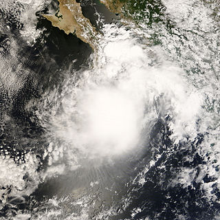
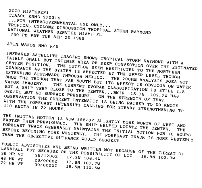
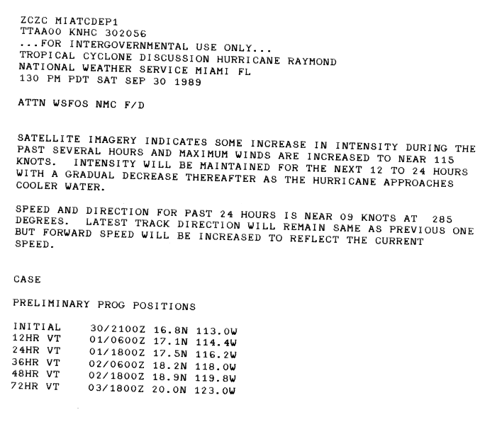
Hurricane Raymond originated out of a tropical wave that also spawned Hurricane Hugo in early September. With little convective development, the wave tracked westward across the Atlantic Ocean, entering the Caribbean several days later. By September 22, shower and thunderstorm activity increased as it crossed Central America and entered the eastern Pacific basin. By September 24, the wave had become sufficiently organized for the Dvorak Technique to be implemented on the system. The National Hurricane Center (NHC) estimated that the wave spawned Tropical Depression Twenty One-E about 200 miles (320 km) south of Acapulco, Mexico, on September 25. [1] Operationally, the NHC did not begin issuing advisories on the depression until September 26; at that time, the system's outflow developed and the depression was nearly stationary as a mid-level low over Mexico moved south. [2] Shortly after, the depression was upgraded to a tropical storm and given the name Raymond by the NHC. [1]
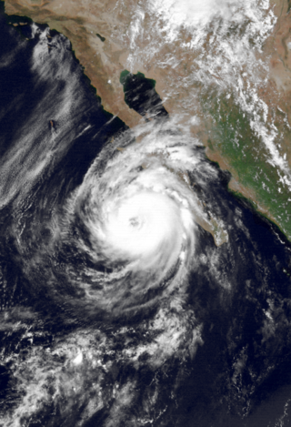
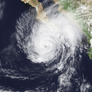
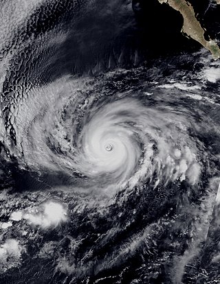
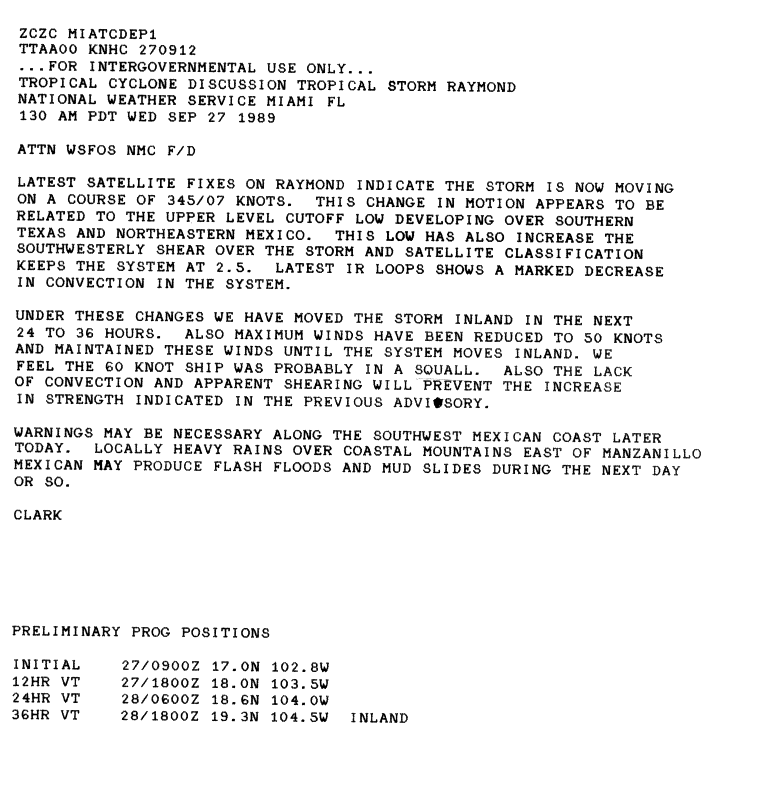
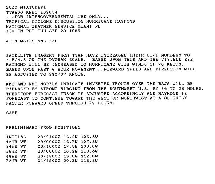
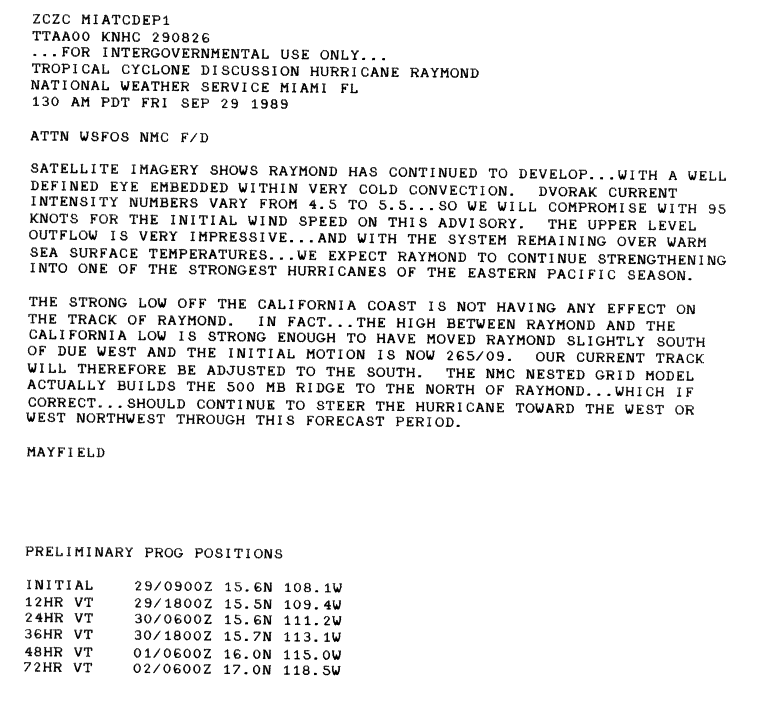
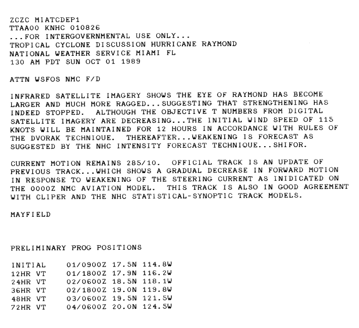
Raymond maintained a small area of deep convection around the center of circulation; however, outflow gradually became restricted due to the upper-level trough over Mexico. [3] Southerly wind shear around the storm began to increase late on September 27 in response to a cutoff low developing over southern Texas and northern Mexico; this led to a decrease in shower and thunderstorm activity with the system, preventing intensification. [4] By this time, the storm had resumed a general westward track. The following day, the storm intensified into a hurricane, the ninth and final of the season, [1] after an eye developed. [5] Throughout September 29, the eye became more defined on satellite imagery, indicating intensification. [6] Later that day, Raymond strengthened into a Category 4 hurricane. [7] Early on October 1, Raymond reached its peak intensity with winds of 145 mph (233 km/h) and a barometric pressure of 935 mbar (hPa; 27.61 inHg). [1] Shortly after, the eye increased in size but became less symmetrical, indicating that the storm was beginning to weaken. [8]
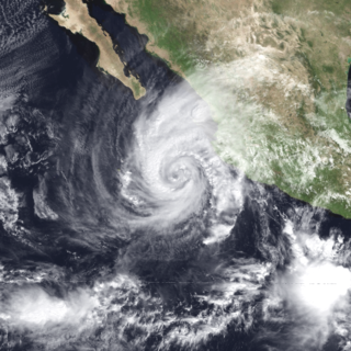
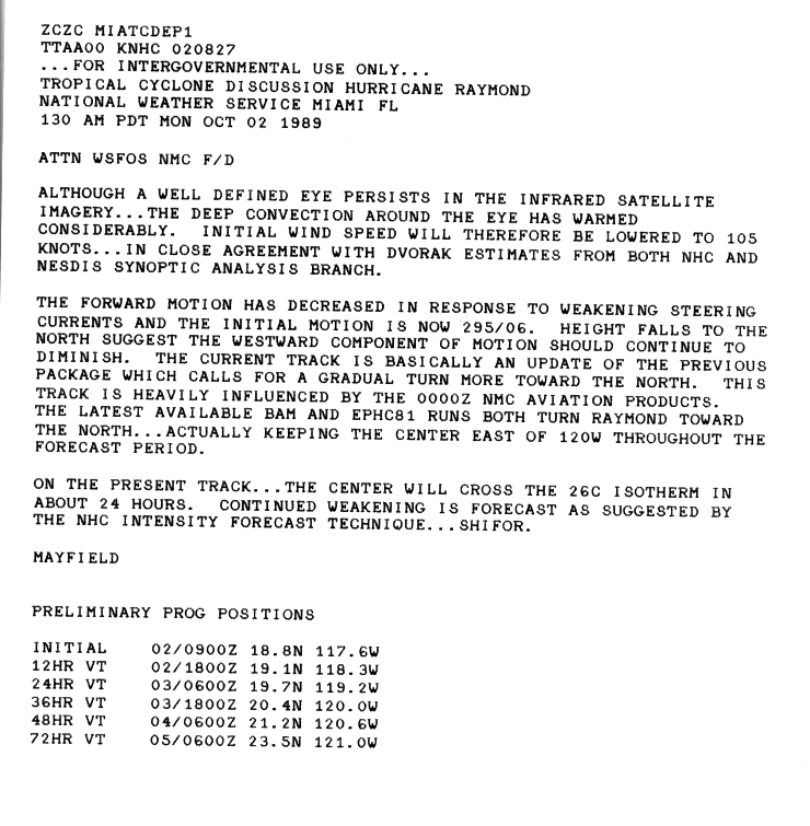
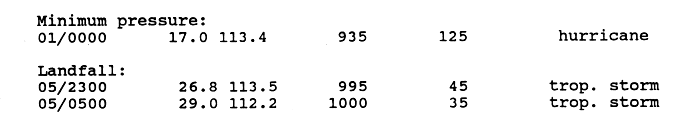
By October 2, convection surrounding the eye warmed and Raymond was downgraded to a Category 3 hurricane as it began to slow in a weak steering environment. [9] Early the next day, the now Category 2 hurricane turned northeast and quickly accelerated in response to an approaching long-wave trough. Later on October 3, the cyclone further weakened to a Category 1 storm [1] as an eye was no longer present in the circulation. [10] Increasing wind shear and decreasing water temperatures sped up the rate of weakening as Raymond approached the Baja California Peninsula. [1] Around 2300 UTC on October 4, the center of the storm made landfall in the municipality of Ensenada in Mexican state of Baja California with winds of 50 mph (80 km/h). [11] After briefly crossing the Gulf of California, [1] the storm made its second and final landfall in the state of Sonora with winds of 40 mph (64 km/h). [11] Shortly after moving inland, Raymond weakened to a tropical depression and quickly transitioned into an extratropical cyclone over Arizona in the Southwest United States. [1] The upper-level remnants of the hurricane persisted until October 7 over the Midwest region. [12]
Preparations and impact
Mexico

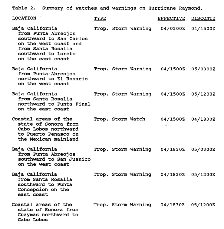
Around 0300 UTC on October 4, the Government of Mexico issued a tropical storm warning for areas between Punta Abreojos and San Carlos on the Pacific coast of Baja California and for areas between Santa Rosalía to Loreto on the Gulf coast of the Peninsula. Roughly twelve hours later, the warning was superseded by another tropical storm warning. The new warning was issued for areas between Punta Abreojos and El Rosario on the Pacific coast and for areas between Santa Rosalia and Punta Final on the Gulf coast. In mainland Mexico, a tropical storm watch was issued for coastal areas of Sonora between Cabo Lobos and Puerto Penasco. By 1830 UTC, all of the watches and warnings were revised; on the Pacific coast of Baja California, the warning was in effect for areas between Punta Abreojos and San Juanico; on the Gulf coast, the warning was in effect for areas between Santa Rosalia and Punta Conception; the watch for coastal areas of Sonora was upgraded to a tropical storm warning for areas between Guaymas and Cabo Lobos. Following Raymond's landfall in mainland Mexico, all warnings were discontinued by 1200 UTC on October 5. [13]
Since Raymond had significantly weakened prior to its first landfall, only minor impacts were recorded in Mexico. The fast forward speed of the storm limited the amount of rain in the Baja California Peninsula, with only a small area receiving more than 3 in (76 mm). [14] The highest rainfall was recorded in Nogales at 4.72 in (120 mm). [12] In the city, the swollen Santa Cruz River destroyed a heavily traveled bridge, known as the Calle Obregon, and a store which was situated on the banks of the river. Mexican officials estimated damages in Nogales at $250,000. [15]
United States

The day prior to Raymond's impacts in the United States, weather forecasts in Arizona indicated that heavy rainfall associated with the remnants of the storm were likely to trigger flash flooding and landslides, with rainfall rates reaching 0.5 in/h (12.5 mm/h). [16] Flash flood watches were issued for parts of southern Arizona as well as mountainous and northern parts of New Mexico between October 5 and 6. [17] Rainfall in excess of 3 in (76 mm) fell in parts of southern Arizona; with the highest in the state recorded near Tucson at 4.5 in (110 mm). Several locations recorded wind gusts up to 35 mph (56 km/h); however, mountaintops possibly received winds in excess of 40 mph (64 km/h). [18] The highest total in the United States was recorded in Independence, Kansas at 3.91 in (99 mm). [12]
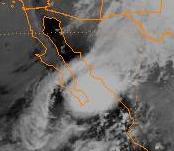
Fifteen streets in the city of Tucson were closed as floodwaters reached 2 ft (0.61 m) in the worst hit areas. [18] The Tucson Electric Power Company reported that parts of the city were without power for eight hours on October 5 due to the storm. [15] The hardest hit area was Willcox; roughly 75% of the city was under 2 ft (0.61 m) of floodwaters. [18] Runoff, mixed with sewage, contaminated a wastewater-treatment plant; cleanup took several days before the plant was operational. Several businesses were flooded, with the Wilcox Auction Barn and the Wapco Apple Packing Plant both containing about 1 ft (0.30 m) of water. The Sulphur Springs Valley Electric Company shut off power to flooded areas as a safety precaution. In Fort Huachuca, power lines were downed, leading to early dismissal of army classes. [15] One person was killed in relation to Raymond after being trapped in a mobile home which was destroyed by high winds. [19] Flash flooding triggered by Raymond caused an estimated $1.5 million in damage throughout Arizona. [20]
See also
Related Research Articles

The 1996 Pacific hurricane season had below normal tropical cyclone activity, producing 9 tropical storms, of which 5 became hurricanes, with 2 of those intensifying into major hurricanes. With an Accumulated cyclone energy (ACE) index of 53.9, the season ranks among the least intense Pacific hurricane seasons on record. It officially began May 15, 1996, in the eastern north Pacific and on June 1, 1996, in the central north Pacific. It ended on November 30, 1996. These dates conventionally delimit the period of each year when most tropical cyclones form in the northeastern Pacific Ocean. The season slightly exceeded these bounds when tropical storm One-E formed on May 13.

The 1995 Pacific hurricane season was the least active Pacific hurricane season since 1979, and marked the beginning of a multi-decade period of low activity in the basin. Of the eleven tropical cyclones that formed during the season, four affected land, with the most notable storm of the season being Hurricane Ismael, which killed at least 116 people in Mexico. The strongest hurricane in the season was Hurricane Juliette, which reached peak winds of 150 mph (240 km/h), but did not significantly affect land. Hurricane Adolph was an early-season Category 4 hurricane. Hurricane Henriette brushed the Baja California Peninsula in early September.

The 1994 Pacific hurricane season was the final season of the eastern north Pacific's consecutive active hurricane seasons that started in 1982. The season officially started on May 15, 1994, in the eastern Pacific, and on June 1, 1994, in the central Pacific, and lasted until November 30, 1994. These dates conventionally delimit the period of each year when most tropical cyclones form in the northeastern Pacific Ocean. The first tropical cyclone formed on June 18, while the last system dissipated on October 26. This season, twenty-two tropical cyclones formed in the north Pacific Ocean east of the dateline, with all but two becoming tropical storms or hurricanes. A total of 10 hurricanes occurred, including five major hurricanes. The above average activity in 1994 was attributed to the formation of the 1994–95 El Niño.

The 1992 Pacific hurricane season is the most active Pacific hurricane season on record, featuring 27 named storms. The season also produced the second-highest ACE value on record in the basin, only surpassed by the 2018 season. The 1992 season officially started on May 15 in the eastern Pacific, and on June 1 in the central Pacific, and lasted until November 30. These dates conventionally delimit the period of each year when most tropical cyclones form in the northeastern Pacific Ocean. However, tropical cyclogenesis is possible at any time of the year, as demonstrated by the development of Hurricane Ekeka on January 28, and Tropical Storm Hali two months later.

The 1990 Pacific hurricane season was a very active season which observed 21 named storms within the basin. The season also produced the fourth highest ACE index value on record. The season was officially started on May 15 in the eastern Pacific, and on June 1 in the central Pacific, and lasted until November 30. These dates conventionally delimit the period of each year when most tropical cyclones form in the northeastern Pacific Ocean. However, the formation of tropical cyclones is possible at any time of the year, as illustrated in 1990 by the formation of the season's first named storm, Hurricane Alma, on May 12. At the time, this was the earliest formation of a tropical storm on record in the eastern Pacific

The 1989 Pacific hurricane season was a near normal season. It officially started on May 15, 1989, in the eastern Pacific, and on June 1, 1989, in the central Pacific, and lasted until November 30, 1989. These dates conventionally delimit the period of each year when most tropical cyclones form in the northeastern Pacific Ocean. A total of 18 storms and 9 hurricanes formed, which was near long-term averages. Four hurricanes reached major hurricane status on the Saffir–Simpson scale.

The 1983 Pacific hurricane season was the longest season ever recorded at that time. It was a very active Pacific hurricane season. The season started on May 15, 1983 in the eastern Pacific, and on June 1, 1983 in the central Pacific, and lasted until November 30, 1983. These dates conventionally delimit the period of each year when most tropical cyclones form in the northeastern Pacific Ocean. During the 1983 season, there were 20 named storms, which was slightly less than the previous season. Furthermore, twelve of those storms became hurricanes. And eight of the storms reached major hurricane status, or Category 3 or higher on the Saffir–Simpson hurricane wind scale (SSHWS). The decaying 1982–83 El Niño event likely contributed to this level of activity. That same El Niño influenced a very quiet Atlantic hurricane season.

Hurricane Javier was a powerful tropical cyclone whose remnants brought above-average rainfall totals across the western United States in September 2004. Javier was the tenth named storm, the sixth hurricane and the final major hurricane of the 2004 Pacific hurricane season. Javier was also the strongest hurricane of the 2004 season, with 150 mph (240 km/h) winds and a central pressure of 930 millibars. However, because of high wind shear in the East Pacific, Javier weakened rapidly before making landfall in Baja California as a tropical depression. The remnants of the storm then continued moving northeast through the Southwestern United States. Javier caused no direct fatalities, and the damage in Mexico and the United States was minimal.
Hurricane Lester was the first Pacific tropical cyclone to enter the United States as a tropical storm since 1967. The fourteenth named storm and eighth hurricane of the 1992 Pacific hurricane season, Lester formed on August 20 from a tropical wave southwest of Mexico. The tropical storm moved generally northwestward while steadily intensifying. After turning to the north, approaching the Mexican coast, Lester attained hurricane status. The hurricane reached peak winds of 85 mph (137 km/h) before making landfall on west-central Baja California. The system weakened while moving across the peninsula and then over northwestern Mexico. Not long after entering Arizona, Lester weakened to a tropical depression, and degenerated into an extratropical low on August 24, 1992, over New Mexico. The storm's remnants later merged with the remnants of Hurricane Andrew and another frontal system on August 29.
Hurricane Fausto was a Pacific hurricane that caused light damage to Baja California Sur in September 1996. On September 10, a tropical depression developed a short distance south-southeast of the Mexican Riviera. Slowly intensifying, Fuasto paralleled the coastline. It became a hurricane on September 12, and after briefly reaching major hurricane intensity, increasing wind shear resulted in a weakening trend. It traversed Baja California Sur on September 13 as minimal hurricane, and struck Sinaloa the next day. Inland, it degenerated into a remnant circulation by September 15. Fausto's remnants continued moving eastward across the Gulf of Mexico and later emerged into the Atlantic, before developing into a large nor'easter on September 17. Afterward, the system moved northeastward, before it was last noted on September 18.
Tropical Storm Julio was a tropical storm that made landfall on the southern tip of Baja California Sur in August 2008. The eleventh named storm of the 2008 Pacific hurricane season, it developed from a tropical wave on August 23 off the coast of Mexico. It moved parallel to the coast, reaching peak winds of 50 mph (85 km/h) before moving ashore and weakening. On August 26 it dissipated in the Gulf of California. Julio was the third tropical cyclone to make landfall in the Eastern Pacific tropical cyclone basin during the season, after Tropical Storm Alma, which struck Nicaragua in May, and Tropical Depression Five-E, which moved ashore along southwestern Mexico in July. The storm brought locally heavy rainfall to southern Baja California, killing one person and leaving several towns isolated. Moisture from Julio reached Arizona, producing thunderstorms, including one which damaged ten small planes in Chandler.
Hurricane Rosa was the only Pacific hurricane to make landfall during the above-average 1994 Pacific hurricane season. It killed at least 4 people in Mexico. Moisture from the hurricane was a factor in widespread flooding in the U.S. state of Texas that killed 22 people and caused hundreds of millions of dollars in damage in October 1994. The pre-Rosa tropical depression formed on October 8 before degenerating the next day. It reformed on October 10 and steadily strengthened as it approached Mexico. Ultimately peaking as a Category 2 hurricane on the Saffir-Simpson Hurricane Scale right before landfall, Rosa was the final hurricane, nineteenth tropical storm, and second-last tropical cyclone of the 1994 Pacific hurricane season.

Hurricane Kiko was one of the strongest tropical cyclones on record to have made landfall on Mexico's Baja California peninsula. The eleventh named storm of the 1989 Pacific hurricane season, Kiko formed out of a large mesoscale convective system on August 25. Slowly tracking northwestward, the storm rapidly intensified into a hurricane early the next day. Strengthening continued until early August 27, when Kiko reached its peak intensity with winds of 120 mph (190 km/h). The storm turned west at this time, and at around 0600 UTC, the storm made landfall near Punta Arena, Mexico at the southern tip of Baja California Sur. The hurricane rapidly weakened into a tropical storm later that day and further into a tropical depression by August 28, shortly after entering the Pacific Ocean. The depression persisted for another day while tracking southward, before being absorbed by nearby Tropical Storm Lorena. Though Kiko made landfall as a Category 3 hurricane, its impact was relatively minor. Press reports indicated that 20 homes were destroyed and numerous highways were flooded by torrential rains.

Tropical Storm Cristina was the third tropical cyclone to make landfall along the Pacific Coast of Mexico in 10 days. On July 1, an area of disturbed weather developed into a tropical depression off the coast of Central America. The depression strengthened into Tropical Storm Cristina on July 2 as it moved west-northwest. Cristina was almost a hurricane at the time of its landfall near Puerto Ángel on July 3. The cyclone dissipated over the mountains of Mexico on the same day. Tropical Storm Cristina claimed 13 lives and left 62 missing. Eleven fishing boats were reported missing and 350 people were left homeless

Hurricane Jimena is tied with Hurricane Norbert as the strongest tropical cyclone to make landfall on western portion of the Baja California Peninsula. Jimena was the twelfth named storm, fifth hurricane, third major hurricane and overall second-strongest tropical cyclone of the 2009 Pacific hurricane season. Forming from a tropical wave late on August 28, 2009, off of Mexico's Pacific coast, the system rapidly intensified into a Category 2 hurricane on the next day. Two days after developing, Jimena strengthened into a Category 4 hurricane. After peaking close to Category 5 intensity on September 1, it encountered cold water and began to weaken. When the hurricane made landfall on the Baja California Peninsula on September 3, it was only a Category 2 hurricane. On the next day, the tropical cyclone entered the Gulf of California, though the storm weakened into a remnant low after looping back eastward towards Baja California. The storm's remnants drifted westward into the Pacific afterward, before dissipating on September 8.
Tropical Storm Rachel was the only tropical cyclone to make landfall during the 1990 Pacific hurricane season. The twenty-fourth tropical depression and eighteenth named storm, Rachel developed on September 27 from a tropical wave southwest of mainland Mexico. After becoming a tropical depression, the system tracked slowly southwestward and eventually curved northwestward. The depression intensified into a tropical storm after three days and was named Rachel by the National Hurricane Center. Rachel continued to steadily strengthen, and peaked as a strong 65 mph (100 km/h) tropical storm on October 2. After attaining peak intensity, Rachel re-curved to make a landfall in southern Baja California Sur and again in the Mexican Mainland on October 3. The storm produced heavy rainfall across northern Mexico and the Southwestern United States. Thousands of people were left homeless and 18 fatalities were reported.

Hurricane Hilary was a Category 3 hurricane during the 1993 Pacific hurricane season that brought significant rainfall to the Sonoran Desert region of Mexico and the United States in August of that year. Additionally, its remnants in part caused significant flooding in the Midwestern United States. A westward moving tropical depression gradually developed on August 17 south of the Mexican coast, attaining hurricane status two days later. The storm further intensified into a Category 3 hurricane, attaining peak winds of 120 mph (195 km/h). By August 23, the hurricane nearly stalled while interacting with Tropical Storm Irwin. Executing a small counter-clockwise loop, Hilary degraded to tropical storm intensity and took a northerly track for the remainder of its existence. The storm made two landfalls in Mexico, one in Baja California Sur on August 25 and one in Sonora the following day. Tropical cyclone warnings and watches were issued for much of the southern Mexican coastline; however, they were later discontinued when the threat ended, but were issued again when the system posed a threat to the Baja California Peninsula. Hilary dropped in excess of 5 in (130 mm) rain along its path in some areas, and flash flooding in California and Iowa.

Tropical Storm Lidia was a large tropical cyclone that caused flooding in Baja California Peninsula and parts of western Mexico. The fourteenth tropical cyclone and twelfth named storm of the 2017 Pacific hurricane season, Lidia developed from a large area of disturbed weather west of the Pacific Coast of Mexico on August 31. The storm intensified while moving generally northward or northwestward, peaking with maximum sustained winds of 65 mph (105 km/h) later that day. On September 1, Lidia made landfall in Mexico near Puerto Chale, Baja California Sur, at peak intensity. The storm weakened while traversing the peninsula, ultimately emerging over the Pacific Ocean on September 3, where the storm degenerated into a remnant low. The system brought thunderstorms and wind gusts to Southern California, before dissipating on September 4.
Hurricane Rosa brought widespread flooding to northwestern Mexico and the Southwestern United States in late September 2018, and was the first tropical cyclone to make landfall in Baja California since Nora in 1997. The seventeenth named storm, tenth hurricane, and seventh major hurricane of the 2018 Pacific hurricane season; Rosa originated from an Atlantic tropical wave that crossed the West African coast on September 6. The wave proceeded westward across the Atlantic, traversing Central America before entering the Gulf of Tehuantepec on September 22. There, the weather system acquired cyclonic features and became a tropical storm on September 25. Within a favorable atmosphere, Rosa entered a period of rapid intensification on September 27, peaking as a Category 4 hurricane with maximum sustained winds of 150 mph (240 km/h) a day later. Over the next few days, Rosa turned north and then northeast while steadily weakening, making landfall in Baja California as a tropical depression on October 2. After crossing over into the Gulf of California, the remnant system split apart and merged with an upper-level low off the coast of California by October 3.
References
- 1 2 3 4 5 6 7 8 Max Mayfield (November 18, 1989). "Hurricane Raymond Preliminary Report Page 1". National Hurricane Center. Retrieved May 27, 2009.
- ↑ Max Mayfield (September 26, 1989). "Tropical Depression Twenty One-E Discussion Number One". National Hurricane Center. Retrieved May 29, 2009.
- ↑ Staff Writer (September 26, 1989). "Tropical Storm Raymond Discussion Number Three". National Hurricane Center. Retrieved May 29, 2009.
- ↑ Clark (September 27, 1989). "Tropical Storm Raymond Discussion Number Four". National Hurricane Center. Retrieved May 29, 2009.
- ↑ Case (September 28, 1989). "Hurricane Raymond Discussion Number Ten". National Hurricane Center. Retrieved August 31, 2009.
- ↑ Max Mayfield (September 29, 1989). "Hurricane Raymond Discussion Number Twelve". National Hurricane Center. Retrieved September 3, 2009.
- ↑ Case (September 30, 1989). "Hurricane Raymond Discussion Number Eighteen". National Hurricane Center. Retrieved September 3, 2009.
- ↑ Max Mayfield (October 1, 1989). "Hurricane Raymond Discussion Number Twenty". National Hurricane Center. Retrieved September 4, 2009.
- ↑ Max Mayfield (October 2, 1989). "Hurricane Raymond Discussion Number Twenty-Four". National Hurricane Center. Retrieved September 4, 2009.
- ↑ Clark (October 3, 1989). "Hurricane Raymond Discussion Twenty-Nine". National Hurricane Center. Retrieved September 4, 2009.
- 1 2 Max Mayfield (November 18, 1989). "Hurricane Raymond Preliminary Report Page 5". National Hurricane Center. Retrieved September 4, 2009.
- 1 2 3 David M. Roth (2009). "Hurricane Raymond - October 4–7, 1989". Hydrometeorological Prediction Center. Retrieved May 26, 2009.
- ↑ Max Mayfield (November 18, 1989). "Hurricane Raymond Preliminary Report Page 6". National Hurricane Center. Retrieved May 28, 2009.
- ↑ Miles B. Lawrence (1990). "Monthly Weather Review: Eastern North Pacific Hurricane Season of 1989" (PDF). Monthly Weather Review. National Hurricane Center. 118 (5): 1186–1193. Bibcode:1990MWRv..118.1186L. doi:10.1175/1520-0493(1990)118<1186:ENPHSO>2.0.CO;2. ISSN 1520-0493 . Retrieved May 27, 2009.
- 1 2 3 "Rains Flood Wilcox, Nogales". Casa Grande Dispatch. Associated Press. October 6, 1989.
- ↑ "Heavy rains expected". Casa Grande Dispatch. Associated Press. October 4, 1989.
- ↑ "Forecast: National Summary". The Post-Standard. October 6, 1989.
- 1 2 3 National Weather Service Forecast Office in Tucson, Arizona (1989). "Hurricane Raymond 1989". National Oceanic and Atmospheric Administration. Retrieved May 27, 2009.
- ↑ Staff Writer (October 6, 1989) Showers roll across central U.S. United Press International
- ↑ Max Mayfield (November 18, 1989). "Hurricane Raymond Preliminary Report Page 2". National Hurricane Center. Retrieved May 26, 2009.
External links
 Hurricane Raymond near peak intensity on September 30 |
Tropical cyclones of the 1989 Pacific hurricane season | ||
|---|---|---|
 | ||