
The 2004 Pacific hurricane season was an overall below-average Pacific hurricane season in which there were 12 named tropical storms, all of which formed in the eastern Pacific basin. Of these, 6 became hurricanes, and 3 of those intensified into major hurricanes. No storms made landfall in 2004, the first such occurrence since 1991. In addition to the season's 12 named storms, there were five tropical depressions that did not reach tropical storm status. One of them, Sixteen-E, made landfall in northwestern Sinaloa. The season officially began on May 15 in the eastern Pacific, and on June 1 in the central Pacific basin. It officially ended in both basins on November 30. These dates conventionally delimit the period during each year when most tropical cyclones form in each respective basin. These dates conventionally delimit the period during each year when a majority of tropical cyclones form. The season was reflected by an accumulated cyclone energy (ACE) index of 71 units.

Hurricane Jimena was a strong tropical cyclone that brushed Hawaii in early September 2003. It was the tenth named storm and second hurricane of the 2003 Pacific hurricane season. Jimena formed on August 28th in the far western portion of the Eastern Pacific Ocean at approximately 129.6°W as a tropical depression and moved westward where it rapidly became a hurricane the following day. The storm moved westward into the Central Pacific Ocean where it became a Category 2 hurricane on the Saffir–Simpson Hurricane Scale. After reaching its peak strength as a Category 2 hurricane, the storm began to weaken due to increasing wind shear. Jimena brushed past the Hawaiian Islands before becoming a tropical depression on September 3. The weakening storm then crossed the international dateline before dissipating on September 5, becoming one of the few storms to cross both 140ºW and International Date Line.

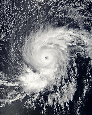
Hurricane Dora was one of few tropical cyclones to track across all three north Pacific basins and the first since Hurricane John in 1994. The fourth named storm, third hurricane, and second major hurricane of the 1999 Pacific hurricane season, Dora developed on August 6 from a tropical wave to the south of Mexico. Forming as a tropical depression, the system gradually strengthened and was upgraded to Tropical Storm Dora later that day. Thereafter Dora began heading in a steadily westward direction, before becoming a hurricane on August 8. Amid warm sea surface temperatures and low wind shear, the storm continued to intensify, eventually peaking as a 140 mph (220 km/h) Category 4 hurricane on August 12.
Hurricane Flossie was a powerful Pacific tropical cyclone that brought squally weather and light damage to Hawaii in August 2007. The sixth named storm, second hurricane, first and only major hurricane of the inactive 2007 Pacific hurricane season, Flossie originated from a tropical wave that emerged off Africa on July 21. After traversing the tropical Atlantic, the wave crossed Central America and entered the eastern Pacific on August 1. There, a favorable environment allowed it to become a tropical depression and a tropical storm shortly thereafter on August 8.

The 2014 Pacific hurricane season was one of the busiest and costliest Pacific hurricane seasons since the keeping of reliable records began in 1949. The season officially started on May 15 in the East Pacific Ocean, and on June 1 in the Central Pacific; they both ended on November 30. These dates conventionally delimit the period of each year when most tropical cyclones form in these regions of the Pacific.

The 2015 Pacific hurricane season is the second-most active Pacific hurricane season on record, with 26 named storms, only behind the 1992 season. A record-tying 16 of those storms became hurricanes, and a record 11 storms further intensified into major hurricanes throughout the season. The Central Pacific, the portion of the Northeast Pacific Ocean between the International Date Line and the 140th meridian west, had its most active year on record, with 16 tropical cyclones forming in or entering the basin. Moreover, the season was the third-most active season in terms of accumulated cyclone energy, amassing a total of 290 units. The season officially started on May 15 in the Eastern Pacific and on June 1 in the Central Pacific; they both ended on November 30. These dates conventionally delimit the period of each year when most tropical cyclones form in the Northeast Pacific basin. However, the formation of tropical cyclones is possible at any time of the year. This was shown when a tropical depression formed on December 31. The above-average activity during the season was attributed in part to the very strong 2014–2016 El Niño event.

The 2016 Pacific hurricane season was tied as the fifth-most active Pacific hurricane season on record, alongside the 2014 season. Throughout the course of the year, a total of 22 named storms, 13 hurricanes and six major hurricanes were observed within the basin. Although the season was very active, it was considerably less active than the previous season, with large gaps of inactivity at the beginning and towards the end of the season. It officially started on May 15 in the Eastern Pacific, and on June 1 in the Central Pacific ; they both ended on November 30. These dates conventionally delimit the period of each year when most tropical cyclones form in these regions of the Pacific Ocean. However, tropical development is possible at any time of the year, as demonstrated by the formation of Hurricane Pali on January 7, the earliest Central Pacific tropical cyclone on record. After Pali, however, no tropical cyclones developed in either region until a short-lived depression on June 6. Also, there were no additional named storms until July 2, when Tropical Storm Agatha formed, becoming the latest first-named Eastern Pacific tropical storm since Tropical Storm Ava in 1969.

The 2017 Pacific hurricane season was an above average Pacific hurricane season in terms of named storms, though less active than the previous three, featuring eighteen named storms, nine hurricanes, and four major hurricanes. Despite the considerable amount of activity, most of the storms were weak and short-lived. The season officially started on May 15 in the eastern Pacific Ocean, and on June 1 in the central Pacific; they both ended on November 30. These dates conventionally delimit the period of each year when most tropical cyclones form in the respective regions. However, the formation of tropical cyclones is possible at any time of the year, as illustrated in 2017 by the formation of the season's first named storm, Tropical Storm Adrian, on May 9. At the time, this was the earliest formation of a tropical storm on record in the eastern Pacific basin proper. The season saw near-average activity in terms of accumulated cyclone energy (ACE), in stark contrast to the extremely active seasons in 2014, 2015, and 2016; and for the first time since 2012, no tropical cyclones formed in the Central Pacific basin. However, for the third year in a row, the season featured above-average activity in July, with the ACE value being the fifth highest for the month. Damage across the basin reached $375.28 million (2017 USD), while 45 people were killed by the various storms.

Tropical Storm Flossie yielded stormy weather to Hawaii in late July 2013. The sixth tropical cyclone and named storm of the annual hurricane season, Flossie originated from a tropical wave that emerged off the western coast of Africa on July 9. Tracking westward across the Atlantic with little development, it passed over Central America and into the eastern Pacific Ocean on July 18, where favorable environmental conditions promoted steady organization. By 06:00 UTC on July 25, the wave acquired enough organization to be deemed a tropical depression; it intensified into a tropical storm six hours later. Continuing westward, Flossie attained peak winds of 70 mph (110 km/h) on July 27 before entering the central Pacific Ocean. There, unfavorable upper-level winds established a weakening trend; on July 30, Flossie weakened to a tropical depression, and by 12:00 UTC that same day, the storm degenerated into a remnant low, northeast of Kauai.

Hurricane Genevieve, also referred to as Typhoon Genevieve, was the first tropical cyclone to track across all three northern Pacific basins since Hurricane Dora in 1999. Genevieve developed from a tropical wave into the eighth tropical storm of the 2014 Pacific hurricane season well east-southeast of Hawaii on July 25. However, increased vertical wind shear caused it to weaken into a tropical depression by the following day and degenerate into a remnant low on July 28. Late on July 29, the system regenerated into a tropical depression, but it weakened into a remnant low again on July 31, owing to vertical wind shear and dry air.

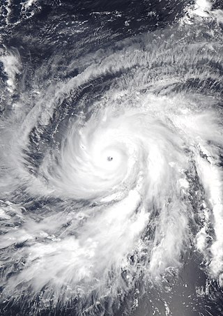
Hurricane Iselle was the strongest tropical cyclone to make landfall on the island of Hawaii in recorded history. The tenth named storm, fifth hurricane, and fourth major hurricane of the 2014 hurricane season, Iselle developed from an area of disturbed weather southwest of Mexico on July 31, 2014. Assuming a west-northwest course that it would maintain throughout its existence, generally favorable atmospheric conditions allowed for gradual strengthening, with the cyclone attaining hurricane status a day after formation. Continued strengthening progressed for several days up until August 4, when Iselle reached peak intensity with maximum sustained winds of 140 mph (220 km/h) and a minimum barometric pressure of 947 mbar, making it a Category 4 hurricane. Thereafter, Iselle encountered hostile environmental conditions and quickly weakened before making landfall on the Big Island on August 8 as a moderate tropical storm. Its passage over the island disrupted the cyclone, and Iselle later dissipated on August 9.

Hurricane Ana was the second tropical cyclone in 2014 to threaten the U.S. state of Hawaii, after Iselle in August. The twenty-first named storm and fifteenth hurricane of the 2014 Pacific hurricane season, Ana formed from a disturbance that formed in the Central Pacific in mid-October. It rapidly consolidated, and a tropical depression developed by October 13. Aided by favorable conditions, Ana gradually strengthened while moving westward, threatening to pass over the island chain of Hawaii once or several times as indicated by early forecasts. By October 17, it had strengthened to a hurricane south of Hawaii and reached its peak intensity shortly afterwards while also making its closest approach. Afterwards, Ana weakened and began to fluctuate in intensity as it turned to the north and eventually northeast as it rounded a subtropical ridge and interacted with a cold front before becoming a hurricane briefly again on October 25. Ana transitioned into an extratropical cyclone on October 26, and raced across the northwest Pacific before dissipating by October 28 after it came ashore in Western Canada.

Hurricane Darby was a strong tropical cyclone which affected Hawaii as a tropical storm. The fifth named storm of the busy 2016 Pacific hurricane season, Darby originated from a low pressure area that developed in the Eastern Pacific well southwest of Mexico during July 2016. It gained sufficient organization to be declared a tropical depression on July 11, and was upgraded to Tropical Storm Darby the next day. Further intensification ensued, and Darby became a hurricane on July 13. Over the next three days, Darby slowly strengthened to Category 3 status on the Saffir–Simpson scale, becoming a major hurricane. Cool waters and dry air caused Darby to weaken over the next three days, although Darby managed to restrengthen slightly on July 21 before weakening once again as the storm neared Hawaii. Just after midnight on July 24, Darby made landfall on the Big Island. Darby weakened into a remnant low two days later.

The 2019 Pacific hurricane season was an above average season which produced nineteen named storms, most of which were rather weak and short-lived. Only seven hurricanes formed, the fewest since 2010. The season officially began on May 15 in the East Pacific Ocean, and on June 1 in the Central Pacific; they both ended on November 30. These dates conventionally delimit the period of each year when most tropical cyclones form in the Pacific basin. This season was one of the latest-starting Pacific hurricane seasons on record, with the first tropical cyclone, Hurricane Alvin, forming on June 25. The final system, Tropical Depression Twenty-One-E, dissipated on November 18.

The 2022 Pacific hurricane season was a slightly above average hurricane season in the eastern North Pacific basin, with nineteen named storms, ten hurricanes, and four major hurricanes. Two of the storms crossed into the basin from the Atlantic. In the central North Pacific basin, no tropical cyclones formed. The season officially began on May 15 in the eastern Pacific, and on June 1 in the central; both ended on November 30. These dates historically describe the period each year when most tropical cyclogenesis occurs in these regions of the Pacific and are adopted by convention.

Hurricane Hector was a powerful and long-lasting tropical cyclone that traversed the Pacific Ocean during late July and August 2018. Hector was the eighth named storm, fourth hurricane, and third major hurricane of the 2018 Pacific hurricane season. It originated from a disturbance that was located north of South America on July 22. The disturbance tracked westward and entered the eastern Pacific around July 25. It gradually organized over the next several days, becoming a tropical depression at 12:00 UTC on July 31. The system was upgraded into a tropical storm about 12 hours later and received the name Hector. Throughout most of its existence, the cyclone traveled due west or slightly north of west. A favorable environment allowed the fledgling tropical storm to rapidly intensify to its initial peak as a Category 2 hurricane by 18:00 UTC on August 2. Wind shear caused Hector to weaken for a brief period before the storm began to strengthen again. Hector reached Category 3 status by 00:00 UTC on August 4 and went through an eyewall replacement cycle soon after, which caused the intensification to halt. After the replacement cycle, the cyclone continued to organize, developing a well-defined eye surrounded by cold cloud tops.

Hurricane Olivia was a tropical cyclone that impacted Hawaii as a weakening tropical storm in mid-September 2018, causing severe flooding and wind damage. Olivia was the first tropical cyclone to make landfall on Maui and Lanai in recorded history. It was the fifteenth named storm, ninth hurricane, and sixth major hurricane of the 2018 Pacific hurricane season.
Hurricane Walaka was a strong tropical cyclone that brought high surf and a powerful storm surge to the Northwestern Hawaiian Islands. Walaka was the nineteenth named storm, twelfth hurricane, eighth major hurricane, and second Category 5 hurricane of the 2018 Pacific hurricane season.

Hurricane Douglas was a strong tropical cyclone that became the closest passing Pacific hurricane to the island of Oahu on record, surpassing the previous record held by Hurricane Dot in 1959. The eighth tropical cyclone, fifth named storm, first hurricane, and first major hurricane of the 2020 Pacific hurricane season, Douglas originated from a tropical wave which entered the basin in mid-July. Located in favorable conditions, the wave began to organize on July 19. It became a tropical depression on July 20 and a tropical storm the following day. After leveling off as a strong tropical storm due to dry air, Douglas began rapid intensification on July 23, becoming the season's first major hurricane the following day and peaking as a Category 4 hurricane. After moving into the Central Pacific basin, Douglas slowly weakened as it approached Hawaii. The storm later passed north of the main islands as a Category 1 hurricane, passing dangerously close to Oahu and Kauai, causing minimal damage, and resulting in no deaths or injuries. Douglas weakened to tropical storm status on July 28, as it moved away from Hawaii, before degenerating into a remnant low on July 29 and dissipating on the next day.

Hurricane Dora, also known as Typhoon Dora, was a long‑lived and powerful tropical cyclone that tracked across all three North Pacific tropical cyclone basins in August 2023. The fourth named storm, fourth hurricane, and second major hurricane of the 2023 Pacific hurricane season, Dora developed on July 31, from a tropical wave that had crossed over Central America from the North Atlantic, and became a tropical storm early the following day. During August 2–3, the system rapidly intensified to Category 4 strength. The same day, Dora moved into the Central Pacific basin from the East Pacific basin. Dora's annular structure deteriorated, leaving the system susceptible to dry air intrusions, and the hurricane passed south of Johnston Island. Dora weakened to Category 3 strength on the morning of August 10.


