Hurricane Bud (2018)

Last updated

Map key
  Tropical depression (≤38 mph, ≤62 km/h)
  Tropical storm (39–73 mph, 63–118 km/h)
  Category 1 (74–95 mph, 119–153 km/h)
  Category 2 (96–110 mph, 154–177 km/h)
  Category 3 (111–129 mph, 178–208 km/h)
  Category 4 (130–156 mph, 209–251 km/h)
  Category 5 (≥157 mph, ≥252 km/h)
  Unknown
Storm type
Disc Plain black.svg Tropical cyclone
Solid black.svg Subtropical cyclone
ArrowUp.svg Extratropical cyclone, remnant low, tropical disturbance, or monsoon depression

Hurricane Bud started as a tropical wave that moved off Africa's west coast and into the Atlantic Ocean on May 29. During the next week, the wave propagated westward, before moving over northern South America and entering the Eastern Pacific Ocean on June 6. Over the next couple of days, atmospheric convection associated with the system significantly increased, before an area of low pressure developed on June 9. Later that day, the National Hurricane Center (NHC) initiated advisories on the system, as it had developed into a tropical depression, while located about 330 mi (530 km) south of Acapulco, Mexico. [1] Six hours later, the depression intensified into a tropical storm, receiving the name Bud from the NHC, as banding features  significantly elongated, curved bands of rain clouds  wrapped into the system's center. Meanwhile, the storm was steered north-westwards around a high-pressure ridge. [1] [4]

Bud began a period of rapid intensification soon after, amid a favorable environment of very warm sea surface temperatures, high mid-level moisture, and low vertical wind shear. [1] The storm developed a central dense overcast and an eye feature at its mid-levels as it quickly consolidated. [5] [6] By 18:00 UTC on June 10, Bud had strengthened into a Category 1 hurricane as a sporadic eye feature began to emerge on visible satellite imagery. [1] [7] The cyclone became a Category 3 major hurricane around 12:00 UTC on June 11. Bud reached its peak intensity as a Category 4 major hurricane, with maximum sustained winds of 140 mph (230 km/h) and a minimum central pressure of 943 mbar (27.85 inHg) at 00:00 UTC on June 12, while located 200 mi (320 km) southwest of Manzanillo, Mexico. [1] Around this time, the cyclone's eye had warmed and become well-defined, but the central dense overcast had been thinning. [8] The hurricane began to weaken soon after, with the northern eyewall of the storm decaying. [9] Soon after, upwelling and cooler sea surface temperatures caused Bud to rapidly weaken. [10] Around midnight UTC on June 13, the hurricane turned towards the north-northwest as it moved around the southern edge of a mid-level high-pressure system. At the same time, Bud had weakened to a minimal Category 2 hurricane. Its eye had dissipated and convection was decreasing in the northern half of the storm. [1] [11]

Bud weakened to a tropical storm by 12:00 UTC on June 13 as its core continued to decay. [1] [12] [13] The storm's intensity soon leveled off, although convection continued to decrease; the remaining banding features were displaced 85 mi (140 km (87 mi)(165 km) from Bud's center. The storm made landfall in San Jose del Cabo, Baja California Sur, at 02:00 UTC on June 15 as a 45 mph (72 km/h) tropical storm. Although the cyclone had moved over sharply higher sea surface temperatures as it emerged into the Gulf of California about 9 hours later, interaction with the terrain of Baja California Sur and higher wind shear weakened the system further. [1] The remaining convection was located in a region 115 mi (185 km) north of the center. [14] The mid- and low-level circulations of Bud split apart, with the former traveling quickly to the northeast and the latter over the Gulf of California and northwestern Mexico. [15] The storm lost all of its thunderstorm activity and became a post-tropical cyclone around 12:00 UTC on June 15 while located about 140 mi (230 km) south-southwest of Huatabampito, Mexico. The system continued to weaken and opened up into a trough of low-pressure by 00:00 UTC on June 16, about 35 mi (56 km) southwest of Huatabampito. [1] The remnants of Bud continued northward, bringing moisture to the Southwestern United States. [16]

Preparations

Tropical Storm Bud approaching the Baja California Peninsula on June 14 Bud 2018-06-14 2055Z.jpg
Tropical Storm Bud approaching the Baja California Peninsula on June 14

The Government of Mexico issued various tropical cyclone watches and warnings in advance of the storm. A tropical storm warning was issued for the southwestern coast of Mexico from Manzanillo to Cabo Corrientes, Mexico, around 21:00 UTC on June 10. A tropical storm watch and warning were issued from Santa Fe to La Paz, Baja California Sur, on June 13. Additional tropical storm watches were issued at 21:00 UTC on June 14 from La Paz to San Evaristo in Baja California Sur and Altata to Huatabampito along the Sonoran coast. [1] Green and yellow alerts, signifying low and moderate danger, respectively, were issued for portions of Sinaloa on June 15. [17] [18] A yellow alert was issued for Jalisco. [19] A red alert, signifying the maximum level of danger, was issued for the Los Cabos Municipality. [20] An orange alert, meaning high danger, was raised for La Paz Municipality. [21] Red alerts were issued in the State of Mexico for the Iztapalapa and Cuajimalpa districts due to the threat of torrential, flooding rainfall. Six other districts had orange or yellow alerts. [22]

Admiral Vidal Francisco Soberón Sanz of the Mexican Secretariat of the Navy activated the Prevention Phase of the Marine Plan, a military disaster preparation and relief plan, in the Mexican states of Baja California Sur, Colima, Jalisco, Sinaloa, Nayarit, Michoacán, and Guerrero. The port in Lázaro Cárdenas, Michoacán was closed to all naval traffic. Small craft were to remain docked at ports in San Carlos, Baja California Sur; Manzanillo, Colima; Acapulco, Zihuatanejo, and Puerto Marqués, Guerrero; [23] [24] and Mazatlán, Sinaloa. [25] People were given until noon on June 13 to evacuate their ships from Cabo San Lucas to safer ports in other locations. [26] In Baja California Sur, 280 shelters were established with a combined capacity of 83,500 people. [27] Classes were suspended in Los Cabos and La Paz as a precautionary measure. [20] Medical services were provided at shelters in the Los Cabos municipality by the Mexican and state governments. [28] Numerous shelters were set up in Guerrero, where those affected by the storm could receive food and cleaning supplies. [25] In total, 599 shelters were erected in Guerrero, with the ability to hold 150,000 people. [29] At least 20 flights were canceled at the Los Cabos International Airport. [29] Around 150 people were evacuated from coastal regions in Armería. [19] The Carnival Splendor cruise ship, which was heading for Cabo San Lucas, was forced to divert to San Diego, California. [30] [31] At the Marquis Los Cabos hotel in San Jose del Cabo, employees anchored palm trees to the ground, reinforced windows with tarps, and stored outside furniture. [32]

Impact

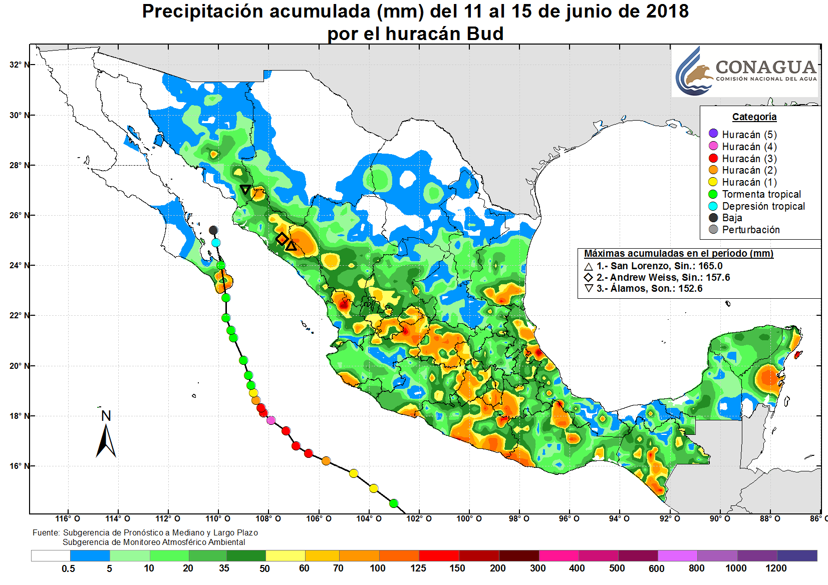
Hurricane Bud produced widespread thunderstorms, causing heavy rainfall across much of Mexico. A peak rainfall total of 6.50 in (165 mm) occurred in San Lorenzo, Sinaloa. Approximately 6.20 in (157.6 mm) of rain was recorded in Andrew Weiss, Sinaloa, and 6.01 in (152.6 mm) fell in Alamos, Sonora. [33]

Jalisco and Colima

Bud caused severe flooding in the state of Jalisco. Rainfall from Bud flooded streets in northern Guadalajara, inundating and/or sweeping away at least 219 vehicles. [34] The Canal de Patria overflowed, flooding streets, as well as the parking lot and first floor of the Plaza Patria mall. [35] People in the mall climbed to higher floors to avoid the flooding. [36] Approximately MX$1,853,000 (US$90,000) of merchandise was damaged and the Marti Sports store suffered over MX$1,000,000 (US$48,500) in infrastructural damage. A RadioShack lost over MX$100,000 (US$4,850) worth of products. Another store suffered MX$500,000 (US$24,250) in lost products. Total damage from the storm in the Plaza Patria mall is unknown. [37] A sinkhole developed at an intersection on Patria Avenue, damaging power lines and traffic lights. The Avila Camacho and Laureles tunnel was closed to traffic after it flooded. [38] At least 94 residences and 27 businesses were damaged by the storm. [34] [35] Water up to 16 ft (5 m) deep completely submerged a light-rail train after an electrical failure prevented the train from reversing. Ninety passengers had to be rescued from the train using lifejackets, surfboards, and boats. [39] [40] [34] Two pumps designed to remove excess water failed due to a power outage. [38] Cleaning operations commenced and one train was removed from the area a day after the flooding occurred; this allowed the station to resume normal traffic. [41] Total damage from the storm in Jalisco was MXN$9.1 million (USD$512,000). [42]

Plan DN-III-E, a disaster relief and rescue plan, was activated in the state by the Secretariat of National Defense (Sedena). Sedena established shelters and performed cleanup operations in the state. [34] The Mexican Army rescued people who had become entrapped in their vehicles. [35] Several people in Zapopán had to swim through floodwaters in the streets and shopping centers to avoid drowning. [43] A person sustained minor injuries as their vehicle was swept away by floodwaters. [36] The person was rescued and transported to a medical facility for treatment. Personnel from the Parks and Gardens department used chainsaws to clear roads after multiple trees fell and blocked them. [41] A federal highway collapsed in the state following heavy rainfall from Bud. [44]

In Colima, waves swept away chairs, tables, and umbrellas from beaches. Twenty-five businesses that were located on El Paraíso beach in Armería were destroyed; 17 more were half destroyed. [19] [45] Debris accumulated on roads in Armería, causing damage. Power grids, as well as hydraulic and drainage systems, sustained damage. At the Pascuales beach in Tecomán, the front street and businesses flooded. [46] In Manzanillo, street flooding occurred and sewer systems were obstructed. Collectively, four trees fell in the towns of Naranjo, Salagua, Santiago, and Nuevo Cuyutlán. [47] Waves flooded shelters and umbrellas at the La Boquita Beach. [46]

Guerrero and Michoacan

In Guerrero, Bud damaged 317 grocery stores, flooded 121 homes in the Grande and Chica regions, and damaged six hotels in Acapulco. At least 12 more homes and 50 shelters were damaged elsewhere in the state. The state provided heavy machinery to use for the cleaning and reconstruction of homes and restaurants that had sustained damage during the storm. [25] The Mexican Army initiated Plan DN-III-E to aid people in the Union of Montes de Oca Municipality. Floodwaters inundated residences in the town of Petalco. Soldiers helped citizens move appliances, mattresses, and pets from their homes. [39] [48] State police and the Mexican Army set up temporary shelters in Tecpan de Galeana and La Unión for 100 people who were forced to evacuate due to heavy rainfall and high waves. [34]

Heavy rainfall from Bud caused the waters of the Laguna Negra of Puerto Marques to become contaminated with sewage, which in turn sparked a die-off of at least four fish species. [49] Beaches and coastal towns were damaged by strong waves and torrential rainfall. Soldiers and local workforces cleaned up the debris from these areas. [44] Businessmen in the resort town of Pie de la Cuesta requested that Fonden, the National Disaster Relief Fund, be activated due to the damage sustained as a result of the storm. Approximately 123 businesses suffered losses and infrastructural damage after strong waves compromised the stability of the sand the buildings were on. The waves swept away furniture and almost killed a family after short-circuiting electrical components. [50] Damages in Guerrero totaled to MXN$100,000 (USD$6,000). [42]

Bud damaged at least 78 businesses along the Jardin, Eréndira, Chuquiapan, Playa Azul, Las Peñas and Caleta beaches in Michoacan. [51] At least 20 palapas, which are open-sided dwellings with thatched roofs made of dried palm leaves, were destroyed at the Jardin and Eréndira beaches. [52] Waves exceeding 13 ft (4 m) and high sea levels damaged the beaches and shelters. Reconstruction work in the area had begun by June 22. [53] Bud washed away the Betula, a Norwegian tanker that had run ashore in 1993; the ship had been a tourist attraction since then. [54] [55] Restaurants located on the beach and homes in Aquila Municipality sustained damage after water from the ocean came 115 ft (35 m) inland. [44] More than sixty homes in the town of Maruata were damaged by floodwaters and winds; the roofs of most were either partially or completely destroyed. People used tarps, plastic sheets, and coconut palm palapas in place of roofs in the months following the storm. A Firm Roof Program was established by the Aquila Municipal Government in the months after Bud to completely cover the costs of replacing all the roofs. The entirety of the ramadas on Maruata beach suffered infrastructural damage as a result of the storm. [56]

Elsewhere

Waves produced by Bud flooded several homes in Navolato, Sinaloa, causing one to collapse. A palapa near a housing complex sustained damage. [57] Fourteen people had to be evacuated from their homes due to rising floodwaters. A dam in Culiacán reached maximum capacity, prompting authorities to discharge the excess water. Three people had to be rescued after their vehicle became trapped in a strong water current. [58] Several hectare of chop suey crops in Mocorito spoiled after excessive rainfall. [59]

The De la Olla and San Renovato dams overflowed due to excessive rainfall from Bud, causing extensive road flooding and damage throughout the historical district in Guanajuato City, Guanajuato. [60] [61]

In Mexico City, the Collective Transportation System Metro halted service to several stations on its A-Line after roads flooded. [62] The line was fully operational by June 15 after the water was drained at one location by four stationary sump pumps, four mobile pumps, and two emergency teams. Another point was cleared by eight mobile pumps. [63] Utility trucks helped to rescue metro passengers who were stranded in floods. Torrential rains caused flooding on Ermita Iztapalapa road until Ignacio Zaragoza road, inundating dozens of vehicles and entrapping the passengers. Local authorities rescued people from their vehicles. At the intersection of the two roads, a patch of flooding at least 330 ft (100 m) long and 1 ft (0.3 m) deep occurred after raw sewage overflowed from drains. [22] Heavy rainfall from Bud generated currents that swept away a child who was crossing a road in the city. [64] [29]

Bud left behind mostly minor damage in Baja California Sur. The storm caused multiple landslides and flooding on a highway connecting La Paz and Cabo San Lucas. Multiple power outages occurred in La Paz. A traffic accident occurred during the storm, leaving one person dead and two more injured. The ports of San José del Cabo and Cabo San Lucas were closed on June 15, although airports in these cities had reopened. [65]

The remnants of Bud sent a plume of moisture into the Southwestern United States, bringing much-needed rainfall to the drought-stricken region. Tucson, Arizona, reported its first precipitation since February 28, with 0.17 in (4.3 mm) of rain on June 15. Flash flood watches were issued for parts of New Mexico and southwestern Colorado. [16] Around 2 in (51 mm) of rain fell near Cave Creek, Arizona, generating streams of water that crossed over and blocked roadways. [66] Thunderstorms generated by Bud's remnants produced wind gusts up to 61 mph (98 km/h) at the Taos Regional Airport in New Mexico. [67] Rain from Bud slowed the growth of the 416 Fire in southwestern Colorado and a fire in southern Wyoming. [68] [69]

See also

Notes

  1. A major hurricane is one that ranks at Category 3 or higher on the Saffir–Simpson scale. [3]

Related Research Articles

<span class="mw-page-title-main">2013 Pacific hurricane season</span>

The 2013 Pacific hurricane season was an above average Pacific hurricane season with 21 tropical cyclones forming. Of these, 20 became named storms – 18 in the Eastern Pacific basin, and 2 in the Central Pacific basin. Of the 18 named storms in the east, 9 became hurricanes, with one, Raymond, becoming the season's only major hurricane. In the central, neither named storm became a hurricane. It was also a below-normal season in terms of Accumulated cyclone energy (ACE), as many of its systems were weak and short-lived. The season officially began on May 15 in the Eastern Pacific and started on June 1 in the Central Pacific; both ended on November 30. These dates conventionally delimit the period of each year when most tropical development occurs in these North Pacific basins. The first cyclone, Tropical Storm Alvin, formed on May 15, and the last, Tropical Storm Sonia, dissipated on November 4.

<span class="mw-page-title-main">Tropical Storm Georgette (2010)</span> Pacific tropical storm in 2010

Tropical Storm Georgette was a short-lived tropical storm that struck Baja California Sur in September 2010. Georgette originated from an area of disturbed weather over the eastern Pacific ocean on September 20. The next day, the system was upgraded into a tropical storm a short distance south of Baja California Sur. As the storm moved over the peninsula, it weakened to a tropical depression. It continued north and as such made landfall on mainland Mexico on September 22. Georgette dissipated early the next day while located inland over Sonora. Although officials noted the threat for heavy rainfall across northwest Mexico and Baja California, damage was minimal and no deaths were reported in the country. However, remnant moisture moved into New Mexico, producing flooding that killed one person.

<span class="mw-page-title-main">Hurricane Erick (2013)</span> Category 1 Pacific hurricane in 2013

Hurricane Erick brought moderate impacts to the western coastline of Mexico in July 2013, and was the last of a succession of four Category 1 hurricanes to affect the Pacific coast of Mexico early in the 2013 Pacific hurricane season. The fifth named storm and fourth hurricane of the annual season, Erick originated from a tropical wave that moved off the western coast of Africa on June 18. The wave tracked swiftly westward with little development, emerging into the eastern Pacific on July 1. As a result of favorable environmental conditions, the wave developed into a tropical depression on July 4, and further into Tropical Storm Erick at 0000 UTC on July 5. Steered generally west-northwest, Erick intensified into a Category 1 hurricane and reached its peak intensity with winds of 80 mph (130 km/h) on July 6. Its proximity to land and track over increasingly cooler waters caused the storm to deteriorate into a tropical storm the following day, though it remained at such intensity until degenerating into a remnant low early on July 9. The remnant circulation dissipated a few hours later, southwest of Baja California Sur.

<span class="mw-page-title-main">Hurricane Manuel</span> Category 1 Pacific hurricane in 2013

Hurricane Manuel brought widespread flooding across much of Mexico in September 2013, in conjunction with Hurricane Ingrid. The fifteenth named storm and seventh hurricane of the annual hurricane season, Manuel originated from a strong area of low pressure south of Acapulco on September 13. Within favorable conditions aloft, the storm intensified into a tropical storm as it tracked northward. The following day, Manuel curved westward and strengthened to a point just shy of hurricane intensity before making its first landfall at that intensity on September 15. Due to interaction with land, the tropical storm quickly weakened, and its center dissipated over western Mexico on September 16. However, the storm's remnants continued to track northwestward into the Gulf of California, where they reorganized into a tropical cyclone the next day. Manuel regained tropical storm status on September 18 as it began to curve northeastward. Shortly thereafter, Manuel attained Category 1 hurricane intensity, before making its final landfall just west of Culiacán at peak intensity. Over land, Manuel quickly weakened due to interaction with Mexico's high terrain, and the storm dissipated early on September 20.

<span class="mw-page-title-main">Hurricane Cosme (2013)</span> Category 1 Pacific hurricane in 2013

Hurricane Cosme caused flooding along the Pacific coast of Mexico in June 2013. The third named tropical cyclone of the 2013 Pacific hurricane season, the storm system formed from a tropical wave south of Manzanillo, Colima, on June 23. The cyclone intensified into a tropical storm on June 24, and soon after strengthened into a hurricane on June 25. Early the following day, Cosme attained its peak intensity as a Category 1 hurricane on the Saffir–Simpson scale with maximum sustained winds of 85 mph (140 km/h) and a minimum barometric pressure of 980 mbar. However, Cosme then began to encounter stable air and lower sea surface temperatures, causing the system to weaken to a tropical storm late on June 26. The system continued to weaken and degenerated into a remnant low pressure surface trough about 690 mi (1,110 km) west-southwest of Cabo San Lucas, Mexico, on June 27. The remnants persisted until dissipating well east-southeast of the Hawaiian Islands on July 1.

<span class="mw-page-title-main">Hurricane Odile</span> Category 4 Pacific hurricane in 2014

Hurricane Odile is tied for the most intense landfalling tropical cyclone in the Baja California Peninsula during the satellite era. Sweeping across the peninsula in September 2014, Odile inflicted widespread damage, particularly in the state of Baja California Sur, in addition to causing lesser impacts on the Mexican mainland and Southwestern United States. The precursor to Odile developed into a tropical depression south of Mexico on September 10 and quickly reached tropical storm strength. After meandering for several days, Odile began to track northwestward, intensifying to hurricane status before rapidly reaching its Category 4 hurricane peak intensity on September 14. The cyclone slightly weakened before making landfall near Cabo San Lucas with winds of 125 mph (205 km/h). Odile gradually weakened as it tracked across the length of the Baja California Peninsula, briefly crossing into the Gulf of California before degenerating into a remnant system on September 17. These remnants tracked northeastward across the Southwestern United States before they were no longer identifiable on September 19.

<span class="mw-page-title-main">Hurricane Sandra (2015)</span> Category 4 Pacific hurricane in 2015

Hurricane Sandra was the latest-forming major hurricane in the northeastern Pacific basin, the strongest Pacific hurricane on record in November, and the record eleventh major hurricane of the 2015 Pacific hurricane season. Originating from a tropical wave, Sandra was first classified as a tropical depression on November 23 well south of Mexico. Environmental conditions, including high sea surface temperatures and low wind shear, were highly conducive to intensification and the storm quickly organized. A small central dense overcast developed atop the storm and Sandra reached hurricane status early on November 25 after the consolidation of an eye. Sandra reached its peak intensity as a Category 4 hurricane on the Saffir–Simpson hurricane wind scale with winds of 150 mph (240 km/h) and a pressure of 934 mbar early on November 26. Thereafter, increasing shear degraded the hurricane's structure and weakening ensued. Rapid weakening took place on November 27 and Sandra's circulation became devoid of convection as it diminished to a tropical storm that evening. The cyclone degenerated into a remnant low soon thereafter and ultimately dissipated just off the coast of Sinaloa, Mexico, on November 29.

<span class="mw-page-title-main">Hurricane Newton (2016)</span> Category 1 Pacific hurricane in 2016

Hurricane Newton was the first tropical cyclone to make landfall on the Baja California Peninsula at hurricane strength since Hurricane Odile in 2014. The fifteenth tropical depression, fifteenth named storm and ninth hurricane of the 2016 Pacific hurricane season, Newton formed from a tropical wave to the south of Mexico on September 4, 2016. Moving northwards through an environment conducive for additional development, Newton rapidly strengthened, reaching hurricane strength on the following day. Newton made landfall on the Baja California Peninsula just below peak strength on the same day. Interaction with the mountainous terrain of the peninsula caused some slight weakening, but Newton remained a hurricane till it entered the Gulf of California. Increasing wind shear caused Newton to weaken at a faster pace, and the system made landfall in Sonora late on September 6 as a strong tropical storm. The cyclone continued to rapidly weaken over the rugged terrain of Sonora, and it degenerated into a remnant low just south of the Mexico–United States border on September 7. The remnants of Newton dissipated early on the following day.

<span class="mw-page-title-main">2018 Pacific hurricane season</span>

The 2018 Pacific hurricane season was one of the most active Pacific hurricane seasons on record, producing the highest accumulated cyclone energy value on record in the basin. The season had the fourth-highest number of named storms – 23, tied with 1982. The season also featured eight landfalls, six of which occurred in Mexico. The season officially began on May 15 in the Eastern Pacific, and on June 1 in the Central Pacific; they both ended on November 30. These dates conventionally delimit the period of each year when most tropical cyclones form in the Pacific basin. However, tropical cyclone formation is possible at any time of the year, as illustrated when the first tropical depression formed on May 10, five days prior to the official start of the season.

<span class="mw-page-title-main">Tropical Depression Nineteen-E (2018)</span> Pacific tropical depression in 2018

Tropical Depression Nineteen-E was a weak yet costly tropical cyclone that caused significant flooding throughout Northwestern Mexico and several states within the United States in September 2018. The storm was also the first known tropical cyclone to form over the Gulf of California. Nineteen-E originated from a tropical wave that left the west coast of Africa on August 29 to 30. It continued westward, crossed over Central America, and entered the northeastern Pacific Ocean by September 7. It then meandered to the southwest of Mexico for the next several days as it interacted with a mid-to-upper level trough. The National Hurricane Center (NHC) continued to track the disturbance for the next several days as it traveled northward. A surface trough developed over the Baja California peninsula on September 18. Despite disorganization and having close proximity to land, the disturbance developed into a tropical depression in the Gulf of California on September 19, after having developed a circulation center and more concentrated convection. The system peaked with maximum sustained winds of 35 mph (55 km/h) and a minimum central pressure of 1002 mbar.

<span class="mw-page-title-main">Hurricane Rosa (2018)</span> Category 4 Pacific hurricane

Hurricane Rosa brought widespread flooding to northwestern Mexico and the Southwestern United States in late September 2018, and was the first tropical cyclone to make landfall in Baja California since Nora in 1997. The seventeenth named storm, tenth hurricane, and seventh major hurricane of the 2018 Pacific hurricane season; Rosa originated from an Atlantic tropical wave that crossed the West African coast on September 6. The wave proceeded westward across the Atlantic, traversing Central America before entering the Gulf of Tehuantepec on September 22. There, the weather system acquired cyclonic features and became a tropical storm on September 25. Within a favorable atmosphere, Rosa entered a period of rapid intensification on September 27, peaking as a Category 4 hurricane with maximum sustained winds of 150 mph (240 km/h) a day later. Over the next few days, Rosa turned north and then northeast while steadily weakening, making landfall in Baja California as a tropical depression on October 2. After crossing over into the Gulf of California, the remnant system split apart and merged with an upper-level low off the coast of California by October 3.

<span class="mw-page-title-main">Hurricane Sergio (2018)</span> Category 4 Pacific hurricane

Hurricane Sergio was a powerful and long-lived tropical cyclone that affected the Baja California Peninsula as a tropical storm and caused significant flooding throughout southern Texas in early October 2018. Sergio became the eighth Category 4 hurricane in the East Pacific for 2018, breaking the old record of seven set in 2015. It was the twentieth named storm, eleventh hurricane, and ninth major hurricane of the season.

<span class="mw-page-title-main">Hurricane Willa</span> Category 5 Pacific hurricane in 2018

Hurricane Willa was a powerful tropical cyclone that brought torrential rains and destructive winds to southwestern Mexico, particularly the states of Sinaloa and Nayarit, during late October 2018. It was the twenty-fifth tropical cyclone, twenty-second named storm, thirteenth hurricane, tenth major hurricane, and record-tying third Category 5 hurricane of the 2018 Pacific hurricane season. Willa was the first major hurricane to make landfall in the Mexican state of Sinaloa since Lane in 2006.

<span class="mw-page-title-main">Tropical Storm Ileana (2018)</span> Pacific tropical cyclone

Tropical Storm Ileana was a small tropical cyclone that affected western Mexico in early August 2018, causing deadly flooding. The eleventh tropical cyclone and ninth named storm of the 2018 Pacific hurricane season, Ileana originated from a tropical wave that the National Hurricane Center began monitoring on July 26 as the wave left the west coast of Africa. The wave traveled across the Atlantic Ocean with no thunderstorm activity, before crossing into the Eastern Pacific Ocean early on August 4. Rapidly developing, the disturbance organized into a tropical depression on the evening of the same day. Initially, the depression was well-defined, but it soon degraded due to northerly wind shear. Despite the unfavorable conditions, the system began to strengthen on August 5, becoming Tropical Storm Ileana. A day later, on August 6, Ileana began to develop an eyewall structure as it reached its peak intensity with winds of 65 mph (100 km/h) and a pressure of 998 mbar (29.47 inHg). The storm gradually became intertwined with the nearby Hurricane John; over the next day, the circulation of John disrupted Ileana before ultimately absorbing it on August 7.

<span class="mw-page-title-main">Hurricane Lorena (2019)</span> Category 1 Pacific hurricane in 2019

Hurricane Lorena was a strong Pacific hurricane in September 2019 that brought heavy rainfall, flooding, and mudslides to Southwestern Mexico and the Baja California Peninsula and also brought severe weather to the U.S. state of Arizona. Lorena was the thirteenth named storm and seventh and final hurricane of the 2019 Pacific hurricane season. A tropical wave, originally from the North Atlantic, entered the East Pacific basin on September 16. With increasing thunderstorm development, Lorena formed as a tropical storm on September 17 alongside Tropical Storm Mario. Lorena made its passage northwestward and quickly gained strength before it made landfall as a Category 1 hurricane in Jalisco on September 19. Due to interaction with the mountainous terrain, Lorena weakened back to a tropical storm. After moving into the warm ocean temperatures of the Gulf of California, however, Lorena re-strengthened into a hurricane, and reached its peak intensity with 1-minute sustained winds of 85 mph (137 km/h) and a minimum barometric pressure of 985 millibars (29.1 inHg) Lorena made a second landfall in the Mexican state of Baja California Sur, and quickly weakened thereafter. Lorena weakened to a tropical storm over the Gulf of California, and became a remnant low on September 22, shortly after making landfall in Sonora as a tropical depression. The remnant low moved inland over Mexico, and eventually dissipated inland over Arizona on September 24.

<span class="mw-page-title-main">Tropical Storm Ivo (2019)</span> Pacific tropical storm in 2019

Tropical Storm Ivo was a tropical cyclone that brought heavy rainfall to five states in Mexico, causing severe flooding during August 2019. The tenth tropical cyclone and ninth named storm of the 2019 Pacific hurricane season, Ivo arose from a low-pressure area that spawned south of Guatemala on August 16. The low-pressure system gradually organized over the next several days as it tracked west-northwestward. The system coalesced into a tropical depression early on August 21 and strengthened into Tropical Storm Ivo several hours later. Located within a favorable environment of moist air and warm sea surface temperatures, the cyclone quickly intensified, peaking the next day with 1-minute maximum sustained winds of 70 mph (110 km/h) and a pressure of 990 mbar (29.23 inHg). Increasing wind shear caused the storm's intensification to level off later that day, as the system turned towards the north-northwest. Ivo passed by Clarion Island midday on August 23, generating winds of 60 mph (100 km/h) on the island. Wind shear caused Ivo to significantly degrade in structure and intensity during the next couple of days. Cold sea surface temperatures, as well as dry and stable air, caused the cyclone to degenerate into a remnant low early on August 25. The low meandered over the eastern Pacific before opening up into a trough of low pressure early on August 27.

<span class="mw-page-title-main">Tropical Storm Dolores (2021)</span> Eastern Pacific tropical storm in 2021

Tropical Storm Dolores was a strong tropical storm that made landfall in southwestern Mexico in June 2021. The fourth named storm of the 2021 Pacific hurricane season, Dolores developed from a low-pressure area that formed offshore the Mexican state of Oaxaca on June 16, 2021. The low steadily developed organized deep convection and a closed surface circulation, becoming Tropical Depression Four-E around 06:00 UTC June 18. The depression strengthened into a tropical storm nine hours later and was named Dolores. Gradually approaching the southwestern coast of Mexico, Dolores steadily intensified despite its close proximity to land. The storm reached its peak intensity around 15:00 UTC June 19 with maximum sustained winds of 115 km/h (70 mph) and a minimum barometric pressure of 29.2 inHg (989 mbar), just below hurricane strength. Shortly after reaching this intensity, Dolores made landfall just northwest of Punta San Telmo, near the Colima–Michoacán state border. The storm rapidly weakened as it moved inland over Mexico and dissipated early on June 20 over the state of Zacatecas.

<span class="mw-page-title-main">Hurricane Nora (2021)</span> Category 1 Pacific hurricane in 2021

Hurricane Nora was a large tropical cyclone that caused significant damage across the Pacific Coast of Mexico in late August 2021. The fourteenth named storm and fifth hurricane of the 2021 Pacific hurricane season, Nora was first monitored by the National Hurricane Center (NHC) as an area of low pressure near the coast of Mexico. On August 24, the low organized into tropical depression, but struggled to develop further due to wind shear in its surrounding environment. The depression eventually intensified into a tropical storm and was named Nora as it tracked to the west-northwest. Nora peaked as a strong Category 1 hurricane with maximum sustained winds of 85 miles per hour (140 km/h) on August 28. The storm then grazed the west coast of Mexico and made landfall two separate times, first in the state of Jalisco, followed by neighboring Nayarit. Nora weakened as it interacted with land, dissipating on August 30 just inland of the Mexican coast.

<span class="mw-page-title-main">Hurricane Olaf (2021)</span> Category 2 Pacific hurricane in 2021

Hurricane Olaf was a Category 2 Pacific hurricane that struck the Baja California Peninsula in September 2021. The fifteenth named storm and sixth hurricane of the 2021 Pacific hurricane season, the cyclone formed from an area of low pressure that developed off the southwestern coast of Mexico on September 5, 2021. The disturbance developed within a favorable environment, acquiring more convection and a closed surface circulation. The disturbance developed into Tropical Depression Fifteen-E by 18:00 UTC on September 7. The depression strengthened into a tropical storm and was named Olaf at 12:00 UTC the next day. Olaf quickly strengthened as it moved to the north-northwest, and was upgraded to a hurricane 24 hours after being named. Hurricane Olaf continued to intensify and reached peak intensity while its center was just offshore the southwestern coast of Baja California Sur, with maximum sustained winds of 105 mph (169 km/h) and a minimum barometric pressure of 975 mbar (28.8 inHg). Just after reaching peak intensity, the hurricane made landfall near San José del Cabo. Interaction with the mountainous terrain of the Baja California Peninsula caused Olaf to quickly weaken. It was downgraded to a tropical storm at 12:00 UTC on September 10. The system became devoid of convection later that day and degenerated to a remnant low by 06:00 UTC on September 11.

References

  1. 1 2 3 4 5 6 7 8 9 10 11 Blake, Eric (24 October 2018). Tropical Cyclone Report: Hurricane Bud (PDF) (Report). National Hurricane Center. Archived (PDF) from the original on 16 December 2018. Retrieved 27 November 2020.
  2. National Hurricane Center; Hurricane Research Division; Central Pacific Hurricane Center (April 26, 2024). "The Northeast and North Central Pacific hurricane database 1949–2023". United States National Oceanic and Atmospheric Administration's National Weather Service. Archived from the original on May 29, 2024. A guide on how to read the database is available here. PD-icon.svg This article incorporates text from this source, which is in the public domain.
  3. "Saffir-Simpson Hurricane Wind Scale". National Hurricane Center. Archived from the original on 20 June 2020. Retrieved 22 June 2020.
  4. Avila, Lixion (10 June 2018). Tropical Storm Bud Discussion Number 2 (Report). National Hurricane Center. Archived from the original on 10 January 2020. Retrieved 27 November 2020.
  5. Pasch, Richard (10 June 2018). Tropical Storm Bud Discussion Number 3 (Report). National Hurricane Center. Archived from the original on 10 January 2020. Retrieved 27 November 2020.
  6. Avila, Lixion (10 June 2018). Tropical Storm Bud Discussion Number 4 (Report). National Hurricane Center. Archived from the original on 10 January 2020. Retrieved 27 November 2020.
  7. Avila, Lixion (10 June 2018). Hurricane Bud Discussion Number 5 (Report). National Hurricane Center. Archived from the original on 10 January 2020. Retrieved 27 November 2020.
  8. Berg, Robbie (12 June 2018). Hurricane Bud Discussion Number 10 (Report). National Hurricane Center. Archived from the original on 10 January 2020. Retrieved 27 November 2020.
  9. Stewart, Stacy (12 June 2018). Hurricane Bud Discussion Number 12 (Report). National Hurricane Center. Archived from the original on 10 January 2020. Retrieved 27 November 2020.
  10. Stewart, Stacy (12 June 2018). Hurricane Bud Discussion Number 13 (Report). National Hurricane Center. Archived from the original on 28 October 2020. Retrieved 27 November 2020.
  11. Berg, Robbie (13 June 2018). Hurricane Bud Discussion Number 14 (Report). National Hurricane Center. Archived from the original on 10 January 2020. Retrieved 27 November 2020.
  12. Pasch, Richard (13 June 2018). Hurricane Bud Discussion Number 15 (Report). National Hurricane Center. Archived from the original on 10 January 2020. Retrieved 27 November 2020.
  13. Stewart, Stacy (13 June 2018). Tropical Storm Bud Discussion Number 16 (Report). National Hurricane Center. Archived from the original on 2 November 2020. Retrieved 27 November 2020.
  14. Cangialosi, John; Latto, Andrew (15 June 2018). Tropical Storm Bud Discussion Number 22 (Report). National Hurricane Center. Archived from the original on 28 October 2020. Retrieved 27 November 2020.
  15. Avila, Lixion (15 June 2018). Tropical Storm Bud Discussion Number 23 (Report). National Hurricane Center. Archived from the original on 28 October 2020. Retrieved 27 November 2020.
  16. 1 2 Donegan, Brian (16 June 2018). "Moisture From the Remnants of Bud Is Spreading Needed-Rainfall Into the Southwest". Weather Underground. Archived from the original on 17 June 2018. Retrieved 18 June 2018.
  17. Félix, Alicia (15 June 2018). "AUDIO Emiten alerta Verde y Amarilla en Sonora por tormenta tropical 'Bud'" [Green and Yellow alert issued in Sonora for tropical storm Bud]. Expreso (in Spanish). Archived from the original on 2 February 2019. Retrieved 15 November 2020.
  18. Martínez, Javier Cabrera (12 June 2018). "Mantienen navegación cerrada ante huracán" [Navigation closed before hurricane]. El Universal (Mexico City) (in Spanish). Archived from the original on 25 July 2018. Retrieved 15 November 2020.
  19. 1 2 3 "Alerta en Colima y Jalisco por huracán 'Bud'; se prevén lluvias y oleaje elevado" [Alert in Colima and Jalisco for Hurricane Bud; rains and high waves are expected]. Noticieros Televisa (in Spanish). 11 June 2018. Archived from the original on 15 November 2020. Retrieved 16 November 2020.
  20. 1 2 "Declararon alerta roja en Los Cabos de México ante la llegada de la tormenta tropical Bud" [Red alert declared in Los Cabos de México before the arrival of Tropical Storm Bud] (in Spanish). Infobae. 15 June 2018. Archived from the original on 25 November 2020. Retrieved 25 November 2020.
  21. Rojas, Margarita. "Elevan alerta en La Paz y Los Cabos por tormenta 'Bud'" [Alert raised in La Paz and Los Cabos for storm 'Bud']. Milenio (in Spanish). Archived from the original on 27 November 2020. Retrieved 27 November 2020.
  22. 1 2 "Alerta roja en Iztapalapa y Cuajimalpa por lluvias torrenciales; Línea A suspende servicio" [Red alert in Iztapalapa and Cuajimalpa due to torrential rains; Line A suspends service]. Proceso (in Spanish). 14 June 2018. Archived from the original on 27 November 2020. Retrieved 27 November 2020.
  23. "Con la temporada de huracanes se activa el Plan Marina… ¿sabes en qué consiste?" [With the hurricane season the Marine Plan is activated… do you know what it consists of?] (in Spanish). Revista Espejo. 13 June 2018. Archived from the original on 15 November 2020. Retrieved 12 November 2020.
  24. Briseño, Pedro Zamora (11 June 2018). "Cierran el puerto de Manzanillo por huracán 'Bud'" [Manzanillo port closed due to Hurricane Bud]. Proceso (in Spanish). Archived from the original on 15 November 2020. Retrieved 14 November 2020.
  25. 1 2 3 Rodríguez, Gladys; Cabrera, Javier; Torres, Raúl; Arrieta, Carlos (13 June 2018). "Hay alerta en 7 estados por paso del huracán 'Bud'" [Alert in 7 states for the passage of Hurricane Bud]. El Universal (Mexico City) (in Spanish). Archived from the original on 15 November 2020. Retrieved 12 November 2020.
  26. Tizon, Gerardo Esquerre (13 June 2018). "Inicia resguardo y retiro de embarcaciones en la marina de Cabo San Lucas por huracán 'Bud'" [Protection and removal of vessels begins in the Cabo San Lucas marina due to Hurricane Bud]. Diario El Independiente (in Spanish). Archived from the original on 27 November 2020. Retrieved 27 November 2020.
  27. "Siga en vivo el paso del Huracán Bud por el noroeste de México" [Follow live the passage of Hurricane Bud through northwestern Mexico] (in Spanish). El Tiempo. 14 June 2018. Archived from the original on 15 November 2020. Retrieved 12 November 2020.
  28. Rodriguez, Abril Tejeda (13 June 2018). "Preparada Secretaría De Salud De Baja California Sur Ante Presencia De Bud" [Baja California Sur Secretariat of Health Prepared in the presence of Bud] (in Spanish). El Informante Baja California Sur. Archived from the original on 15 November 2020. Retrieved 12 November 2020.
  29. 1 2 3 "Bud pasa por México sin causar daños, pero lluvias dejan un muerto en la capital" [Bud passes through Mexico without causing damage, but rains leave one dead in the capital]. El Nuevo Diario (in Spanish). 15 June 2018. Archived from the original on 15 November 2020. Retrieved 15 November 2020.
  30. Summers, Alicia (14 June 2018). "Tropical Storm Bud Forces Carnival Cruise Ship to Detour to San Diego". CBS8. Archived from the original on 27 November 2020. Retrieved 27 November 2020.
  31. Foo, Sasha (14 June 2018). "Carnival Splendor diverted to San Diego as Hurricane Bud approaches coast of Puerto Vallarta". Kusi News. Archived from the original on 9 November 2020. Retrieved 27 November 2020.
  32. Williams, Juliet; Orsi, Peter (14 June 2018). "Strong winds from Tropical Storm Bud hit Mexico's Los Cabos". AP News. Associated Press. Archived from the original on 27 November 2020. Retrieved 27 November 2020.
  33. Precipitación acumulada (mm) del 11 al 15 de junio de 2018 por el huracan bud [Accumulated Precipitation (mm) for Hurricane Bud from 11 to 15 June 2018] (Map) (in Spanish). Conagua. Archived from the original on 15 November 2020. Retrieved 12 November 2020.
  34. 1 2 3 4 5 "Huracán Bud deja daños en infraestructura y evacuados en 2 estados mexicanos" [Hurricane Bud leaves infrastructure damage and evacuees in 2 Mexican states]. Agencia EFE (in Spanish). 11 June 2018. Archived from the original on 16 November 2020. Retrieved 15 November 2020.
  35. 1 2 3 Bañuelos, Jonathan (11 June 2018). "Causa tormenta caos en Jalisco" [Storm causes chaos in Jalisco]. El Heraldo de Aguascalientes (in Spanish). Archived from the original on 16 November 2020. Retrieved 16 November 2020.
  36. 1 2 "Inundaciones en Guadalajara por huracán Bud [VIDEO]" [Floods in Guadalajara due to Hurricane Bud [VIDEO]]. Diario de Mexico (in Spanish). Archived from the original on 18 June 2018. Retrieved 25 November 2020.
  37. "Locatarios de Plaza Patria reportan pérdidas millonarias" [Plaza Patria tenants report millions in losses]. UDG TV (in Spanish). 15 June 2018. Archived from the original on 19 June 2018. Retrieved 25 November 2020.
  38. 1 2 "Zapopan y Guadalajara, zonas afectadas por lluvias históricas del domingo" [Zapopan and Guadalajara, areas affected by historic rains on Sunday]. Noticieros Televisa (in Spanish). 12 June 2018. Archived from the original on 30 November 2019. Retrieved 25 November 2020.
  39. 1 2 "Huracán Bud se intensifica y causa fuertes lluvias e inundaciones en México" [Hurricane Bud intensifies and causes heavy rains and flooding in Mexico]. CNN Espanol (in Spanish). 11 June 2018. Archived from the original on 12 June 2018. Retrieved 27 November 2020.
  40. "Dramático rescate a los pasajeros de un tren que quedó atrapado e inundado en México" [Dramatic rescue of passengers from a train that was trapped and flooded in Mexico] (in Spanish). Infobae. 11 June 2018. Archived from the original on 12 June 2018. Retrieved 25 November 2020.
  41. 1 2 "Las lluvias provocan inundación de hasta 4 metros en Tren Ligero de Guadalajara" [Rains cause flooding of up to 4 meters in the Guadalajara Light Train]. Expansion (in Spanish). CNN Español. 11 June 2018. Archived from the original on 12 June 2018. Retrieved 25 November 2020.
  42. 1 2 Franco Vargas, Ernesto; Méndez Estrada, Karla Margarita; Olmedo Santiago, Cristina (2020). "2018 IMPACTO SOCIOECONÓMICO DE LOS PRINCIPALES DESASTRES OCURRIDOS EN LA REPÚBLICA MEXICANA" (PDF). cenapred.unam.mx. Retrieved July 11, 2024.
  43. Patiño, Daniela (12 June 2018). "Las lluvias del huracán Bud dejan bajo el agua un tren ligero en México" [Hurricane Bud rains submerge light rail in Mexico]. Expansion (in Spanish). CNN Español. Archived from the original on 16 November 2020. Retrieved 15 November 2020.
  44. 1 2 3 "Huracán Bud deja afectaciones menores en cuatro estados del país" [Hurricane Bud leaves minor impacts in four states of the country]. UDG TV (in Spanish). 12 June 2018. Archived from the original on 27 November 2020. Retrieved 25 November 2020.
  45. "Cerrado acceso a Playa El Paraíso ante cercanía de Huracán Bud: PC" [Access to El Paraíso Beach closed due to the proximity of Hurricane Bud: PC]. Colima Noticias (in Spanish). 11 June 2018. Archived from the original on 8 August 2020. Retrieved 24 November 2020.
  46. 1 2 "La playa El Paraíso fue la más afectada por el paso del huracán Bud: PC Colima" [El Paraíso beach was the most affected by the passage of Hurricane Bud: PC Colima]. Colima Noticias (in Spanish). 13 June 2018. Archived from the original on 20 June 2018. Retrieved 24 November 2020.
  47. Moreno, Norma Osiris (12 June 2018). "Afectaciones menores, dejó 'Bud' en Manzanillo: PC Municipal" [Bud left minor affectations in Manzanillo: Municipal PC]. Colima Noticias (in Spanish). Archived from the original on 20 June 2018. Retrieved 24 November 2020.
  48. "Aplican Plan DN-III-E para afectados por el huracán 'Bud' en Guerrero" [DN-III-E Plan is applied for those affected by Hurricane Bud in Guerrero]. Noticieros Televisa (in Spanish). 11 June 2018. Archived from the original on 26 October 2020. Retrieved 25 November 2020.
  49. Memije, Javier Tinoco (13 June 2018). "Denuncian alta mortandad de peces en la Laguna Negra de Puerto Marqués" [High mortality of fish denounced in the Black Lagoon of Puerto Marqués]. El Sol de Acapulco (in Spanish). Archived from the original on 25 November 2020. Retrieved 25 November 2020.
  50. Memije, Javier Tinoco (12 June 2018). "Empresarios de Pie de la Cuesta piden apoyo y activación del Fonden" [Pie de la Cuesta businessmen ask for support and the activation of Fonden]. El Sol de Acapulco (in Spanish). Archived from the original on 27 November 2020. Retrieved 25 November 2020.
  51. "'Bud' causa daños en playas de Lázaro Cárdenas, Michoacán" [Bud causes damage to the beaches of Lázaro Cárdenas, Michoacán]. Noticieros Televisa (in Spanish). 13 June 2018. Archived from the original on 15 November 2020. Retrieved 14 November 2020.
  52. "Daña Huracán Bud Palapas en Playas de Lázaro Cárdenas" [Hurricane Bud damages palapas in Playas de Lázaro Cárdenas]. Primer Plano (in Spanish). 14 June 2018. Archived from the original on 19 June 2018. Retrieved 27 November 2020.
  53. "Realizan limpieza en playas de Michoacán tras paso de 'Bud'" [They clean up the beaches of Michoacán after Bud's passage]. Noticieros Televisa (in Spanish). 22 June 2018. Archived from the original on 15 November 2020. Retrieved 14 November 2020.
  54. "Huracán Bud se lleva consigo a 'El Betula' en Lázaro Cárdenas, Michoacán" [Hurricane Bud takes the El Betula with him in Lázaro Cárdenas, Michoacán]. Monitor Expresso (in Spanish). 11 June 2018. Archived from the original on 15 November 2020. Retrieved 14 November 2020.
  55. "Huracán Bud se lleva restos del barco 'Betula' en Michoacán" [Hurricane Bud takes the remains of the ship Betula in Michoacán]. Noticieros Televisa (in Spanish). 11 June 2018. Archived from the original on 15 November 2020. Retrieved 14 November 2020.
  56. Méndez, Ángel (4 November 2018). "Apoyan con techos firmes a viviendas de Aquila" [They support Aquila homes with firm roofs]. Quadratín (in Spanish). Retrieved 27 November 2020.
  57. Martínez, Javier Cabrera (14 June 2018). "Reportan afectaciones leves por paso de 'Bud' en Sinaloa" [They report slight affectations due to the passage of Bud in Sinaloa]. El Universal (Mexico City) (in Spanish). Archived from the original on 16 November 2020. Retrieved 15 November 2020.
  58. "Tormenta 'Bud' derriba casa en Navolato, Sinaloa" [Storm Bud knocks down house in Navolato, Sinaloa]. Noticieros Televisa (in Spanish). 16 June 2018. Archived from the original on 15 November 2020. Retrieved 14 November 2020.
  59. Villa, Bardo (16 June 2018). "Precipitaciones afectan cultivos de chop suey en Rosamorada" [Rainfall affects chop suey crops in Rosamorada]. Debate (in Spanish). Archived from the original on 17 June 2018. Retrieved 25 November 2020.
  60. "Las lluvias provocan desbordamiento de dos presas en Guanajuato" [The rains cause two dams to overflow in Guanajuato]. Expansion (in Spanish). 13 June 2018. Archived from the original on 15 November 2020. Retrieved 14 November 2020.
  61. "Fuertes lluvias provocadas por Bud desbordan una presa en Guanajuato" [Heavy rains caused by Bud overflow a dam in Guanajuato]. CNN Espanol (in Spanish). 14 June 2018. Archived from the original on 21 September 2020. Retrieved 27 November 2020.
  62. "Deja 'Bud' desborde de presa, alto oleaje y suspensión de clases" [Bud causes a dam overflow, high swells, and the suspension of classes]. La Silla Rota (in Spanish). 14 June 2018. Archived from the original on 15 November 2020. Retrieved 14 November 2020.
  63. "Restablece su servicio la Linea A del metro" [Metro Line A restores its service]. Diario Basta (in Spanish). 15 June 2018. Archived from the original on 25 November 2020. Retrieved 25 November 2020.
  64. "Las lluvias provocan la muerte de un menor en la Ciudad de México" [The rains cause the death of a minor in Mexico City]. Expansion (in Spanish). CNN Español. 15 June 2018. Archived from the original on 31 March 2019. Retrieved 31 March 2019.
  65. "Evalúan daños tras paso de 'Bud' en Baja California Sur" [Damage is assessed after the passage of Bud in Baja California Sur]. Noticieros Televisa (in Spanish). 15 June 2018. Archived from the original on 15 November 2020. Retrieved 27 November 2020.
  66. Event: Flash Flood in Maricopa, Arizona [2018-06-16 15:00 MST-7] (Report). Storm Events Database. National Centers for Environmental Information. Archived from the original on 2020-11-15. Retrieved 12 November 2020.
  67. Event: Thunderstorm Wind in Taos, New Mexico [2018-06-14 16:31 MST-7] (Report). Storm Events Database. National Centers for Environmental Information. Archived from the original on 2020-11-15. Retrieved 12 November 2020.
  68. "Hurricane Bud Leftovers Sweep Helpful Rain Over Colorado, Wyoming Wildfires". Colorado Public Radio. Associated Press. 18 June 2018. Archived from the original on 17 December 2018. Retrieved 16 December 2018.
  69. Semadeni, Alex (16 June 2018). "'It's the perfect kind of rain'". The Durango Herald. Archived from the original on 17 December 2018. Retrieved 16 December 2018.
Hurricane Bud
Bud 2018-06-12 0000Z.jpg
Bud at peak intensity while off the coast of Mexico on June 11