Hurricane Rosa (2018)

Last updated
Map key
  Tropical depression (≤38 mph, ≤62 km/h)
  Tropical storm (39–73 mph, 63–118 km/h)
  Category 1 (74–95 mph, 119–153 km/h)
  Category 2 (96–110 mph, 154–177 km/h)
  Category 3 (111–129 mph, 178–208 km/h)
  Category 4 (130–156 mph, 209–251 km/h)
  Category 5 (≥157 mph, ≥252 km/h)
  Unknown
Storm type
Disc Plain black.svg Tropical cyclone
Solid black.svg Subtropical cyclone
ArrowUp.svg Extratropical cyclone, remnant low, tropical disturbance, or monsoon depression

Hurricane Rosa originated from a vigorous tropical wave that departed from the west coast of Africa on September 6. The wave traveled across the tropical Atlantic with minimal associated convection and became difficult to track after interacting with a mid-level trough in the Caribbean Sea. [1] The National Hurricane Center (NHC) issued a Tropical Weather Outlook on September 19, anticipating that an area of low pressure would form in the Gulf of Tehuantepec over the weekend. [2] The wave crossed Central America and entered the gulf on September 22, where it produced a surface circulation with convective activity aloft. [1] Though broad in structure, the system consolidated as it proceeded slightly north of west. [3] [4] It was officially classified as Tropical Depression Twenty-E on September 25, at 06:00 UTC, located 350 mi (560 km) south-southwest of Manzanillo, Mexico. [1]

At the time of its formation, the depression was located within a favorable tropospheric environment of warm sea surface temperatures and minimal vertical wind shear, featuring a well-defined center of circulation under an expanding area of strong convection. [5] The depression maintained a trend of steady strengthening over the 24 hours: it was upgraded to Tropical Storm Rosa six hours after being classified, [1] and became the tenth hurricane of the season a day later, at 12:00 UTC on September 26. [1] [6] The NHC remarked that Rosa's structure was well developed at the middle levels of the troposphere, with distinct rainbands wrapped around the southern semicircle of the cyclone. [7] The hurricane leveled in intensity for eighteen hours before proceeding into another phase of rapid intensification; [1] it reached major hurricane status at 18:00 UTC on September 27, peaking in intensity with maximum sustained winds of 150 mph (240 km/h) and a minimum central pressure of 936 mbar (27.6 inHg). This made Rosa the seventh Category 4 hurricane of the year's season. [1] [8]

After Rosa reached its peak, the hurricane's eyewall – an inner ring of clouds around the eye, marked by high winds – began to warm considerably, signaling the start of an eyewall replacement cycle. [9] Rosa turned to the northwest on the afternoon of September 28 in response to an approaching mid- to upper-level trough, which would continue to influence the remainder of the hurricane's development. [10] Now tracking over cooler seas, Rosa steadily weakened down to Category 2  by 00:00 UTC, September 29, while undergoing its eyewall replacement. [11] Once the replacement cycle was completed, the storm briefly restrengthened because of its much-improved structure, with expanding outflow to the northeast of the eye. [1] [12] However, Rosa began to experience impinging wind shear from the developing trough, causing a misalignment between the upper and lower levels of the hurricane, [13] as well as coinciding with a final weakening phase. [1] [13]

Rosa turned to the north on September 29, ahead of the trough. [12] The unrelenting wind shear – combined with progressively cooler seas and drier air – quickly eroded Rosa's core, disrupting the eye and convection over the southern half of the hurricane. [14] [15] At 12:00 UTC on September 30, the diminishing hurricane dropped to Category 1 while being steered towards the northeast between the trough and a subtropical ridge. [1] [16] Rosa lost its hurricane status twelve hours later, proceeding towards the Baja California Peninsula as a tropical storm. [1] It further weakened to a tropical depression on October 2, after the convection became displaced from the elongating center. [17] At 11:00 UTC on October 2, Rosa made landfall about 70 mi (110 km) southeast of Punta San Antonio in Baja California, [1] becoming the first tropical cyclone to move over the state since Nora of 1997. [18] [19] During its approach towards the Gulf of California, Rosa exhibited an increasingly unwound and diffuse structure, prompting the NHC to declassify it as a tropical cyclone at 15:00 UTC. [20] Shortly after, forecasters at the Weather Prediction Center (WPC) noted that the low- and mid-level circulations of Rosa's remnant had decoupled; the mid-level remnants proceeded into northeast Arizona, while the lower segment traced behind it over the Gulf of California. [21] On October 3, in their final advisory on the system, the WPC reported that the remnants had been absorbed into a deepening non-tropical low off the coast of California. [22]

Preparations, impact, and aftermath

Mexico

Hurricane Rosa approaching the Baja California Peninsula on September 29 Rosa 2018-09-29 2045Z.jpg
Hurricane Rosa approaching the Baja California Peninsula on September 29

The Government of Mexico issued a tropical storm watch on September 29 for the Pacific Coast of the Baja California Peninsula from Punta Abreojos to Cabo San Quintín. The watches on the west coast of Baja California were changed to tropical storm warnings, and watches were issued for the east coast of Baja California from Bahía de los Angeles to San Felipe on the next day. All the watches and warnings were discontinued after Rosa weakened to a tropical depression. [1] The State Unit of Civil Protection of Sonora issued a yellow alert (imminent severe weather) for 11 municipalities and a green alert (possible severe weather) for 19 municipalities on September 30. [23] A red alert was issued for San Felipe on October 1 as Rosa approached Baja California. [24] On the same day, schools were closed in several communities throughout Baja California as well as in the neighboring state of Sonora. [25] The Marine Plan, an evacuation and rescue plan, was activated in the states of Baja California, Baja California Sur, Sonora, and Sinaloa. [26]

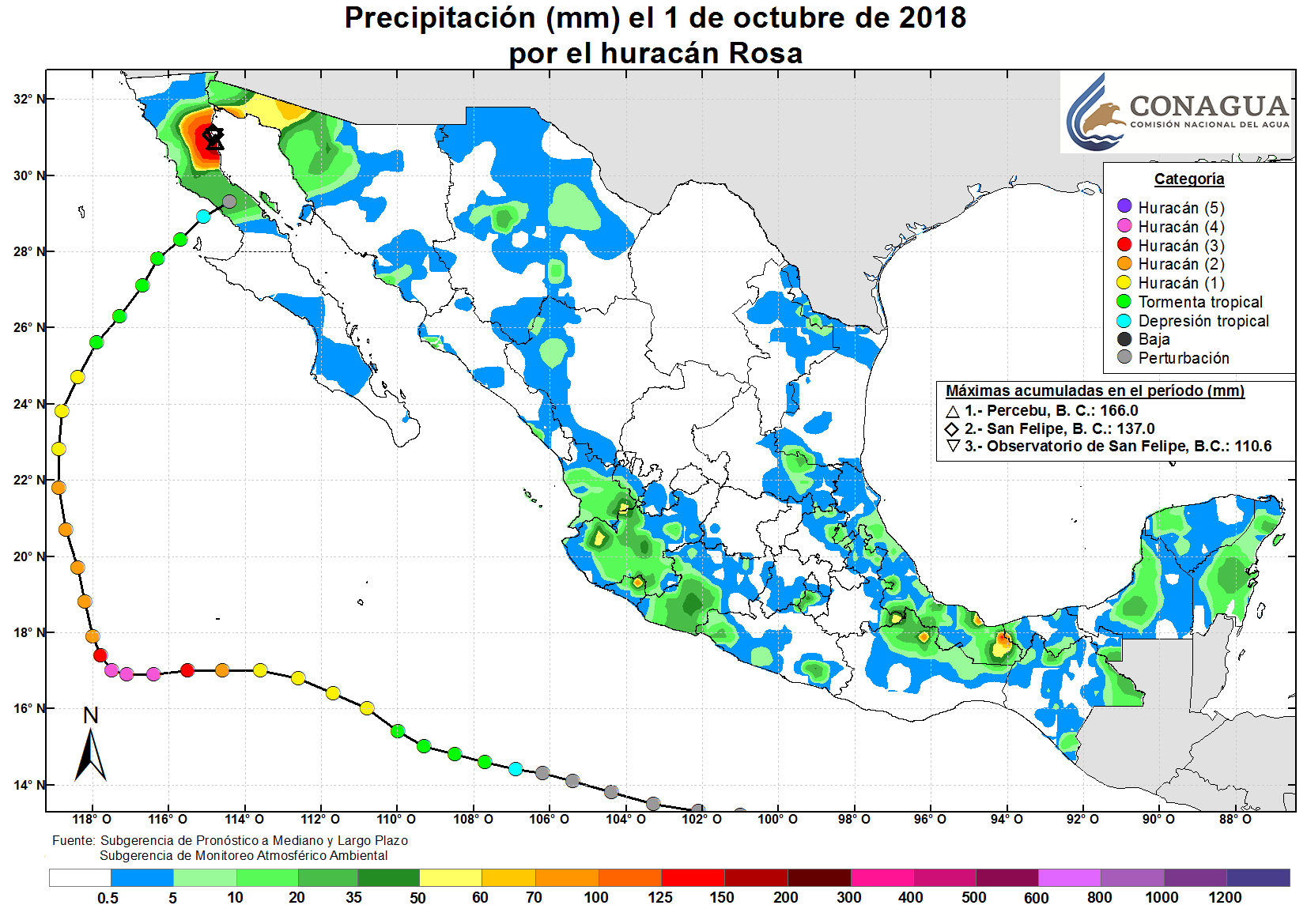
Because of its significant weakening before landfall, Rosa had a relatively minor impact in Mexico. [1] Rainfall was heaviest in Baja California, peaking at 6.54 in (166 mm) in Percebu and at 5.39 in (137 mm) in San Felipe. [27] A rainfall total of 2.6 in (67 mm) occurred in Sonoyta, Sonora, near the US-Mexico border. [28] Floods in San Felipe collapsed part of a highway and opened up a sinkhole in the city's port. [29] [24] The port suffered MX$10 million (US$530,000) in losses following a five-day shutdown of its operations. [30] Rosa caused widespread coastal flooding near San Felipe and damaged archaeological sites. [31] In Los Cabos, Baja California Sur, rainstorms triggered power outages and floods swept away vehicles. [32] In Puerto Peñasco, Sonora, dozens of homes and businesses suffered from flooding after an estimated 4 in (100 mm) of rain fell. Many of the town's roads were closed, and four bridges became impassable. [33] A woman drowned in Caborca, Sonora, after being swept away by floodwaters. [34]

Farther south, in the state of Colima, floodwaters swept through the city of Manzanillo, causing sinkholes, rupturing underground pipes, and inundating buildings. Landslides in and around the city blocked roads and buried three vehicles in mud. [35] Throughout the state of Michoacán, the combined effects from Rosa and nearby Tropical Storm Sergio destroyed 86,000 acres (35,000 ha) of crops. [36] After Rosa's passage, states of emergency were issued for the cities of Ensenada, Mexicali, [25] and Puerto Peñasco. [33]

United States

Rainfall totals for the second round of rain generated by Rosa's remnants, which lasted from October 1-2. Hurricane Rosa (2018) rainfall.png
Rainfall totals for the second round of rain generated by Rosa's remnants, which lasted from October 1–2.

Exiting the Gulf of California, the remnants of Rosa tracked northward, spawning showers and thunderstorms in the Four Corners region. [37] Damage from flooding in the Southwestern United States totaled about $50 million (USD). [38] [39] Flood watches and warnings were issued on September 30 for Southern California, Arizona, southwest Colorado, Utah, central Nevada, and a small portion of southeast Idaho. [40] Rosa dropped 5.9 in (150 mm) of rain on a two week old, 240 sq mi (610 km2) burn scar in central Utah. Samples taken from streams that received rainfall from Rosa showed that the wildfires had lowered the level of carbon, nitrogen, and phosphorus. [41] [42] [43] On October 1, an interaction between Rosa's remnants and a Pacific low produced severe thunderstorms in San Bernardino County, California. [44] Surging floodwaters carried rocks onto portions of U.S. Route 95 and coated parts of state routes 62 and 127 in mud and debris. [34] [44] [45] Effects from the severe weather extended into Nevada, where flash floods inundated buildings and deposited rubble along Pioche's Main Street. [46]

By the time of Rosa's absorption on October 3, a total of 6.89 in (175 mm) of rain was recorded at Towers Mountain, Arizona, located about 85 mi (137 km) north of Phoenix; other areas throughout the state reported up to 5.5 in (140 mm) of rain. [22] The remnants of Rosa caused flash floods throughout the communities of Guadalupe, Glendale, Scottsdale, Fountain Hills, Deer Valley, and Sun City [47] and knocked out power in Yuma. [34] As rainfall exceeded 2 in (50 mm), the National Weather Service issued a flash flood warning for the Phoenix area. Though over two dozen roads, as well as schools and businesses, had been closed, 80 car accidents occurred during the torrential rains. [48] Outside the Phoenix area, weather-related traffic accidents resulted in the deaths of a 26-year-old woman just north of Cameron and a 34-year-old man in Kingman. [49] [50]

At Menagers Dam near Sells, Arizona, rainfall from Rosa brought the water level within 1 foot (0.30 m) of maximum capacity on October 2, raising concerns about the dam's structural integrity. [51] Saying dam failure was imminent, the National Weather Service in Tucson urged residents of Ali Chuk to evacuate immediately. [52] Later that day, 162 people were evacuated from Ali Chuk, as well as 32 from Kohatk and 23 from the Menagers Dam community. [51] Engineers were recruited to carry out assessments of the dam, [53] and authorities continued to monitor the water level for two weeks before allowing residents to return to their homes on October 17. [54] Water discharge rates on the Salt River reached 25,000 cu ft (710 m3) per second, requiring officials to release water from the Tempe Town Lake. [55]

The Federal Highway Administration announced on September 10, 2019, that it was providing $4.7 million to the state of Arizona to fund road and bridge repairs required as a result of Rosa. [56] Road crews worked to repair a hillside along Arizona State Route 87 that was compromised as a result of heavy rainfall during Rosa. The project involved cleaning ditches, creating new ditches, removing landslide material, depositing boulders to prevent erosion, and repairing pavement; the cost was pegged at $4.2 million. [57]

See also

Related Research Articles

<span class="mw-page-title-main">Hurricane Nora (1997)</span> Category 4 Pacific hurricane in 1997

Hurricane Nora was the first tropical cyclone to enter the Continental United States from the Pacific Ocean since Hurricane Lester in 1992. Nora was the fourteenth named tropical cyclone and the seventh hurricane of the 1997 Pacific hurricane season. The September storm formed off the Pacific coast of Mexico, and aided by waters warmed by the 1997–98 El Niño event, eventually peaked at Category 4 intensity on the Saffir–Simpson hurricane scale.

<span class="mw-page-title-main">Hurricane Kathleen</span> Category 1 Pacific hurricane in 1976

Hurricane Kathleen was a tropical cyclone that had a destructive impact in California. On September 7, 1976, a tropical depression formed; two days later it accelerated north towards the Baja California Peninsula. Kathleen brushed the Pacific coast of the peninsula as a hurricane on September 9 and made landfall as a fast-moving tropical storm the next day. With its circulation intact and still a tropical storm, Kathleen headed north into the United States and affected California and Arizona. Kathleen finally dissipated late on September 11.

<span class="mw-page-title-main">Hurricane Marty (2003)</span> Category 2 Pacific hurricane in 2003

Hurricane Marty was a Category 2 Pacific hurricane that caused extensive flooding and damage in northwestern Mexico just weeks after Hurricane Ignacio took a similar course. Marty was the thirteenth named storm, fourth hurricane, and the deadliest tropical cyclone of the 2003 Pacific hurricane season. Forming on September 18, it became the 13th tropical storm and fourth hurricane of the year. The storm moved generally northwestward and steadily intensified despite only a marginally favorable environment for development, and became a Category 2 hurricane before making two landfalls on the Baja California peninsula and mainland Mexico.

<span class="mw-page-title-main">Hurricane Lester (1992)</span> Category 1 Pacific hurricane in 1992

Hurricane Lester was the first Pacific tropical cyclone to enter the United States as a tropical storm since 1967. The fourteenth named storm and eighth hurricane of the 1992 Pacific hurricane season, Lester formed on August 20 from a tropical wave southwest of Mexico. The tropical storm moved generally northwestward while steadily intensifying. After turning to the north, approaching the Mexican coast, Lester attained hurricane status. The hurricane reached peak winds of 85 mph (137 km/h) before making landfall on west-central Baja California. The system weakened while moving across the peninsula and then over northwestern Mexico. Not long after entering Arizona, Lester weakened to a tropical depression, and degenerated into an extratropical low on August 24, 1992, over New Mexico. The storm's remnants later merged with the remnants of Hurricane Andrew and another frontal system on August 29.

<span class="mw-page-title-main">Hurricane Raymond (1989)</span> Category 4 Pacific hurricane in 1989

Hurricane Raymond was the strongest tropical cyclone of the 1989 Pacific hurricane season, peaking as a strong Category 4 hurricane on the Saffir–Simpson hurricane scale. Forming out of a tropical wave on September 25, 1989, the tropical depression slowly tracked northwest before becoming nearly stationary the next day. Shortly after, the depression intensified into Tropical Storm Raymond and took a general westward track. Gradually intensifying, Raymond attained hurricane-status on September 28 and attained its peak intensity on September 30, with winds of 145 mph (233 km/h) and a barometric pressure of 935 mbar. Steady weakening then took place and by October 3, Raymond turned northeast towards land. The storm continued to weaken as it accelerated and eventually made landfall on the Baja California Peninsula as a tropical storm late on October 4 and a second landfall in Sonora, Mexico. Shortly after, Raymond weakened to a depression as it tracked inland. The remnants of the system persisted until October 7 when it dissipated over the Central United States.

<span class="mw-page-title-main">Hurricane Jimena (2009)</span> Category 4 Pacific hurricane in 2009

Hurricane Jimena is tied with Hurricane Norbert as the strongest tropical cyclone to make landfall on western portion of the Baja California Peninsula. Jimena was the twelfth named storm, fifth hurricane, third major hurricane and overall second-strongest tropical cyclone of the 2009 Pacific hurricane season. Forming from a tropical wave late on August 28, 2009, off of Mexico's Pacific coast, the system rapidly intensified into a Category 2 hurricane on the next day. Two days after developing, Jimena strengthened into a Category 4 hurricane. After peaking close to Category 5 intensity on September 1, it encountered cold water and began to weaken. When the hurricane made landfall on the Baja California Peninsula on September 3, it was only a Category 2 hurricane. On the next day, the tropical cyclone entered the Gulf of California, though the storm weakened into a remnant low after looping back eastward towards Baja California. The storm's remnants drifted westward into the Pacific afterward, before dissipating on September 8.

<span class="mw-page-title-main">2015 Pacific hurricane season</span> Hurricane season in the Pacific Ocean

The 2015 Pacific hurricane season is the second-most active Pacific hurricane season on record, with 26 named storms, only behind the 1992 season. A record-tying 16 of those storms became hurricanes, and a record 11 storms further intensified into major hurricanes throughout the season. The Central Pacific, the portion of the Northeast Pacific Ocean between the International Date Line and the 140th meridian west, had its most active year on record, with 16 tropical cyclones forming in or entering the basin. Moreover, the season was the third-most active season in terms of accumulated cyclone energy, amassing a total of 290 units. The season officially started on May 15 in the Eastern Pacific and on June 1 in the Central Pacific; they both ended on November 30. These dates conventionally delimit the period of each year when most tropical cyclones form in the Northeast Pacific basin. However, the formation of tropical cyclones is possible at any time of the year. This was shown when a tropical depression formed on December 31. The above-average activity during the season was attributed in part to the very strong 2014–16 El Niño event.

<span class="mw-page-title-main">Hurricane Norbert (1984)</span> Category 4 Pacific hurricane in 1984

Hurricane Norbert marked the first time a core of a hurricane was fully mapped in three-dimensions. First forming on September 14, 1984 west of the Mexican coast, Norbert gradually intensified, reaching hurricane intensity two days after formation. On September 22, Norbert peaked in strength as a Category 4 hurricane on the Saffir-Simpson Hurricane Scale. While intensifying, Norbert meandered. It moved east, then north, then west, then south, then back towards the east, and finally towards the northeast. After fluctuating in intensity for two more days, Norbert rapidly weakened. It turned towards the northwest and made landfall in southern Baja California Norte as a tropical storm. The combination of Norbert and several other storms left thousands homeless throughout Mexico. The remnants of Hurricane Norbert produced moderate rain over Arizona.

<span class="mw-page-title-main">Hurricane Joanne (1972)</span> Category 2 Pacific hurricane in 1972

Hurricane Joanne was one of four tropical cyclones to bring gale-force winds to the Southwestern United States in the 20th century. A tropical depression developed on September 30, 1972. It then moved west northwest and intensified into a hurricane on October 1. Hurricane Joanne peaked as a Category 2 hurricane, as measured by the modern Saffir-Simpson hurricane wind scale (SSHWS), October 2. Joanne then slowed and began to re-curve. Joanne made landfall along the northern portion of the Baja California Peninsula as a tropical storm. The tropical storm moved inland over Sonora on October 6 and was believed to have survived into Arizona as a tropical storm. In Arizona, many roads were closed and some water rescues had to be performed due to a prolonged period of heavy rains. One person was reportedly killed while another was electrocuted. A few weeks after the hurricane, Arizona would sustain additional flooding and eight additional deaths.

<span class="mw-page-title-main">Hurricane Odile</span> Category 4 Pacific hurricane in 2014

Hurricane Odile is tied for the most intense landfalling tropical cyclone in the Baja California Peninsula during the satellite era. Sweeping across the peninsula in September 2014, Odile inflicted widespread damage, particularly in the state of Baja California Sur, in addition to causing lesser impacts on the Mexican mainland and Southwestern United States. The precursor to Odile developed into a tropical depression south of Mexico on September 10 and quickly reached tropical storm strength. After meandering for several days, Odile began to track northwestward, intensifying to hurricane status before rapidly reaching its Category 4 hurricane peak intensity on September 14. The cyclone slightly weakened before making landfall near Cabo San Lucas with winds of 125 mph (205 km/h). Odile gradually weakened as it tracked across the length of the Baja California Peninsula, briefly crossing into the Gulf of California before degenerating into a remnant system on September 17. These remnants tracked northeastward across the Southwestern United States before they were no longer identifiable on September 19.

<span class="mw-page-title-main">Hurricane Blanca (2015)</span> Pacific hurricane in 2015

Hurricane Blanca in 2015 was the earliest recorded tropical cyclone to make landfall on the Baja California Peninsula. Forming as a tropical depression on May 31, Blanca initially struggled to organize due to strong wind shear. However, once this abated, the system took advantage of high sea surface temperatures and ample moisture. After becoming a tropical storm on June 1, Blanca rapidly intensified on June 2–3, becoming a powerful Category 4 hurricane on the Saffir–Simpson hurricane wind scale; maximum sustained winds reached 145 mph (230 km/h) at this time. The hurricane's slow motion resulted in tremendous upwelling of cooler water, resulting in a period of weakening. Blanca gradually recovered from this and briefly regained Category 4 status on June 6 as it moved generally northwest toward the Baja California peninsula. Cooler waters and increased shear again prompted weakening on June 7 and the system struck Baja California Sur on June 8 as a weak tropical storm. It quickly degraded to a depression and dissipated early the next day.

<span class="mw-page-title-main">Hurricane Linda (2015)</span> Category 3 pacific hurricane in 2015

Hurricane Linda was a strong tropical cyclone in September 2015 that resulted in heavy rains across portions of Mexico and the Southwestern United States. The seventeenth named storm, eleventh hurricane, and eighth major hurricane of the season, Linda developed southwest of Mexico from a low-pressure area on September 5. Under warm sea surface temperatures and low to moderate wind shear, the system intensified into Tropical Storm Linda by September 6 and a hurricane by the next day. A well-defined eye soon formed within the storm's central dense overcast and Linda reached its peak intensity as a 125 mph (205 km/h) Category 3 major hurricane on the Saffir–Simpson hurricane wind scale on September 8. Thereafter, the storm moved into a stable environment and an area of lower sea surface temperatures, causing rapid weakening. Convective activity dissipated and Linda degenerated into a remnant low on September 10. The lingering system persisted southwest of Baja California, ultimately opening up into a trough on September 14.

<span class="mw-page-title-main">Tropical Storm Lidia (2017)</span> Pacific tropical storm

Tropical Storm Lidia was a large tropical cyclone that caused flooding in Baja California Peninsula and parts of western Mexico. The fourteenth tropical cyclone and twelfth named storm of the 2017 Pacific hurricane season, Lidia developed from a large area of disturbed weather west of the Pacific Coast of Mexico on August 31. The storm intensified while moving generally northward or northwestward, peaking with maximum sustained winds of 65 mph (105 km/h) later that day. On September 1, Lidia made landfall in Mexico near Puerto Chale, Baja California Sur, at peak intensity. The storm weakened while traversing the peninsula, ultimately emerging over the Pacific Ocean on September 3, where the storm degenerated into a remnant low. The system brought thunderstorms and wind gusts to Southern California, before dissipating on September 4.

<span class="mw-page-title-main">2018 Pacific hurricane season</span> Hurricane season in the Pacific Ocean

The 2018 Pacific hurricane season was one of the most active Pacific hurricane seasons on record, producing the highest accumulated cyclone energy value on record in the basin. The season had the fourth-highest number of named storms – 23, tied with 1982. The season also featured eight landfalls, six of which occurred in Mexico. The season officially began on May 15 in the Eastern Pacific, and on June 1 in the Central Pacific; they both ended on November 30. These dates conventionally delimit the period of each year when most tropical cyclones form in the Pacific basin. However, tropical cyclone formation is possible at any time of the year, as illustrated when the first tropical depression formed on May 10, five days prior to the official start of the season.

<span class="mw-page-title-main">Tropical Depression Nineteen-E (2018)</span> Pacific tropical depression in 2018

Tropical Depression Nineteen-E was a weak yet costly tropical cyclone that caused significant flooding throughout Northwestern Mexico and several states within the United States in September 2018. The storm was also the first known tropical cyclone to form over the Gulf of California. Nineteen-E originated from a tropical wave that left the west coast of Africa on August 29 to 30. It continued westward, crossed over Central America, and entered the northeastern Pacific Ocean by September 7. It then meandered to the southwest of Mexico for the next several days as it interacted with a mid-to-upper level trough. The National Hurricane Center (NHC) continued to track the disturbance for the next several days as it traveled northward. A surface trough developed over the Baja California peninsula on September 18. Despite disorganization and having close proximity to land, the disturbance developed into a tropical depression in the Gulf of California on September 19, after having developed a circulation center and more concentrated convection. The system peaked with maximum sustained winds of 35 mph (55 km/h) and a minimum central pressure of 1002 mbar.

<span class="mw-page-title-main">Hurricane Sergio (2018)</span> Category 4 Pacific hurricane

Hurricane Sergio was a powerful and long-lived tropical cyclone that affected the Baja California Peninsula as a tropical storm and caused significant flooding throughout southern Texas in early October 2018. Sergio became the eighth Category 4 hurricane in the East Pacific for 2018, breaking the old record of seven set in 2015. It was the twentieth named storm, eleventh hurricane, and ninth major hurricane of the season.

<span class="mw-page-title-main">Hurricane Lorena (2019)</span> Category 1 Pacific hurricane in 2019

Hurricane Lorena was a strong Pacific hurricane in September 2019 that brought heavy rainfall, flooding, and mudslides to Southwestern Mexico and the Baja California Peninsula and also brought severe weather to the U.S. state of Arizona. Lorena was the thirteenth named storm and seventh and final hurricane of the 2019 Pacific hurricane season. A tropical wave, originally from the North Atlantic, entered the East Pacific basin on September 16. With increasing thunderstorm development, Lorena formed as a tropical storm on September 17 alongside Tropical Storm Mario. Lorena made its passage northwestward and quickly gained strength before it made landfall as a Category 1 hurricane in Jalisco on September 19. Due to interaction with the mountainous terrain, Lorena weakened back to a tropical storm. After moving into the warm ocean temperatures of the Gulf of California, however, Lorena re-strengthened into a hurricane, and reached its peak intensity with 1-minute sustained winds of 85 mph (137 km/h) and a minimum barometric pressure of 985 millibars (29.1 inHg) Lorena made a second landfall in the Mexican state of Baja California Sur, and quickly weakened thereafter. Lorena weakened to a tropical storm over the Gulf of California, and became a remnant low on September 22, shortly after making landfall in Sonora as a tropical depression. The remnant low moved inland over Mexico, and eventually dissipated inland over Arizona on September 24.

<span class="mw-page-title-main">Hurricane Dolores (2015)</span> Category 4 Pacific hurricane in 2015

Hurricane Dolores was a powerful and moderately damaging tropical cyclone whose remnants brought record-breaking heavy rains and strong winds to California. The seventh named storm, fourth hurricane, and third major hurricane of the record-breaking 2015 Pacific hurricane season, Dolores formed from a tropical wave on July 11. The system gradually strengthened, attaining hurricane status on July 13. Dolores rapidly intensified as it neared the Baja California peninsula, finally peaking as a Category 4 hurricane on the Saffir–Simpson scale with winds of 130 mph (215 km/h) on July 15. An eyewall replacement cycle began and cooler sea-surface temperatures rapidly weakened the hurricane, and Dolores weakened to a tropical storm two days later. On July 18, Dolores degenerated into a remnant low west of the Baja California peninsula.

References

  1. 1 2 3 4 5 6 7 8 9 10 11 12 13 14 15 Avila, Lixion A. (January 30, 2019). Tropical Cyclone Report: Hurricane Rosa (PDF) (Report). National Hurricane Center. Retrieved January 30, 2019.
  2. Blake, Eric (September 19, 2018). Tropical Weather Outlook [20:48 UTC, Wed Sep 19, 2018] (Report). NHC Graphical Outlook Archive. National Hurricane Center. Archived from the original on September 28, 2018. Retrieved September 26, 2018.
  3. Zelinsky, David (September 22, 2018). Tropical Weather Outlook [23:24 UTC, Sat Sep 22, 2018] (Report). NHC Graphical Outlook Archive. National Hurricane Center. Archived from the original on September 28, 2018. Retrieved September 26, 2018.
  4. Zelinsky, David (September 24, 2018). Tropical Weather Outlook [23:24 UTC, Mon Sep 24, 2018] (Report). NHC Graphical Outlook Archive. National Hurricane Center. Archived from the original on September 30, 2018. Retrieved September 26, 2018.
  5. Cangialosi, John (September 25, 2018). Tropical Depression Twenty-E Discussion Number 1 (Report). National Hurricane Center. Archived from the original on January 31, 2019. Retrieved January 30, 2019.
  6. Roberts, Dave (September 26, 2018). Hurricane Rosa Advisory Number 6 (Report). National Hurricane Center. Archived from the original on September 28, 2018. Retrieved September 27, 2018.
  7. Roberts, Dave (September 26, 2018). Hurricane Rosa Discussion Number 6 (Report). National Hurricane Center. Archived from the original on February 1, 2019. Retrieved January 31, 2019.
  8. Blake, Eric (September 28, 2018). Hurricane Rosa Discussion Number 12 (Report). National Hurricane Center. Archived from the original on November 5, 2018. Retrieved September 29, 2018.
  9. Roberts, Dave (September 28, 2018). Hurricane Rosa Discussion Number 13 (Report). National Hurricane Center. Archived from the original on February 1, 2019. Retrieved January 31, 2019.
  10. Zelinsky, David (September 28, 2018). Hurricane Rosa Discussion Number 14...Corrected (Report). National Hurricane Center. Archived from the original on September 30, 2018. Retrieved September 29, 2018.
  11. Blake, Eric (September 29, 2018). Hurricane Rosa Discussion Number 16 (Report). National Hurricane Center. Archived from the original on September 30, 2018. Retrieved September 29, 2018.
  12. 1 2 Beven, Jack (September 29, 2018). Hurricane Rosa Discussion Number 18 (Report). National Hurricane Center. Archived from the original on September 30, 2018. Retrieved September 29, 2018.
  13. 1 2 Stewart, Stacy (September 29, 2018). Hurricane Rosa Discussion Number 17 (Report). National Hurricane Center. Archived from the original on October 1, 2018. Retrieved January 31, 2019.
  14. Stewart, Stacy (September 30, 2018). Hurricane Rosa Discussion Number 21 (Report). National Hurricane Center. Archived from the original on September 30, 2018. Retrieved September 30, 2018.
  15. Pasch, Richard (September 30, 2018). Hurricane Rosa Discussion Number 22 (Report). National Hurricane Center. Archived from the original on September 30, 2018. Retrieved September 30, 2018.
  16. Stewart, Stacy (September 30, 2018). Hurricane Rosa Discussion Number 20 (Report). National Hurricane Center. Archived from the original on October 10, 2021. Retrieved July 11, 2019.
  17. Brown, Daniel (October 2, 2018). Tropical Depression Rosa Discussion Number 29 (Report). National Hurricane Center. Archived from the original on October 3, 2018. Retrieved October 2, 2018.
  18. Johnson, Weldon B. (September 27, 2018). "Rosa is out there. Has a hurricane ever hit Arizona?". The Arizona Republic. Archived from the original on October 6, 2021. Retrieved July 2, 2019.
  19. Cappucci, Matthew (October 1, 2018). "Southwest braces for Rosa's torrential rains". The Mercury News. Archived from the original on July 2, 2019. Retrieved July 2, 2019.
  20. Cangialosi, John (October 2, 2018). Remnants of Rosa Advisory Number 30 (Report). National Hurricane Center. Archived from the original on October 3, 2018. Retrieved October 2, 2018.
  21. Otto, Richard (October 2, 2018). Storm Summary Number 5 for Heavy Rainfall Associated with Rosa (Report). Weather Prediction Center. Archived from the original on February 3, 2019. Retrieved October 2, 2018.
  22. 1 2 Kong, Kwan-Yin (October 3, 2018). Storm Summary Number 7 for Heavy Rainfall Associated with Rosa (Report). Weather Prediction Center. Archived from the original on February 3, 2019. Retrieved October 3, 2018.
  23. "Emiten alerta por llegada de 'Rosa' a Sonora y Baja California". Lopez-Doriga (in Spanish). September 30, 2018. Archived from the original on June 4, 2019. Retrieved June 4, 2019.
  24. 1 2 "Sigue alerta en Puerto de San Felipe por remanentes de 'Rosa'". Televisa News (in Spanish). October 2, 2018. Archived from the original on December 2, 2020. Retrieved June 5, 2019.
  25. 1 2 Orsi, Peter; Tang, Terry (October 1, 2018). "Tropical Storm Rosa Heads for Baja, US Southwest". U.S. News & World Report. Associated Press. Archived from the original on October 2, 2018. Retrieved October 2, 2018.
  26. "Activan Plan Marina por el poderoso huracán "Rosa" que amenaza a México". El Imparcial (in Spanish). September 28, 2018. Archived from the original on June 5, 2019. Retrieved June 5, 2019.
  27. "Precipitación acumulada (mm) el 1 de octubre de 2018 por el huracan Rosa" (Map). gob.mx (in Spanish). Conagua. Archived from the original on August 19, 2020. Retrieved March 12, 2019.
  28. Rodríguez Castañeda, José Luis; Lagunes, Alejandro Jiménez; Murillo, Ricardo Sánchez; Adams, David; Quezadas, Juan Pérez (January 2021). "Isotopic variability (δ18O, δ2H and d-excess) during rainfall events of the north American monsoon across the Sonora River Basin, Mexico". Journal of South American Earth Sciences. Science Direct. 105: 6. Bibcode:2021JSAES.10502928Q. doi:10.1016/j.jsames.2020.102928. S2CID   225139701. Archived from the original on 2021-12-11. Retrieved 2021-12-28.
  29. "Colapsa vialidad en San Felipe por intensa lluvia". Uniradio Noticias (in Spanish). October 1, 2018. Archived from the original on August 19, 2020. Retrieved June 4, 2019.
  30. Campos, Diana (October 3, 2018). "10 millones de pérdidas en San Felipe por lluvias" (in Spanish). Cadena Noticias. Archived from the original on October 23, 2018. Retrieved October 23, 2018.
  31. Vellanoweth, René L.; Porcayo-Michelini, Antonio; Guttenberg, Richard B.; Hayden, William; Ainis, Amira F.; Hernández-Estrada, Raquel L. (16 July 2020). "Spring tides, storm surges, and the destruction of coastal middens: A case study from the upper Gulf of California, México". The Journal of Island and Coastal Archaeology. Taylor & Francis Online. 16 (3): 3. doi:10.1080/15564894.2020.1782539. S2CID   225541774. Archived from the original on 15 January 2022. Retrieved 21 January 2022.
  32. "Las lluvias de 'Rosa' provocan inundaciones en Los Cabos". La Prensa (in Spanish). September 28, 2018. Archived from the original on September 29, 2018. Retrieved June 5, 2019.
  33. 1 2 Hernández, Tania Yamileth (October 3, 2018). "Declaran emergencia en Puerto Peñasco por "Rosa"". El Imparcial (in Spanish). Archived from the original on October 25, 2018. Retrieved October 25, 2018.
  34. 1 2 3 Wright, Pam (October 5, 2018). "At Least 2 Dead in Arizona, 1 in Mexico Following Flash Flooding From Rosa's Remnants". The Weather Channel. Archived from the original on October 3, 2018. Retrieved July 15, 2019. person reportedly drowned in Mexico after being swept away by floodwaters.
  35. "Lluvias dejan afectaciones en La Central, en Manzanillo, Colima". Televisa News (in Spanish). September 27, 2018. Archived from the original on October 10, 2021. Retrieved June 5, 2019.
  36. "Al menos 35.000 hectáreas de cultivo afectadas en México por fuertes lluvias". NTN 24 (in Spanish). September 30, 2018. Archived from the original on June 5, 2019. Retrieved June 5, 2019.
  37. October 2018 Climate Summary for Eastern Utah and Western Colorado (Report). National Weather Service. Archived from the original on February 23, 2019. Retrieved February 23, 2019.
  38. Weather, Climate & Catastrophe Insight – 2018 Annual Report (PDF) (Report). Aon Benfield. January 22, 2019. Archived (PDF) from the original on February 14, 2019. Retrieved January 24, 2019.
  39. Hanson, Aprille (4 March 2019). "Casa Digna restores dignity through housing, employment". Arkansas Catholic. Archived from the original on 15 January 2022. Retrieved 21 January 2022.
  40. Tate, Jennifer (October 1, 2018). Storm Summary Number 1 for Heavy Rainfall Associated with Rosa...Corrected (Report). Weather Prediction Center. Archived from the original on February 3, 2019. Retrieved October 2, 2018.
  41. Crandall, Trevor; Jones, Erin; Greenhalgh, Mitchell; Frei, Rebecca J.; Griffin, Natasha; Severe, Emilee; Maxwell, Jordan; Patch, Leika; St. Clair, S. Isaac; Bratsman, Sam; Merritt, Marina; Norris, Adam J.; Carling, Gregory T.; Hansen, Neil; St. Clair, Samuel B.; Abbott, Benjamin W. (23 September 2021). "Megafire affects stream sediment flux and dissolved organic matter reactivity, but land use dominates nutrient dynamics in semiarid watersheds". PLOS ONE. 16 (9): e0257733. Bibcode:2021PLoSO..1657733C. doi: 10.1371/journal.pone.0257733 . PMC   8460006 . PMID   34555099.
  42. Crandall, Trevor (26 March 2019). Wildfires and Storm Events: Multiple Stressors Alter Stream Form and Function in Semi-Arid Watersheds (Report). Utah State University. Archived from the original on 15 January 2022. Retrieved 21 January 2022.
  43. Crandall, Trevor (27 March 2020). Wildfire in the West: How Megafires and Storm Events Affect Stream Chemistry and Nutrient Dynamics in Semi-Arid Watersheds (Report). Brigham Young University. ISSN   2572-4479. Archived from the original on 15 January 2022. Retrieved 21 January 2022.
  44. 1 2 Event: Flash Flood in San Bernardino, CA [2018-10-03, 17:08 PST-8] (Report). Storm Events Database. National Centers for Environmental Information. Archived from the original on February 24, 2019. Retrieved February 24, 2019.
  45. Event: Flash Flood in San Bernardino, CA [2018-10-03, 16:29 PST-8] (Report). Storm Events Database. National Centers for Environmental Information. Archived from the original on February 24, 2019. Retrieved February 24, 2019.
  46. Event: Flash Flood in Lincoln, NV [2018-10-03, 11:15 PST-8] (Report). Storm Events Database. National Centers for Environmental Information. Archived from the original on February 25, 2019. Retrieved February 24, 2019.
  47. Event: Flash Flood in Maricopa, AZ [2018-10-02, 10:00 MST-7] (Report). Storm Events Database. National Centers for Environmental Information. Archived from the original on February 24, 2019. Retrieved February 24, 2019.
  48. "'One of the rainiest days': Streets flooded, schools closed as Rosa takes toll on Arizona". 13wmaz. October 2, 2018. Archived from the original on August 19, 2020. Retrieved February 23, 2019.
  49. Devereaux, Katie (October 5, 2018). "One dead after part of Highway 89 washed out". Arizona Daily Sun. Archived from the original on October 6, 2018. Retrieved October 6, 2018.
  50. Holler, Madeleine (October 5, 2018). "MCSO: One dead in Kingman after flash flood". AZFamily. Archived from the original on October 11, 2018. Retrieved October 11, 2018.
  51. 1 2 "Southern Arizona dam holding as water recedes". New Haven Register. Associated Press. October 3, 2018. Archived from the original on October 5, 2018. Retrieved October 5, 2018.
  52. NWS Tucson [@NWSTucson] (October 2, 2018). "Dam failure is imminent at Menegers Lake on the Tohono O'odham Nation. Evacuation per authorities is strongly advised for the village of Ali Chuk. #azwx" (Tweet). Retrieved October 5, 2018 via Twitter.
  53. Duarte, Carmen; Knott, Gloria (October 4, 2018). "Water levels drop, but tribal officials remain concerned Arizona dam could fail". Arizona Daily Star. Archived from the original on October 4, 2018. Retrieved October 5, 2018.
  54. Radwany, Sam (October 17, 2018). "Some Tohono O'odham Nation evacuees finally returning home". Kgun 9. ABC. Archived from the original on August 19, 2020. Retrieved June 18, 2019.
  55. Goldstein, Steve; Gilger, Lauren; Johnson, Nakiesha; Hernandez, Julian (25 September 2019). "Soggy Weather Has Much Of Arizona Under Flash Flood Watches". KJZZ. Associated Press. Archived from the original on 15 January 2022. Retrieved 21 January 2022.
  56. "Tennessee to get $190 million in emergency relief funds for road and bridge repairs". WRCB Channel 3 News. 10 September 2019. Archived from the original on 5 March 2020. Retrieved 21 January 2022.
  57. Bechman, Alexis (23 March 2021). "$4 million landslide stabilization project ongoing on State Route 87". Payson Roundup. Archived from the original on 23 March 2021. Retrieved 21 January 2022.
Hurricane Rosa
Rosa 2018-09-28 0945Z.jpg
Hurricane Rosa at peak intensity southwest of Baja California Sur on September 28

PD-icon.svg This article incorporates public domain material from websites or documents of the National Weather Service .