Tropical storm (39–73 mph, 63–118 km/h)
Category 1 (74–95 mph, 119–153 km/h)
Category 2 (96–110 mph, 154–177 km/h)
Category 3 (111–129 mph, 178–208 km/h)
Category 4 (130–156 mph, 209–251 km/h)
Category 5 (≥157 mph, ≥252 km/h)
Unknown
A tropical wave moved off the coast of Africa on June 3. It tracked westward across the unfavorable Atlantic Ocean, and on June 15 it crossed Central America into the eastern Pacific Ocean. The system continued westward, and late on June 16 a low pressure area developed about 300 miles (480 km) southwest of San José, Costa Rica. At around 1200 UTC on June 17, Dvorak classifications began on the disturbance, though initially its convection was broadly distributed and disorganized. The next day, however, an area of concentrated convection developed just south of the Gulf of Tehuantepec. [1] Ships in the vicinity confirmed the development of a surface circulation within the system, while satellite imagery showed the development of a central dense overcast. [2] Based on its organization, it is estimated the system developed into Tropical Depression Three-E late on June 18 while located about 270 miles (430 km) southeast of Puerto Angel, Oaxaca in Mexico. [1]
Initially, the convection of the depression was displaced to the west of the circulation due to some easterly wind shear, though as it tracked west-northwestward parallel to the coast of Mexico, it maintained and developed deep convection near and over the center. [3] With favorable conditions, the cyclone strengthened and became Tropical Storm Carlotta early on June 19. The storm initially maintained a track toward the Mexican coastline, though a mid-level ridge turned it to the west; its closest point of approach was about 140 miles (230 km) at 1200 UTC on June 19. [1] Late that day, a ragged banding-eye feature developed on satellite imagery, while at the same time it maintained an area of strong convection and well-defined outflow to its south. [4] The storm continued to intensify, and at 0600 UTC on June 20 Carlotta attained hurricane status while located about 155 miles (249 km) south of Acapulco. [1] Operationally, it was upgraded to hurricane status six hours earlier. [5]
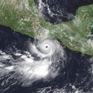
With a large anticyclone centered near Mazatlán, Sinaloa, Carlotta turned more to the west. Deep convection increased in coverage and intensity [6] as the system maintained impressive upper-level outflow over its southern semicircle. Late on June 20, Hurricane Carlotta began a period of rapid deepening, [1] with warm waters and a very favorable upper-level environment, [7] and in a twelve-hour period the pressure dropped 49 mbar to an estimated minimum central pressure of 932 mbar at 0600 UTC on June 21; at the same time, Carlotta attained peak winds of 155 mph (249 km/h) while located about 285 miles (459 km) southwest of Acapulco. [1] At the time of its peak intensity, Carlotta maintained a well-defined central dense overcast around an eye of 20 miles (32 km) in diameter. Satellite intensity estimates indicated winds of 160 mph (260 km/h), [7] though through much of its duration there was a sizable discrepancy between the estimated winds and that of winds reported by Hurricane Hunters. [1]
Hurricane Carlotta maintained peak winds for about twelve hours before weakening as it curved around the periphery of the mid-level ridge over Mexico. [1] Late on June 21, the eye had become less distinct while its surrounding ring of convection eroded and warmed. [8] Early on June 22, northeasterly wind shear increased, [9] and shortly thereafter the weakening trend was temporarily halted with some oscillations in the convective intensity and eye definition. Weakening continued on June 23 as the hurricane tracked over increasingly cooler waters, and shortly after 0000 UTC on June 24 Carlotta weakened to a tropical storm about 260 miles (420 km) west-southwest of Cabo San Lucas. Overall convection continued to diminish, and early on June 25 the winds dropped to tropical depression status. Deep convection ceased to exist by 0600 UTC on June 25, and Carlotta degenerated into a remnant low pressure area. The low-level circulation of Carlotta persisted for several days as it continued northwestward. [1]
Impact

Shortly after first developing, the government of Mexico issued a tropical storm warning from Salina Cruz to Acapulco, and later was extended to Zihuatanejo. Though the National Hurricane Center never forecast it to make landfall, one computer model predicted Carlotta to move ashore; due to the threat, the Mexican government also issued a hurricane watch from Puerto Angel to Zihuatanejo. [1] Outer rainbands and rough surf affected the southwestern coast of Mexico for an extended duration; [10] officials evacuated about 100 families in potentially flooded areas of Acapulco as a precaution. [11] Precipitation and clouds were reported in every Mexican state along the Pacific Ocean, [12] resulting in flooding in some areas. [13] No stations in Mexico reported sustained tropical storm force winds; however, Bahías de Huatulco International Airport in Oaxaca reported a wind gust of 44 mph (71 km/h). [1] Heavy rainfall and rough seas were also reported on Socorro Island. [12]
Seven ships reported tropical storm force winds in association with Carlotta, peaking at 46 mph (74 km/h); the lowest pressure recorded by ship was 1,008 mbar. [1] Offshore, waves reached 40 feet (12 m) in height. [14] The Lithuanian freighter Linkuva, en route to Long Beach, California, encountered the waves and strong winds as the hurricane was undergoing its period of rapid intensification. After an engine failure, the freighter was lost about 220 miles (350 km) southwest of Acapulco. [1] A naval vessel from both the United States Navy and the Mexican Navy searched for the freighter for three days, [14] though the crew was lost and presumed killed. [15]
See also
Related Research Articles

The 1991 Atlantic hurricane season was the first season since 1984 in which no hurricanes developed from tropical waves, which are the source for most North Atlantic tropical cyclones. The hurricane season officially began on June 1, and ended on November 30. It was the least active in four years due to higher than usual wind shear across the Atlantic Ocean. The first storm, Ana, developed on July 2 off the southeast United States and dissipated without causing significant effects. Two other tropical storms in the season – Danny and Erika – did not significantly affect land. Danny dissipated east of the Lesser Antilles, and Erika passed through the Azores before becoming extratropical. In addition, there were four non-developing tropical depressions. The second depression of the season struck Mexico with significant accompanying rains.
The 2001 Pacific hurricane season was a relatively near-average Pacific hurricane season which produced sixteen named storms, though most were rather weak and short-lived including one unnamed tropical storm which was operationally recognized as a tropical depression, the first such occurrence since 1996. Only eight hurricanes formed and two major hurricanes. The season officially began on May 15 in the East Pacific Ocean, and on June 1 in the Central Pacific; they ended on November 30. These dates conventionally delimit the period of each year when most tropical cyclones form in the Pacific basin. However, the formation of tropical cyclones is possible at any time of the year.

The 2000 Pacific hurricane season was an above-average Pacific hurricane season, although most of the storms were weak and short-lived. There were few notable storms this year. Tropical storms Miriam, Norman, and Rosa all made landfall in Mexico with minimal impact. Hurricane Daniel briefly threatened the U.S. state of Hawaii while weakening. Hurricane Carlotta was the strongest storm of the year and the second-strongest June hurricane in recorded history. Carlotta killed 18 people when it sank a freighter. Overall, the season was significantly more active than the previous season, with 19 tropical storms. In addition, six hurricanes developed. Furthermore, there were total of two major hurricanes.

The 1999 Pacific hurricane season was one of the least active Pacific hurricane seasons on record. The season officially began on May 15 in the Eastern Pacific, and on June 1 in the Central Pacific; in both basins, it ended on November 30. These dates conventionally delimit the period during which most tropical cyclones form in the northeastern Pacific Ocean. The first tropical cyclone of the season, Hurricane Adrian, developed on June 18, while the final storm of the season, Tropical Storm Irwin, dissipated on October 11. No storms developed in the Central Pacific during the season. However, two storms from the Eastern Pacific, Dora and Eugene, entered the basin, with the former entering as a hurricane.

The 1988 Pacific hurricane season was the least active Pacific hurricane season since 1981. It officially began May 15, in the eastern Pacific, and June 1, in the central Pacific and lasted until November 30. These dates conventionally delimit the period of each year when most tropical cyclones form in the northeastern Pacific Ocean. The first named storm, Tropical Storm Aletta, formed on June 16, and the last-named storm, Tropical Storm Miriam, was previously named Hurricane Joan in the Atlantic Ocean before crossing Central America and re-emerging in the eastern Pacific; Miriam continued westward and dissipated on November 2.

The 2007 Pacific hurricane season was a below-average Pacific hurricane season, featuring one major hurricane. The season officially started on May 15 in the eastern Pacific and on June 1 in the central Pacific, and ended on November 30; these dates conventionally delimit the period during which most tropical cyclones form in the region. The first tropical cyclone of the season, Alvin, developed on May 27, while the final system of the year, Kiko, dissipated on October 23. Due to unusually strong wind shear, activity fell short of the long-term average, with a total of 11 named storms, 4 hurricanes, and 1 major hurricane. At the time, 2007 featured the second-lowest value of the Accumulated cyclone energy (ACE) index since reliable records began in 1971. Two tropical cyclones – Cosme and Flossie – crossed into the central Pacific basin during the year, activity below the average of 4 to 5 systems.

Hurricane Wilma was the most intense tropical cyclone in the Atlantic basin on record in terms of minimum barometric pressure, with an atmospheric pressure of 882 millibars (26.0 inHg). Wilma's destructive journey began in the second week of October 2005. A large area of disturbed weather developed across much of the Caribbean and gradually organized to the southeast of Jamaica. By late on October 15, the system was sufficiently organized for the National Hurricane Center to designate it as Tropical Depression Twenty-Four.
The meteorological history of Hurricane Ivan, the longest tracked tropical cyclone of the 2004 Atlantic hurricane season, lasted from late August through late September. The hurricane developed from a tropical wave that moved off the coast of Africa on August 31. Tracking westward due to a ridge, favorable conditions allowed it to develop into Tropical Depression Nine on September 2 in the deep tropical Atlantic Ocean. The cyclone gradually intensified until September 5, when it underwent rapid deepening and reached Category 4 status on the Saffir-Simpson Hurricane Scale; at the time Ivan was the southernmost major North Atlantic hurricane on record.

The 2011 Pacific hurricane season was a below average season in terms of named storms, although it had an above average number of hurricanes and major hurricanes. During the season, 13 tropical depressions formed along with 11 tropical storms, 10 hurricanes and 6 major hurricanes. The season officially began on May 15 in the East Pacific Ocean, and on June 1 in the Central Pacific; they both ended on November 30. These dates conventionally delimit the period of each year when most tropical cyclones form in the Pacific basin. The season's first cyclone, Hurricane Adrian formed on June 7, and the last, Hurricane Kenneth, dissipated on November 25.

The 2012 Pacific hurricane season was a moderately active Pacific hurricane season that saw an unusually high number of tropical cyclones pass west of the Baja California Peninsula. The season officially began on May 15 in the eastern Pacific Ocean, and on June 1 in the central Pacific (from 140°W to the International Date Line, north of the equator; they both ended on November 30. These dates conventionally delimit the period of each year when most tropical cyclones form in these regions of the Pacific Ocean. However, the formation of tropical cyclones is possible at any time of the year. This season's first system, Tropical Storm Aletta, formed on May 14, and the last, Tropical Storm Rosa, dissipated on November 3.
Hurricane Lester was a small but powerful tropical cyclone that caused heavy flooding in Central America and southern Mexico in October 1998. Lester was the fifteenth tropical cyclone, twelfth named storm and eighth hurricane of the 1998 Pacific hurricane season. Lester originated from a tropical wave that emerged off the coast of Africa on September 29. Under favorable conditions, the storm was classified as a tropical depression on October 15. The depression was upgraded to a tropical storm later that day and a hurricane on October 16. After undergoing fluctuations in intensity, Lester reached peak winds of 115 mph (185 km/h), a Category 3 hurricane on the Saffir-Simpson Hurricane Scale. After several days, it degenerated into a tropical storm on October 26, and dissipated shortly after. The hurricane made its closest approach to land on October 28, producing moderate winds and heavy rainfall. A mudslide triggered by the precipitation killed two children, although damage is unknown.

The 2008 Pacific hurricane season officially started on May 15 in the East Pacific Ocean, and on June 1 in the Central Pacific; they both ended on November 30. These dates conventionally delimit the period of each year when most tropical cyclones form in the Pacific basin. The first storm of the year, Tropical Storm Alma, developed on May 29, and the last, Tropical Storm Polo dissipated on November 5.[

The 2006 Pacific hurricane season was the first above-average season since 1997 which produced twenty-five tropical cyclones, with nineteen named storms, though most were rather weak and short-lived. Only eleven hurricanes formed and six major hurricanes. Following the inactivity of the previous seasons, forecasters predicted that season would be only slightly above active. It was also the first time since 2003 in which at least one cyclone of tropical storm intensity made landfall. The season officially began on May 15 in the East Pacific Ocean, and on June 1 in the Central Pacific; they ended on November 30. These dates conventionally delimit the period of each year when most tropical cyclones form in the Pacific basin. However, the formation of tropical cyclones is possible at any time of the year.

The 2010 Pacific hurricane season was one of the least active seasons on record, featuring the fewest named storms since 1977. The season officially started on May 15 in the eastern Pacific—east of 140°W—and on June 1 in the central Pacific—between the International Date Line and 140°W—and lasted until November 30. These dates typically cover the period of each year when most tropical cyclones form in the eastern Pacific basin. The season's first storm, Tropical Storm Agatha, developed on May 29; the season's final storm, Tropical Storm Omeka, degenerated on December 21.

Tropical Storm Agatha was the deadliest tropical cyclone to form during the 1992 Pacific hurricane season, killing 10 people as it passed offshore Mexico. The third named storm of the record-breaking season, Agatha developed as a tropical depression off the Pacific coast of Mexico on June 1. The storm gradually organized over the next several hours. As it moved northward, the depression intensified into Tropical Storm Agatha later that day. After reaching its peak winds as a strong tropical storm, Agatha steadily weakened while turning to the west. The system was downgraded to a tropical depression on June 5, and subsequently lost its tropical characteristics the next day. Although Agatha never made landfall, the storm's outer rainbands triggered widespread flooding that killed ten people.
The 2011 Atlantic hurricane season was an event in the annual hurricane season in the north Atlantic Ocean. It was well above average, with 19 tropical storms forming. Even so, it was the first season on record in which the first eight storms failed to attain hurricane strength. The season officially began on June 1, 2011, and ended on November 30, 2011, dates that conventionally delimit the period of each year when most tropical cyclones develop in the Atlantic basin. The season's first storm, Tropical Storm Arlene did not form until June 28. The final storm to develop, Tropical Storm Sean, dissipated on November 11.
The 2012 Pacific hurricane season was an above-average year in which seventeen named storms formed. The hurricane season officially began on May 15 in the east Pacific—defined as the region east of 140°W—and on June 1 in the central Pacific—defined as the region west of 140°W to the International Date Line—and ended on November 30 in both regions. These dates conventionally delimit the period during each year when most tropical cyclones form in the northeastern Pacific Ocean. This year, the first storm of the season, Tropical Storm Aletta, formed on May 14, and the last, Tropical Storm Rosa, dissipated on November 3.

The 2012 Atlantic hurricane season was an event in the annual hurricane season in the north Atlantic Ocean. For the third year in a row there were 19 named storms. The season officially began on June 1, 2012, and ended on November 30, 2012, dates that conventionally delimit the period of each year when most tropical cyclones develop in the Atlantic basin. Surprisingly, two preseason storms formed: Alberto on May 19, and Beryl on May 26. This was the first such occurrence since the 1951 season. The final storm to dissipate was Sandy, on October 29. Altogether, ten storms became hurricanes, of which two intensified into major hurricanes.

The 2013 Pacific hurricane season was an above-average year in which twenty named storms developed. The hurricane season officially began on May 15 in the East Pacific, coinciding with the formation of Tropical Storm Alvin, and on June 1 in the Central Pacific; it ended on November 30 in both basins. These dates conventionally delimit the period during each year when most tropical cyclones form. The final system of the year, Tropical Storm Sonia, dissipated on November 4.

Hurricane Raymond was the only major hurricane in the eastern Pacific in 2013 and briefly threatened the southwestern coast of Mexico before recurving back out to sea. The seventeenth named storm and eighth hurricane of the annual cyclone season, Raymond developed from a tropical wave on October 20 south of Acapulco, Mexico. Within favorable conditions for tropical cyclogenesis, Raymond quickly intensified, attaining tropical storm intensity and later hurricane intensity within a day of cyclogenesis. On October 21, the hurricane reached its peak intensity with winds of 125 mph (205 km/h). A blocking ridge forced the hurricane to the southwest, while at the same time Raymond began to quickly weaken due to wind shear. The following day, the tropical cyclone weakened to tropical storm status. After tracking westward, Raymond reentered more favorable conditions, allowing it to intensify back to hurricane strength on October 27 while curving northward. The hurricane reached a secondary peak intensity with winds of 105 mph (165 km/h) several hours later. Deteriorating atmospheric conditions resulted in Raymond weakening for a final time, and on October 30, the National Hurricane Center (NHC) declared the tropical cyclone to have dissipated.
References
- 1 2 3 4 5 6 7 8 9 10 11 12 13 James Franklin (2000). "Hurricane Carlotta Tropical Cyclone Report". National Hurricane Center. Retrieved 2007-07-11.
- ↑ Miles Lawrence (2000). "Tropical Depression Three-E Discussion One". National Hurricane Center. Retrieved 2007-07-11.
- ↑ James Franklin (2000). "Tropical Storm Carlotta Discussion Two". National Hurricane Center. Retrieved 2007-07-13.
- ↑ Stacy Stewart & Miles Lawrence (2000). "Tropical Storm Carlotta Discussion Five". National Hurricane Center. Retrieved 2007-07-13.
- ↑ James Franklin (2000). "Hurricane Carlotta Special Discussion Six". National Hurricane Center. Retrieved 2007-07-13.
- ↑ Jack Beven (2000). "Hurricane Carlotta Discussion Eight". National Hurricane Center. Retrieved 2007-07-15.
- 1 2 Jack Beven (2000). "Hurricane Carlotta Discussion Twelve". National Hurricane Center. Retrieved 2007-07-15.
- ↑ Lixion Avila (2000). "Hurricane Carlotta Discussion Fourteen". National Hurricane Center. Retrieved 2007-07-15.
- ↑ James Franklin (2000). "Hurricane Carlotta Discussion Fifteen". National Hurricane Center. Retrieved 2007-07-15.
- ↑ Avila (2000). "Hurricane Carlotta Discussion Thirteen". National Hurricane Center. Retrieved 2007-07-15.
- ↑ "Hurricane Carlotta forms off Mexico's Pacific coast". Associated Press. 2000-06-19. Archived from the original on 2014-06-10. Retrieved 2014-01-03.
- 1 2 Alberto Hernández Unzón (2000). "Huracán Carlotta" (in Spanish). Servicio Meteorológico Nacional. Archived from the original on 2007-06-25. Retrieved 2007-07-15.
- ↑ National Climatic Data Center (2000). "Climate-Watch, June 2000" . Retrieved 2007-07-15.
- 1 2 CNN.com (2000-06-23). "Freighter disappears off Mexico, 18 missing". Archived from the original on 2013-01-19. Retrieved 2007-07-15.
{{cite news}}:|author=has generic name (help) - ↑ Lawrence; et al. (2007). "2000 Eastern Pacific Hurricane Summary". National Hurricane Center. Retrieved 2007-07-15.
 Hurricane Carlotta after peak intensity on June 21 |
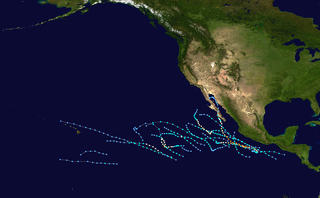
Tropical cyclones of the 2000 Pacific hurricane season | ||
|---|---|---|
 | ||