The 2011 Pacific hurricane season was a below average season in terms of named storms, although it had an above average number of hurricanes and major hurricanes. During the season, 13 tropical depressions formed along with 11 tropical storms, 10 hurricanes and 6 major hurricanes. The season officially began on May 15 in the East Pacific Ocean, and on June 1 in the Central Pacific; they both ended on November 30. These dates conventionally delimit the period of each year when most tropical cyclones form in the Pacific basin. The season's first cyclone, Hurricane Adrian formed on June 7, and the last, Hurricane Kenneth, dissipated on November 25.

The 2012 Pacific hurricane season was a moderately active Pacific hurricane season that saw an unusually high number of tropical cyclones pass west of the Baja California Peninsula. The season officially began on May 15 in the eastern Pacific Ocean, and on June 1 in the central Pacific (from 140°W to the International Date Line, north of the equator; they both ended on November 30. These dates conventionally delimit the period of each year when most tropical cyclones form in these regions of the Pacific Ocean. However, the formation of tropical cyclones is possible at any time of the year. This season's first system, Tropical Storm Aletta, formed on May 14, and the last, Tropical Storm Rosa, dissipated on November 3.

The 2016 Pacific hurricane season was tied as the fifth-most active Pacific hurricane season on record, alongside the 2014 season. Throughout the course of the year, a total of 22 named storms, 13 hurricanes and six major hurricanes were observed within the basin. Although the season was very active, it was considerably less active than the previous season, with large gaps of inactivity at the beginning and towards the end of the season. It officially started on May 15 in the Eastern Pacific, and on June 1 in the Central Pacific ; they both ended on November 30. These dates conventionally delimit the period of each year when most tropical cyclones form in these regions of the Pacific Ocean. However, tropical development is possible at any time of the year, as demonstrated by the formation of Hurricane Pali on January 7, the earliest Central Pacific tropical cyclone on record. After Pali, however, no tropical cyclones developed in either region until a short-lived depression on June 6. Also, there were no additional named storms until July 2, when Tropical Storm Agatha formed, becoming the latest first-named Eastern Pacific tropical storm since Tropical Storm Ava in 1969.

The 2017 Pacific hurricane season was an above average Pacific hurricane season in terms of named storms, though less active than the previous three, featuring eighteen named storms, nine hurricanes, and four major hurricanes. Despite the considerable amount of activity, most of the storms were weak and short-lived. The season officially started on May 15 in the eastern Pacific Ocean, and on June 1 in the central Pacific; they both ended on November 30. These dates conventionally delimit the period of each year when most tropical cyclones form in the respective regions. However, the formation of tropical cyclones is possible at any time of the year, as illustrated in 2017 by the formation of the season's first named storm, Tropical Storm Adrian, on May 9. At the time, this was the earliest formation of a tropical storm on record in the eastern Pacific basin proper. The season saw near-average activity in terms of accumulated cyclone energy (ACE), in stark contrast to the extremely active seasons in 2014, 2015, and 2016; and for the first time since 2012, no tropical cyclones formed in the Central Pacific basin. However, for the third year in a row, the season featured above-average activity in July, with the ACE value being the fifth highest for the month. Damage across the basin reached $375.28 million (2017 USD), while 45 people were killed by the various storms.

Hurricane Dora was the strongest tropical cyclone in the northeastern Pacific in 2011 that brought minor impacts to Mexico and the US in July of that year. The fourth named storm, fourth hurricane, and second major hurricane of the year, Dora developed from a tropical wave south of Honduras on July 18. Moving northwestward in favorable conditions, the system quickly intensified to tropical storm status and attained hurricane intensity the next day. Rapid intensification ensued shortly thereafter, bringing the storm to its peak intensity on July 21 as a Category 4 hurricane, with a minimum barometric pressure of 929 mbar and maximum sustained winds of 155 mph (250 km/h). However, the storm's path into an area with cool sea surface temperatures and wind shear caused Dora to quickly deteriorate and weaken. By July 24, Dora had degenerated into a remnant low-pressure area west of the Baja California Peninsula.

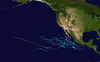
The 2014 Pacific hurricane season was an event in the annual cycle of tropical cyclone formation. It officially began on May 15 in the eastern Pacific—defined as the region east of 140°W—and began on June 1 in the central Pacific, defined as the region west of 140°W to the International Date Line; both ended on November 30.

Tropical Storm Lidia was a large tropical cyclone that caused flooding in Baja California Peninsula and parts of western Mexico. The fourteenth tropical cyclone and twelfth named storm of the 2017 Pacific hurricane season, Lidia developed from a large area of disturbed weather west of the Pacific Coast of Mexico on August 31. The storm intensified while moving generally northward or northwestward, peaking with maximum sustained winds of 65 mph (105 km/h) later that day. On September 1, Lidia made landfall in Mexico near Puerto Chale, Baja California Sur, at peak intensity. The storm weakened while traversing the peninsula, ultimately emerging over the Pacific Ocean on September 3, where the storm degenerated into a remnant low. The system brought thunderstorms and wind gusts to Southern California, before dissipating on September 4.

The 2023 Atlantic hurricane season is the current hurricane season in the Atlantic Ocean in the Northern Hemisphere. It officially began on June 1, and will end on November 30. These dates, adopted by convention, historically describe the period in each year when most tropical cyclogenesis occurs in the Atlantic. However, the formation of subtropical or tropical cyclones is possible at any time of the year, as demonstrated by the formation of a subtropical storm on January 16, the earliest start of an Atlantic hurricane season since Hurricane Alex in 2016. This system went unnamed operationally, as the National Hurricane Center (NHC) treated it as non-tropical.

The 2020 Pacific hurricane season was the least active Pacific hurricane season since 2011. Altogether, 21 tropical cyclones developed. The season was near average in terms of tropical storms, featuring a total of 17, but had a well below average number of hurricanes and major hurricanes, with only 4 hurricanes and 3 major hurricanes forming. Additionally, no tropical cyclones formed in the Central Pacific basin for the first time since 2017, marking the start of a series of seasons with no tropical cyclogenesis occurring there. The season officially began on May 15 in the East Pacific Ocean, and on June 1 in the Central Pacific (from 140°W to the International Date Line, north of the equator; they both ended on November 30. These dates conventionally delimit the period of each year when most tropical cyclones form in the respective regions. However, the formation of tropical cyclones is possible at any time of the year, as illustrated in 2020 by the formation of the season's first system, Tropical Depression One-E, on April 25. This the earliest formation of a tropical cyclone on record in the eastern Pacific basin proper.

The 2021 Pacific hurricane season was a moderately active Pacific hurricane season, with above-average activity in terms of number of named storms, but below-average activity in terms of major hurricanes, with 19 named storms, 8 hurricanes, and 2 major hurricanes forming in all. It also had a near-normal accumulated cyclone energy (ACE). The season officially began on May 15, 2021 in the Eastern Pacific Ocean, and on June 1, 2021, in the Central Pacific in the Northern Hemisphere. The season ended in both regions on November 30, 2021. These dates historically describe the period each year when most tropical cyclogenesis occurs in these regions of the Pacific and are adopted by convention. However, the formation of tropical cyclones is possible at any time of the year, as illustrated by the formation of Tropical Storm Andres on May 9, which was the earliest forming tropical storm on record in the Eastern Pacific. Conversely, 2021 was the second consecutive season in which no tropical cyclones formed in the Central Pacific.

Hurricane Lorena was a strong Pacific hurricane in September 2019 that brought heavy rainfall, flooding, and mudslides to Southwestern Mexico and the Baja California Peninsula and also brought severe weather to the U.S. state of Arizona. Lorena was the thirteenth named storm and seventh and final hurricane of the 2019 Pacific hurricane season. A tropical wave, originally from the North Atlantic, entered the East Pacific basin on September 16. With increasing thunderstorm development, Lorena formed as a tropical storm on September 17 alongside Tropical Storm Mario. Lorena made its passage northwestward and quickly gained strength before it made landfall as a Category 1 hurricane in Jalisco on September 19. Due to interaction with the mountainous terrain, Lorena weakened back to a tropical storm. After moving into the warm ocean temperatures of the Gulf of California, however, Lorena re-strengthened into a hurricane, and reached its peak intensity with 1-minute sustained winds of 85 mph (137 km/h) and a minimum barometric pressure of 985 millibars (29.1 inHg) Lorena made a second landfall in the Mexican state of Baja California Sur, and quickly weakened thereafter. Lorena weakened to a tropical storm over the Gulf of California, and became a remnant low on September 22, shortly after making landfall in Sonora as a tropical depression. The remnant low moved inland over Mexico, and eventually dissipated inland over Arizona on September 24.

Hurricane Dolores was a powerful and moderately damaging tropical cyclone whose remnants brought record-breaking heavy rains and strong winds to California. The seventh named storm, fourth hurricane, and third major hurricane of the record-breaking 2015 Pacific hurricane season, Dolores formed from a tropical wave on July 11. The system gradually strengthened, attaining hurricane status on July 13. Dolores rapidly intensified as it neared the Baja California peninsula, finally peaking as a Category 4 hurricane on the Saffir–Simpson scale with winds of 130 mph (215 km/h) on July 15. An eyewall replacement cycle began and cooler sea-surface temperatures rapidly weakened the hurricane, and Dolores weakened to a tropical storm two days later. On July 18, Dolores degenerated into a remnant low west of the Baja California peninsula.

Hurricane Douglas was a strong tropical cyclone that became the closest passing Pacific hurricane to the island of Oahu on record, surpassing the previous record held by Hurricane Dot in 1959. The eighth tropical cyclone, fifth named storm, first hurricane, and first major hurricane of the slightly below-average 2020 Pacific hurricane season, Douglas originated from a tropical wave which entered the basin in mid-July. Located in favorable conditions, the wave began to organize on July 19. It became a tropical depression on July 20 and a tropical storm the following day. After leveling off as a strong tropical storm due to dry air, Douglas began rapid intensification on July 23, becoming the season's first major hurricane the following day and peaking as a Category 4 hurricane. After moving into the Central Pacific basin, Douglas slowly weakened as it approached Hawaii. The storm later passed north of the main islands as a Category 1 hurricane, passing dangerously close to Oahu and Kauai, causing minimal damage, and resulting in no deaths or injuries. Douglas weakened to tropical storm status on July 28, as it moved away from Hawaii, before degenerating into a remnant low on July 29 and dissipating on the next day.

Hurricane Marco was the first of two tropical cyclones to threaten the Gulf Coast of the United States within a three-day period. The thirteenth named storm and third hurricane of the record-breaking 2020 Atlantic hurricane season, Marco developed from a fast-moving tropical wave west of the Windward Islands and south of Jamaica on August 20. The fast motion of the wave inhibited intensification initially, but as the wave slowed down and entered a more favorable environment, the system developed into a tropical depression, which in turn rapidly intensified into a strong tropical storm. Due to strong wind shear, Marco's intensification temporarily halted. However, after entering the warm waters of the Gulf of Mexico on August 23, Marco briefly intensified into a hurricane, only to quickly weaken later that evening due to another rapid increase in wind shear. Marco subsequently weakened to a tropical depression before degenerating into a remnant low early the next morning. Marco's remnants subsequently dissipated on August 26.

Hurricane Paulette was a strong and long-lived Category 2 Atlantic hurricane which became the first to make landfall in Bermuda since Hurricane Gonzalo did so in 2014. The sixteenth named storm and sixth hurricane of the record-breaking 2020 Atlantic hurricane season, Paulette developed from a tropical wave that left the coast of Africa on September 2. The wave eventually consolidated into a tropical depression on September 7. Paulette fluctuated in intensity over the next few days, due to strong wind shear, initially peaking as a strong tropical storm on September 8. It eventually strengthened into a hurricane early on September 13 as shear decreased. On September 14, Paulette made landfall in northeastern Bermuda as a Category 2 hurricane, while making a gradual turn to the northeast. The cyclone further strengthened as it moved away from the island, reaching its peak intensity with 1-minute sustained winds of 105 mph (169 km/h) and a minimum central atmospheric pressure of 965 mbar (28.5 inHg) on September 14. On the evening of September 15, Paulette began to weaken and undergo extratropical transition, which it completed on September 16. The hurricane's extratropical remnants persisted and moved southward then eastward, and eventually, Paulette regenerated into a tropical storm early on September 20 south of the Azores– which resulted in the U.S National Weather Service coining the phrase "zombie storm" to describe its unusual regeneration. Paulette's second phase proved short-lived, however, as the storm quickly weakened and became post-tropical again two days later. The remnant persisted for several days before dissipating south of the Azores on September 28. In total, Paulette was a tropical cyclone for 11.25 days, and the system had an overall lifespan of 21 days.

Tropical Storm Beta was a tropical cyclone that brought heavy rainfall, flooding, and severe weather to the Southeastern United States in September 2020. The twenty-third tropical depression and twenty-third named storm of the record-breaking 2020 Atlantic hurricane season, Beta originally formed from a trough of low pressure that developed in the northeastern Gulf of Mexico on September 10. The low moved slowly southwestward, with development hampered initially by the development of nearby Hurricane Sally. After Sally moved inland over the Southeastern United States and weakened, the disturbance became nearly stationary in the southwestern Gulf, where it began to organize. By September 16, the storm had gained a low-level circulation center and had enough organization to be designated as Tropical Depression Twenty-Two. The system held its intensity for a day due to the influence of strong wind shear and dry air, before eventually attaining tropical storm strength. It slowly moved northward and intensified to a mid-range tropical storm before dry air and wind shear halted its intensification. Beta then became nearly stationary on September 19, before starting to move west towards the Texas coast the next day, weakening as it approached. On September 21, Beta made landfall near Matagorda Peninsula, Texas as a minimal tropical storm. It subsequently weakened to a tropical depression the next day before becoming post-tropical early on September 23. Its remnants moved northeastward, before the center elongated and merged with a cold front early on September 25.

The 2023 Pacific hurricane season is the current Pacific hurricane season in the Northern Hemisphere. It officially began on May 15 in the eastern Pacific, and on June 1 in the central Pacific ; both will end on November 30. These dates, adopted by convention, historically describe the period in each year when most tropical cyclogenesis occurs in these regions of the Pacific. There was no tropical cyclone activity in the basin for the first six weeks of the season, making this one of the latest-starting seasons on record. When the first system, Hurricane Adrian, developed on June 27, it became the second-latest forming first named storm in the eastern Pacific in the satellite era, behind only Tropical Storm Agatha in 2016.
The 2021 Pacific hurricane season was a moderately active hurricane season, with above-average tropical activity in terms of named storms, but featured below-average activity in terms of major hurricanes. It is the first season to have at least five systems make landfall in Mexico, the most since 2018. It was also the second consecutive season in which no tropical cyclones formed in the Central Pacific. The season officially began on May 15 in the Eastern Pacific, and on June 1 in the Central Pacific; both ended on November 30. These dates historically describe the period each year when most tropical cyclones form in the eastern and central Pacific and are adopted by convention. However, the formation of tropical cyclones is possible at any time of the year, as illustrated this year by the formation of Tropical Storm Andres on May 9. This was the earliest forming tropical storm on record in the Eastern Pacific.

Hurricane Enrique was a Category 1 Pacific hurricane that brought heavy rainfall and flooding to much of western Mexico in late June 2021. The fifth named storm and first hurricane of the 2021 Pacific hurricane season, Enrique developed from a tropical wave the entered the Pacific Ocean off the coast of Nicaragua on June 22. In an environment conducive for intensification, the disturbance moved west-northwestward and developed into a tropical storm by 6:00 UTC on June 25, as it was already producing winds of 40 mph (65 km/h), and received the name Enrique. Enrique strengthened steadily within an environment of warm waters and low-to-moderate wind shear while continuing its northwestward motion. By 12:00 UTC on June 26, Enrique had intensified into a Category 1 hurricane as the storm turned more northwestward. Nearing the coast of Mexico, Enrique reached its peak intensity around 6:00 UTC the following day, with maximum sustained winds of 90 mph (150 km/h) and a minimum barometric pressure of 972 mbar (28.7 inHg). Enrique, passing closely offshore west-central Mexico, maintained its intensity for another 24 hours as it turned northward toward the Gulf of California. Turning back to the northwest on June 28, increasing wind shear and dry air caused the hurricane to weaken. Enrique dropped to tropical storm status at 18:00 UTC that day, and further weakened to a tropical depression on June 30 just to the northeast of Baja California. The depression was absorbed into a larger low pressure area to the southeast later that day.

Hurricane Beatriz was a Category 1 Pacific hurricane that caused widespread flooding along much of the Pacific coast of southwestern Mexico in late June and early July 2023. The second named storm and second hurricane of the 2023 Pacific hurricane season, Beatriz developed from an area of low pressure that first formed offshore of southern Mexico on June 25. The disturbance was slow to organize, but due to the impending threat it posed to the Mexican coast, advisories were initiated on it as Potential Tropical Cyclone Two-E at 03:00 UTC on June 29. The system organized into a tropical depression six hours later. Later that day, the depression strengthened into a tropical storm and was named Beatriz. Closely paralleling the coast of Mexico, Beatriz rapidly intensified into a hurricane at 15:00 UTC on June 30. The storm peaked in intensity shortly after with maximum sustained winds of 85 mph (137 km/h) and a minimum barometric pressure of 992 mbar (29.3 inHg). Early on July 1, the hurricane's center brushed the coast near Punta San Telmo, after which it steadily lost organization. Beatriz weakened to a tropical storm shortly thereafter, and the system dissipated entirely by 18:00 UTC that day offshore of Cabo Corrientes.